Sold2024Ptolemy & Magini, pub. 1620 - Map of the British Isles (England, Scotland, Ireland) / Verso: Map ofThis early map engraving is from Claudius Ptolemaeus (Ptolemy) and Giovanni Antonio Magini's Geografia cio? Descrittione Universale della Terra Partita in due volumni, Nel Primo de' quali si contengonSee Sold Price
Sold2024Ptolemy & Magini, pub. 1620 - Map of India and Surrounding Islands (East Indies)This early map engraving is from Claudius Ptolemaeus (Ptolemy) and Giovanni Antonio Magini's Geografia cio? Descrittione Universale della Terra Partita in due volumni, Nel Primo de' quali si contengonSee Sold Price
Sold2024Ptolemy & Magini, pub. 1620 - Map of Sardinia & SicilyThis early map engraving is from Claudius Ptolemaeus (Ptolemy) and Giovanni Antonio Magini's Geografia cio? Descrittione Universale della Terra Partita in due volumni, Nel Primo de' quali si contengonSee Sold Price
Sold2024Ptolemy & Magini, pub. 1620 - Double Hemisphere Map of the WorldThis early map engraving is from Claudius Ptolemaeus (Ptolemy) and Giovanni Antonio Magini's Geografia cio? Descrittione Universale della Terra Partita in due volumni, Nel Primo de' quali si contengonSee Sold Price
Sold2023World: Ptolemy, pub. 1562 - Map of the Ancient WorldThis early map engraving is Joseph Moleti (Giseppi Moleti [Moletius])'s edition of Claudius Ptolemaeus (Ptolemy)'s Geographia. This is the first Moleti Latin edition of the work and was published by VSee Sold Price
Sold2023Ptolemy, pub. 1562 - Map of ItalyThis early map engraving is Joseph Moleti (Giseppi Moleti [Moletius])'s edition of Claudius Ptolemaeus (Ptolemy)'s Geographia. This is the first Moleti Latin edition of the work and was published by VSee Sold Price
Sold2023Ptolemy, pub. 1562 - Map of Sardinia & SicilyThis early map engraving is Joseph Moleti (Giseppi Moleti [Moletius])'s edition of Claudius Ptolemaeus (Ptolemy)'s Geographia. This is the first Moleti Latin edition of the work and was published by VSee Sold Price
Sold2023Ptolemy, pub. 1562 - Map of Sardinia & SicilyThis early map engraving is Joseph Moleti (Giseppi Moleti [Moletius])'s edition of Claudius Ptolemaeus (Ptolemy)'s Geographia. This is the first Moleti Latin edition of the work and was published by VSee Sold Price
Sold2021Tallis, John (Pub) 1852 Map. EuropeSteel Engraved Map with Original Outline Hand Color Published 1852-56 by John Tallis, London for "The Universal Pronouncing Dictionary" by Thomas Wright. Drawn & Engraved by John Rapkin. Centre fold aSee Sold Price
Sold2023Thomson, John (Pub) 1825 Map. EuropeCopper Engraved Map Published 1825 by John Thomson, Edinburgh for "The Edinburgh School Atlas" by N. R. Hewitt. Maps Engraved by Hewitt. Original Outline Hand Colour. Rare. Paper Size: 10.5 x 8 inch (See Sold Price
Sold2021Thomson, John (Pub) 1825 Map. EuropeCopper Engraved Map Published 1825 by John Thomson, Edinburgh for "The Edinburgh School Atlas" by N. R. Hewitt. Maps Engraved by Hewitt. Engraved Vignette in corner. Original Outline Hand Colour. RareSee Sold Price
Sold2024Russell & Allen (Pub) 1812 Map. EuropeFolio Copper Engraved Map Published 1812 by Russell and Allen, Manchester for "A New And Commercial System Of Geography" Paper Size: 15.5 x 9 inch (39 x 23cm) Toning present.See Sold Price
Sold2023Ptolemy, Fries, pub. 1535 - Map of TurkeyThis important historic map is from Geographicae enarrationis libri octo Ex Bilibaldi Pirckeymheri tralatione, fed ad Graeca & prisca exemplaria.... The work was published in 1535 in Lyon after LorenzSee Sold Price
Sold2023Ptolemy, Fries, pub. 1535 - Map of Northern Africa and EgyptThis important historic map is from Geographicae enarrationis libri octo Ex Bilibaldi Pirckeymheri tralatione, fed ad Graeca & prisca exemplaria.... The work was published in 1535 in Lyon after LorenzSee Sold Price
Sold2021Lochhead (Pub) 1811 Rare Map. EuropeCopper Engraved Map Published 1811 by William Lochhead, Berwick for "Modern Geography: And a Compendious General Gazetteer" Rare. Folds as issued. Paper Size: 12 x 10.5 inch (30 x 27cm) Some tone spotSee Sold Price
Sold2021Tallis, John (Pub) 1852 Map. Turkey in EuropeSteel Engraved Map with Original Outline Hand Color Published 1852-56 by John Tallis, London for "The Universal Pronouncing Dictionary" by Thomas Wright. Drawn & Engraved by John Rapkin. Centre fold aSee Sold Price
Sold2021Thomson, John (Pub) 1825 Map. Russia in EuropeCopper Engraved Map Published 1825 by John Thomson, Edinburgh for "The Edinburgh School Atlas" by N. R. Hewitt. Maps Engraved by Hewitt. Engraved Vignette in corner. Original Outline Hand Colour. RareSee Sold Price
Sold2021Tallis, John (Pub) 1852 Map. Russia in EuropeSteel Engraved Map with Original Outline Hand Color Published 1852-56 by John Tallis, London for "The Universal Pronouncing Dictionary" by Thomas Wright. Drawn & Engraved by John Rapkin. Centre fold aSee Sold Price
Sold2023Thomson, John (Pub) 1825 Map. Russia in EuropeCopper Engraved Map Published 1825 by John Thomson, Edinburgh for "The Edinburgh School Atlas" by N. R. Hewitt. Maps Engraved by Hewitt. Original Outline Hand Colour. Rare. Paper Size: 10.5 x 8 inch (See Sold Price
Sold2021Lochhead (Pub) 1811 Rare Map. Russia in Europe"The Southern Part of Russia in Europe with Russian and Little Tartary" Copper Engraved Map Published 1811 by William Lochhead, Berwick for "Modern Geography: And a Compendious General Gazetteer" RareSee Sold Price
Sold2024Russell & Allen (Pub) 1812 Map. Northern States of Europe. Denmark Norway Sweden Russia PrussiaFolio Copper Engraved Map Published 1812 by Russell and Allen, Manchester for "A New And Commercial System Of Geography" Paper Size: 15.5 x 9 inch (39 x 23cm) Tone marks in margin, otherwise Good CondSee Sold Price
Sold2019Tallis (Pub) 1858 Map of Turkey in EuropeSteel Engraved Map Published 1858 by the London Printing and Publishing Co., London for "The History Of The War With Russia: Giving Full Details Of The Operations Of The Allied Armies" by Henry TyrrelSee Sold Price
Sold2022Kearsley (Pub) 1802 Map. Muscovy or Russia in EuropeCopper Engraved Map Published 1802 by George Kearsley, London for "The English Encyclopaedia..." Folds as issued. Paper Size: 16.5 x 10.5 inch (41 x 27cm) Minor wrinkles. Good ConditionSee Sold Price
Sold2017Ptolemy: Map of Bactria Scythia North India, 1597Map: Tabula Asiae VIII Cartographer: Ptolemy, Magini / Porro, P.Keschedt Place & Date: Cologne / 1597 Size: 6 3/4" x 5 1/4" Condition: b&w; overall age toning The eighth Ptolemaic Asia map from the MaSee Sold Price
Jun 09Worthington GalleriesAntique H/C Map EUROPE SOUS CHARLEMAGNE EN 814: EMPIRES D'OCCIDENT ET D'ORIENT$25
3 days LeftMark Louis Weseloh Estate LiquidationsSix - 17th c. Maps of Europe, Asia, England, Germany x2, Crete, Greece.8 1/4" x 6 5/8".$300
Jun 30Global Auctions CompanyHand Colored Engraved Map of Europe, Jean Baptiste Bourguignon Anville 1754$450
3 days LeftJasper521803 Poirson Map of Europe -- L'Europe divisee en ses Principaux Etats et d'apres le Traite de Paix$95
Jun 18DOYLE Auctioneers & AppraisersA block puzzle with maps of Europe, England, Ireland, Scotland, America and the World$100
BonhamsAFRICA MUNSTER (SEBASTIAN) Africa Lybia Morenlandt mit allen königreichen so zu unsern zeit...£300
3 days LeftJasper521775 d'Anville Map of Middle Ages Europe -- Germany, France, Italy, Spain, British Isles, In an$70


![World: Ptolemy, pub. 1562 - Map of the Ancient World: This early map engraving is Joseph Moleti (Giseppi Moleti [Moletius])'s edition of Claudius Ptolemaeus (Ptolemy)'s Geographia. This is the first Moleti Latin edition of the work and was published by V](https://p1.liveauctioneers.com/6581/307341/164260812_1_x.jpg?height=310&quality=70&version=1698409008)
![Ptolemy, pub. 1562 - Map of Italy: This early map engraving is Joseph Moleti (Giseppi Moleti [Moletius])'s edition of Claudius Ptolemaeus (Ptolemy)'s Geographia. This is the first Moleti Latin edition of the work and was published by V](https://p1.liveauctioneers.com/6581/306422/163689119_1_x.jpg?height=310&quality=70&version=1697805653)
![Ptolemy, pub. 1562 - Map of Sardinia & Sicily: This early map engraving is Joseph Moleti (Giseppi Moleti [Moletius])'s edition of Claudius Ptolemaeus (Ptolemy)'s Geographia. This is the first Moleti Latin edition of the work and was published by V](https://p1.liveauctioneers.com/6581/306422/163689120_1_x.jpg?height=310&quality=70&version=1697805653)
![Ptolemy, pub. 1562 - Map of Sardinia & Sicily: This early map engraving is Joseph Moleti (Giseppi Moleti [Moletius])'s edition of Claudius Ptolemaeus (Ptolemy)'s Geographia. This is the first Moleti Latin edition of the work and was published by V](https://p1.liveauctioneers.com/6581/310450/166144993_1_x.jpg?height=310&quality=70&version=1700658590)


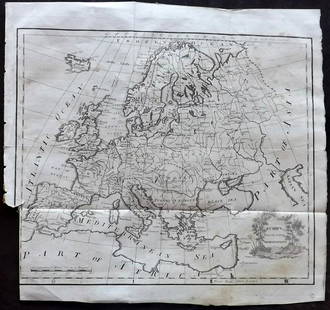


![Maps of Europe, c1800's (4) [180165] (1 of 4)](https://p1.liveauctioneers.com/2699/331495/178785788_1_x.jpg?height=282&quality=70&version=1717094933)


