Sold2021Speed map of the Roman Empire, 1626Heading: Author: Speed, John Title: A New Mappe of the Romane Empire Newly Described by John Speede Place Published: London Publisher:G. Humble Date Published: 1626 Description:See Sold Price
Sold2022Hand-Colored MapsHand-Colored Maps (2) items including a posthumous printing of John Speed 'A New Mappe of the Romane Empire' including original invoice from George Ritzlin Maps & Prints, depicting the areas encompassSee Sold Price
Sold2023Map Showing the Roman Empire-John Speed-Late 17th CenturyMap titled "A New Mappe of the Romane Empire" by John Speed and published by Bassett and Chiswell, circa 1676. Sheet shows map at center surrounded by vignettes of various cities and views of variousSee Sold Price
Sold2016[Roman Empire] MapA new Mappe of the Romane Empire, 1610.Incisione in coloratura coeva, 450x465 mm.See Sold Price
Sold2021Map of Turky, Arabia and Persia. Corrected from the[In A New general atlas : containing a geographical and historical account of all the empires, kingdoms and other dominions of the world, by John Senex][London, 1721]47 cm x 57 cm Watermarked paper. OSee Sold Price
Sold2023John Speede, "A New Map of Tartary"Or: "A Newe Mape of Tartary." Hand colored map "augmented" by British cartographer John Speede (1551 - 1629). Originally sold by London merchants Thomas Bassett of Fleet Street and Richard Chiswell inSee Sold Price
Sold2023Puerto Rico & Virgin Islands. Haiti, Hispaniola or St. Domingo. THOMSON 1830 mapPorto Rico and Virgin Isles // Haiti, Hispaniola or St. Domingo' by Drawn & engraved by John & George Menzies for John Thomson's "New General Atlas" (1830). Antique early 19th century atlas map with oSee Sold Price
Sold2019Two Maps from John Thomson's New General Atlas, "NorthTwo Maps from John Thomson's New General Atlas, "North America," 1814, and "Poland," America- H. - 21 1/2 in., W. - 28 1/2 in., Poland- H.- 21 in., W.- 27 1/2 in.See Sold Price
Sold2016John Cary: Portugal 1819Map: Portugal Maker: John Cary Publishing: John Cary, London Date: 1819 Size: 11 x 8.9 inches (280 x 225mm) Medium: Hand colored engraving From Cary's New Universal Atlas John Cary (1754-1835) was anSee Sold Price
Sold2022MITCHELL, SAMUEL AUGUSTUS. A New Universal Atlas Containing Maps of the Various Empires, Kingdoms,MITCHELL, SAMUEL AUGUSTUS. A New Universal Atlas Containing Maps of the Various Empires, Kingdoms, States and Republics of the World; With a Special Map of Each of the United States, Plans of Cities,See Sold Price
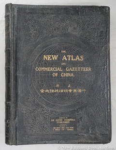
Sold2023Dingle, Edwin John51. Dingle, Edwin John. The New Atlas and Commercial Gazetteer of China. 28 color-printed maps and 18 color-printed statistical tables. Large folio, publisher's black cloth decorated in gilt and blindSee Sold Price
Sold2022MITCHELL'S UNIVERSAL ATLASNew Universal Atlas Containing Maps of the various Empires, Kingdoms, States, and Republics of the World, S. Augustus Mitchell, Philadelphia, 1847; Condition: boards detached; 17 1/4 x 14 inchesSee Sold Price
Sold2017Mitchell's 1849 New Universal AtlasHeading: Author: Mitchell, S. Augustus Title: New Universal Atlas Containing Maps of the various Empires, Kingdoms, States and Republics of the World. With a special map of each of the United States,See Sold Price
Sold2016Mitchell's New Universal Atlas 1847Heading: Author: Mitchell, S. Augustus Title: A New Universal Atlas Containing Maps of the Various Empires, Kingdoms, States and Republics of the World with a Special Map of each of the United StatesSee Sold Price
Sold2018MITCHELL, Samuel Augustus (1790-1868).* MITCHELL, Samuel Augustus (1790-1868). A New Universal Atlas Containing Maps of the Various Empires, Kingdoms, States, and Republics of the World, with a Special Map of Each of the United States, PlSee Sold Price
Sold2024Mitchell - Map of FloridaThis originally hand-colored, lithographed maps is from Samuel Augustus Mitchell's A New Universal Atlas Containing Maps of the various Empires, Kingdoms, States and Republics of the World.. The workSee Sold Price
Sold2021Ɵ CARY, JOHN. NEW AND CORRECT ENGLISH ATLAS. 1825Ɵ CARY, John. New and Correct English Atlas. single volume, engraved title and 47 maps, coloured in outline, modern half calf over original boards, 4to, 1825. (Qty. 1).See Sold Price
Sold2022SMITH, CHARLES Smith's New General Atlas Containing District Maps of All the Principal Empires,SMITH, CHARLES Smith's New General Atlas Containing District Maps of All the Principal Empires, Kingdoms & States throughout the World. London: C. Smith, 1809. Old calf-backed boards. 15 3/4 x 12 5/8See Sold Price
Sold2024Spanish North America. THOMSON. Texas, Mexico & Southwestern USA 1817 mapTitle: "Spanish North America". THOMSON. Texas, Mexico & Southwestern USA 1817 map Description: Spanish North America [northern part] by Drawn & engraved for John Thomson's "New General Atlas" (PublisSee Sold Price
Sold2023North America by John Thomson. Forts, Missions & Indian settlements 1817 mapTitle: "North America" by John Thomson. Forts, Missions & Indian settlements 1817 map Description: North America' by Drawn & engraved by Nathaniel Robert Hewitt for John Thomson's "New General Atlas"See Sold Price
Sold2023South America. New Granada & Peru Viceroyalties. Tucuman. THOMSON 1830 mapTitle: "South America". New Granada & Peru Viceroyalties. Tucuman. THOMSON 1830 map Description: South America' by Drawn & engraved by John Moffat for John Thomson's "New General Atlas" (1830). AntiquSee Sold Price
Sold2023America. North/South Americas. British Florida. Missions. THOMSON 1817 mapTitle: "America". North/South Americas. British Florida. Missions. THOMSON 1817 map Description: America' by Drawn & engraved by John & George Menzies for John Thomson's "New General Atlas" (PublishedSee Sold Price
Sold2023Corea and Japan by John Thomson. East Asia. Korea 1817 old antique map chartTitle: "Corea and Japan" by John Thomson. East Asia. Korea 1817 old antique map chart Description: Corea and Japan' by Drawn & engraved by John & George Menzies for John Thomson's "New General Atlas"See Sold Price
Sold2023West Indies. Caribbean islands Antilles Gulf of Mexico Florida. THOMSON 1830 mapTitle: West Indies. Caribbean islands Antilles Gulf of Mexico Florida. THOMSON 1830 map Description: West Indies' by Drawn & engraved for John Thomson's "New General Atlas" (1830). Antique early 19thSee Sold Price
Jun 13Swann Auction Galleries(BOTANICAL.) Robert John Thornton. New Illustration of the Sexual System of Carolus von Linnaeus$36,000
Jun 13Swann Auction Galleries(AMERICAS.) John Senex. A New Map of America From the latest Observations.$450
Jun 13Swann Auction Galleries(NEW YORK.) John Montresor. A Map of the Province of New York, with Part of Pensilvania, and New$3,800
Jun 13Swann Auction Galleries(RHODE ISLAND.) Henry F. Walling. Map of the State of Rhode Island and Providence Plantations.$500
Jun 13Swann Auction Galleries(WORLD.) Henry Teesdale; and John Dower (engraver). A New Chart of the World$1,500
Jun 13Swann Auction Galleries(NEW ENGLAND.) Arnoldus Montanus; or John Ogilby. Novi Belgii Quod Nunc Novi Jorck Vocatur, Novae qe$450
Jun 13Swann Auction GalleriesSELLER, JOHN. Two miniature hand-colored engraved maps: New England and New York [and] A New Mapp of$750
Jun 13Swann Auction Galleries(BRITISH COUNTIES.) John Speed. The Theatre of the Empire of Great Britaine.$1,900
Jun 13Swann Auction Galleries(NEW YORK CITY.) H. Walter; after John Bachmann. Vue General de New-York.$2,200
Jun 13Swann Auction Galleries(NEW YORK CITY.) Leon Auguste Asselineau; after John Bachmann. Vue Generale de New-York Prise a vol$2,200
Jun 13Swann Auction Galleries(PICTORIAL MAPS.) John Held, Jr. Motor Routes to "Real New England Inns".$600
Jun 13Swann Auction Galleries(NEW YORK CITY.) R.A. Welcke; after John Bachmann. Fifth Avenue from 42nd Street, Looking North *$450
Jun 13Swann Auction Galleries(CANADA.) Jonathan Carver. A New Map of the Province of Quebec, According to the Royal Proclamation$450
Jun 13Swann Auction Galleries(CIVIL WAR.) John Bachmann. Panorama of the Seat of War - Bird's Eye View of Virginia, Maryland,$600
Jun 13Swann Auction Galleries(HUDSON RIVER.) John Hill; after William Guy Wall. Palisades. No. 19 of the Hudson River Port Folio.$1,500
Jun 13Swann Auction Galleries(UNITED STATES.) John M. Atwood. Phelps's National Map of the United States, A Travellers Guide.$450
Jun 13Swann Auction Galleries(BOTANICAL.) Robert Warner; Benjamin Samuel Williams; Thomas Moore; and John Nugent Fitch. The$2,200
Jun 13Swann Auction Galleries(FASHION -- MENSWEAR.) Hart, Schaffner & Marx. Group of early 20th-century men's fashion brochures.$500


![[Maps & Atlases] Speede, John A New Mappe of the Romane Empire... First Image](https://p1.liveauctioneers.com/65/302397/161353272_1_x.jpg?height=300&quality=1&version=1694780602&width=300)
![[Maps & Atlases] Speede, John A New Mappe of the Romane Empire... First Image](https://p1.liveauctioneers.com/65/302397/161353272_1_x.jpg?height=300&quality=95&version=1694780602&width=300)


![[Roman Empire] Map: A new Mappe of the Romane Empire, 1610.Incisione in coloratura coeva, 450x465 mm.](https://p1.liveauctioneers.com/3336/90951/46908047_1_x.jpg?height=310&quality=70&version=1473763184)
![Map of Turky, Arabia and Persia. Corrected from the: [In A New general atlas : containing a geographical and historical account of all the empires, kingdoms and other dominions of the world, by John Senex][London, 1721]47 cm x 57 cm Watermarked paper. O](https://p1.liveauctioneers.com/6940/190006/95714289_1_x.jpg?height=310&quality=70&version=1609447005)


![Spanish North America. THOMSON. Texas, Mexico & Southwestern USA 1817 map: Title: "Spanish North America". THOMSON. Texas, Mexico & Southwestern USA 1817 map Description: Spanish North America [northern part] by Drawn & engraved for John Thomson's "New General Atlas" (Publis](https://p1.liveauctioneers.com/5584/314775/168780323_1_x.jpg?height=310&quality=70&version=1704837726)


![[MAP]. SPEED, John. A New Mappe of the Romane Empire. 1676. (1 of 2)](https://p1.liveauctioneers.com/197/329395/177650541_1_x.jpg?height=282&quality=70&version=1715364962)


![SELLER, JOHN. Two miniature hand-colored engraved maps: New England and New York [and] A New Mapp of (1 of 1)](https://p1.liveauctioneers.com/199/332329/179231700_1_x.jpg?height=282&quality=70&version=1717450360)


