Sold20181968 Bollmann Pictorial Map of New York City -- NewTitle/Content of Map: 1968 Bollmann Pictorial Map of New York City -- New York Picture and Street Map Date Printed: 1968, Braunschweig, Germany Cartographer: H Bollmann, published by Bollmann BildkartSee Sold Price
Sold2022Vintage Map Print - America - Map of Manhattan - New York City - United StatesTitle: Vintage Map Print - America - Map of Manhattan - New York City - United States Date/Period: 1938 Dimension: 33 cm x 26 cm Material: Paper Additional Information: Vintage map of Manhattan. ThisSee Sold Price
Sold2022(PICTORIAL MAPS -- MANUSCRIPT.) [New York City, Queens, 1776].(PICTORIAL MAPS -- MANUSCRIPT.) [New York City, Queens, 1776]. Pen and ink on heavy artist's stock. 15¾x21½ inches sheet size, wide margins; vertical fold at center. Np, mid-19th century ManSee Sold Price
Sold20231860 New York City Business MAPS Manhattan Illustrated Corporation Plates Foldouts1860 New York City Business MAPS Manhattan Illustrated Corporation Plates Foldouts Manual of the Corporation of New York is a rare, Civil War-era handbook written for businesses and businessmen in NewSee Sold Price
Sold20221866 New York City Business HUGE MAP Manhattan Color Illustrated Corporation1866 New York City Business HUGE MAP Manhattan Color Illustrated Corporation Manual of the Corporation of New York is a rare, Civil War-era handbook written for businesses and businessmen in New YorkSee Sold Price
Sold2022Heavy Estate 23.5g 10K Pace College Class Ring NYCHeavy Estate 23.5g 10K Pace College Class Ring NYC, yellow gold, 10 kt, 15.1dwt, to fix, with Setter dog mascot on side. Manhattan, New York City and Westchester County campuses. Note badly broken stoSee Sold Price
Sold2022John Reilly Manhattan Bridge New York City PaintingOil on Board painting is approx 20" x 24" . John Reilly (1942-2021) was born in Brooklyn New York. John received his early art training at the School of Art and Design in Manhattan, where he studied aSee Sold Price
Sold2021Fine map of New York City and Brooklyn, 1872Title: Fine map of New York City and Brooklyn, 1872 Description: Beautifully centered double-page vintage map of Manhattan Island and Brooklyn, with inset of the Northern Portion of New York City andSee Sold Price
Sold2022Uncommon Railroad map of New York City, Rand McNallyHighly detailed map of Manhattan and the surrounding boroughs with special attention to Elevated Railroads, Metropolitan Railroads, Steamboat Piers and Railroad Piers. Steamship lines located and nameSee Sold Price
Sold20211898 Cram Map of New York City -- Map of New York City…Title: 1898 Cram Map of New York City -- Map of New York City… Cartographer: G Cram Year / Place: 1898, Chicago Map Dimension (in.): 21.4 X 13.7 in. This is an excellent double-page map of ManhattanSee Sold Price
Sold2019Hagstrom’s Map of Manhattan and BronxTitle: Hagstrom’s Map of Manhattan and Bronx Publication Date: 1951 Publisher: Hagstrom Company Dimensions: 42.5 X 22 Additional Information: New York City contents house number guidesubway * eSee Sold Price
Sold20231971 New York City School Building Map1971 Board of Education City of New York school building and large scale housing map of Manhattan. Surface wear consistent with exposure, tearing and creasing observed. Measures approx. 43 x 52 inchesSee Sold Price
Sold2016Map of New York City & Plan of Fort Washington (PortEngraved by George Hayward for D.T. Valentine's Manual. Map features northern Manhattan with Revolutionary War battles and troop movements, hightlighted by number on right side of map. The full titleSee Sold Price
Sold2018Mitchell: Antique Map of New York City, 1860Title/Content of Map: 1860 Mitchell Map of New York -- Plan of New York & c. Date Printed: 1860, Philadelphia Cartographer: S Mitchell Size: 13.5 x 10.5 in. An excellent map of lower Manhattan, EllisSee Sold Price
Sold20231862 New York City 1ed Business Manhattan Color Plates Illustrated MAPS Indians1862 New York City 1ed Business Manhattan Color Plates Illustrated MAPS Indians Manual of the Corporation of New York is a rare, Civil War-era handbook written for businesses and businessmen in New YoSee Sold Price
Sold20171865 Colton New York City Map1865 Colton New York City Map -- New York City Brooklyn, Jersey City, Hoboken, Etc. C. B. Colton 1865 New York 24 x 17 in. This nice map of New York City, including Manhattan, Brooklyn, Jersey City anSee Sold Price
Sold2021VINTAGE OLD NEW YORK CITY MAP, 4 in 1, MANHATTAN,VINTAGE OLD NEW YORK CITY MAP, 4 in 1, MANHATTAN, SUBWAY, FINANCIAL SECTION etc. VINTAGE OLD NEW YORK CITY MAP, 4 in 1, MANHATTAN, SUBWAY, FINANCIAL SECTION etc. Description Old Vintage GEOGRAPHIA LATSee Sold Price
Sold2022John Reilly New York City Manhattan PaintingNew York City Painting is approx 18" x 24"See Sold Price
Sold2021Vintage Map Of Greenwich Village, New York CityOriginal 1960 map of Greenwich Village, New York City by Lawrence Fahey. Stated 1st edition. Dimensions: 25" X 38" overall including frameSee Sold Price
Sold2021RAPKIN - New York Manhattan Map 1852[NEW YORK CITY] - J. Rapkin. New York. London and New York: John Tallis & Co., [1852]. Engraved map by Rapkin within an ornamental border, with six engraved inset views by H. Winkles. Sheet size: 21 3See Sold Price
Sold20232 XL MTA Subway & Chelsea Map LithographsSet of 2 XL NYC Maps. 1 marked MTA New York City Subway, 2004 depicting the subway map from The Bronx, Manhattan, Queens and Brooklyn. The other lithograph reads Chelsea, garment district, flower distSee Sold Price
Sold20242 XL MTA Subway & Chelsea Map LithographsSet of 2 XL NYC Maps. 1 marked MTA New York City Subway, 2004 depicting the subway map from The Bronx, Manhattan, Queens and Brooklyn. The other lithograph reads Chelsea, garment district, flower distSee Sold Price
Sold2021EARLY FRAMED NYC MAP, PART OF WARD 9, NEW YORK CITYEARLY FRAMED NYC MAP, PART OF WARD 9, NEW YORK CITY PART OF SECTION 2, FRAMED AND MATTED, MAKER OR DATE UNKNOWN. MAP MEASURES 23" X 32". IN VERY NICE ESTATE CONDITION, FROM WOODSTOCK, N.Y. ESTATE.See Sold Price
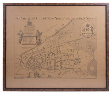
Sold2023REPLICA OF LAING'S MAP OF MANHATTAN"A Plan of the City of New York from an actual Survey" for His Excellency John Montgomerie, by William Bradford, printed on tan paper, in a faux tortoiseshell frame, under glass, 23" x 26", good condiSee Sold Price
Jun 09Estate Collection Auctioneer1986 Photo The Staten Island Anchorage viewed from Narrows Bridge Tower$250
8 hrs LeftRapid Estate Liquidators and Auction GalleryBoy Scout Council Shoulder Badges Lot Of 24 C$85
3 days LeftJasper521874 Holmes Plan of New York's Upper East Side -- Map of the Common Lands from 76th to 93rd Street$750


![(PICTORIAL MAPS -- MANUSCRIPT.) [New York City, Queens, 1776].: (PICTORIAL MAPS -- MANUSCRIPT.) [New York City, Queens, 1776]. Pen and ink on heavy artist's stock. 15¾x21½ inches sheet size, wide margins; vertical fold at center. Np, mid-19th century Man](https://p1.liveauctioneers.com/199/251723/130782406_1_x.jpg?height=310&quality=70&version=1655133895)


![RAPKIN - New York Manhattan Map 1852: [NEW YORK CITY] - J. Rapkin. New York. London and New York: John Tallis & Co., [1852]. Engraved map by Rapkin within an ornamental border, with six engraved inset views by H. Winkles. Sheet size: 21 3](https://p1.liveauctioneers.com/7533/208644/106251124_1_x.jpg?height=310&quality=70&version=1624641782)