Sold2023[PICTORIAL MAPS]. Six travel maps and brochures. Includes: ...[PICTORIAL MAPS]. Six travel maps and brochures. Includes: RENTSCHLER, F. Historical Map of the Old Northwest Territory. 1937. New York: Farrar and Rinehart Inc. 23 x 17 ¼”. Folded. StoredSee Sold Price
Sold20201940s Indiana Pictorial Travel Map -- See IndianaTitle/Content of Map: 1940s Indiana Pictorial Travel Map -- See Indiana Date: 1940s Cartographer: Size: 22 X 17 in. This is a fascinating pictorial map of Indiana showing many points of interests - soSee Sold Price
Sold2022(2) LUCIEN BOUCHER , ORIGINAL PICTORIAL MAPLUCIEN BOUCHER (1889-1971) (2) ORIGINAL AIR FRANCE COLOR LITHOGRAPH PLANISPHERE PICTORIAL TRAVEL MAPS OF THE WORLD FOR AIRLINE DESTINATIONS OF AIR FRANCE , TITLED "NOVA ET VETERA" , Sur La Vieille TerSee Sold Price
Sold2018London The Bastion of Liberty. Vintage Tourism TravelLondon The Bastion of Liberty. Vintage Tourism Travel Map Poster. London: Pictorial Maps Ltd., ca. 1960s. Highly detailed offset lithograph map with an overview of London, vignettes of notable sites aSee Sold Price
Sold2023Fly CAT / See Taiwan. Government Information Office, Republ...Fly CAT / See Taiwan. Government Information Office, Republic of China, ca. 1960s. Pictorial airline travel poster map of Taiwan. CAT’s routes and airports are marked with pink lines and red dotSee Sold Price
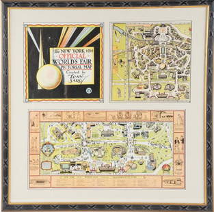
Sold2022Framed Tony Sarg 1939 World's Fair Pictorial MapTony Sarg (American, 1880-1942), "The New York 1939 Official World's Fair Pictorial Map Created by Tony Sarg 25¢" cover and Transportation Zone maps, three pieces matted and under glass in paintedSee Sold Price
Sold2021Color pictorial bird's-eye airline route maps 1929Heading: (Aviation - pictorial route maps) Author: Title: Western Air Express: Travel by Air, Speed - Comfort - Dependability Place Published: [California?] Publisher:Western Air Express Date PuSee Sold Price
Sold2022LUCIEN BOUCHER , ORIGINAL AIR FRANCE PLANISPHEREOriginal Air France Planisphere Travel Map by Lucien Boucher , LUCIEN BOUCHER (1889-1971) ORIGINAL AIR FRANCE COLOR LITHOGRAPH PICTORIAL PLANISPHERE MAP OF THE WORLD FOR AIRLINE DESTINATIONS OF AIR FRSee Sold Price
Sold2022LUCIEN BOUCHER , ORIGINAL AIR FRANCE PLANISPHEREOriginal Air France Planisphere Travel Map by Lucien Boucher , LUCIEN BOUCHER (1889-1971) ORIGINAL AIR FRANCE COLOR LITHOGRAPH PICTORIAL PLANISPHERE MAP OF THE WORLD FOR AIRLINE DESTINATIONS OF AIR FRSee Sold Price
Sold2016Three maps by Victor LevasseurHeading: Author: Levasseur, Victor Title: Three maps by Victor Levasseur Place Published: Paris Publisher: Date Published: c.1850 Description: Engraved maps, surrounded bySee Sold Price
Sold20181888 Tunnison Pictorial Representation of Means ofTitle/Content of Map: 1888 Tunnison Pictorial Representation of Means of Travel [verso] Russia in Europe -- How the World Travels [verso] Tunison's Russia in Europe Date: 1888, Jacksonville, IllinoisSee Sold Price
Sold2017My African Journey, Winston Churchill, 1908My African Journey: With Sixty-one Photographs by the Author and Lieutenant-colonel Gordon Wilson, and Three Maps churchill, Winston Spencer hodder & Stoughton, London, 1908 Red pictorial cloth stampeSee Sold Price
Sold2017[Travel] Collection of 17 Travel Souvenir Photo Books[Travel] Collection of 17 Travel Souvenir Photo Books and Maps. American and European, bulk 1930s. Color wrappers or pictorial buckram, destinations and sites comprising: Los Angeles, New York, ChicagSee Sold Price
Sold2021Alan Moorehead. Three Titles.A three book selection by Alan Moorehead. All in original pictorial dust-jackets.[small repairs]. Book One. "The White Nile" 1960. Publishers red cloth with gilt title to spine. Map endpapers. Name onSee Sold Price
Sold2021Three Title - Sea-faring BooksBook I. 'H.M.S. Fidelity' 1957. Full-page illustrations. Book II. 'Kicking Canvas' 1957. Pictorial dust-jacket. [some wear] Name on inside. Map endpapers. Full-page illustrations. Book IISee Sold Price
Sold20181945 Forest Lawn, CA Pictorial Map -- Pictorial Map ofTitle/Content of Map: 1945 Forest Lawn, CA Pictorial Map -- Pictorial Map of Forest Lawn Memorial - Park, Glendale, California Date: 1945, Glendale CA Cartographer: Forest Lawn Assoc. Size: 23.5 X 18.See Sold Price
Sold2022(PICTORIAL MAPS.) John Diakoff; G. Primakoff; and P. Sergeeff. Map of China.(PICTORIAL MAPS.) John Diakoff; G. Primakoff; and P. Sergeeff. Map of China. Enormous chromolithographed map of China with profuse pictorial illustration, inset charts, reference tables, and scenic viSee Sold Price
Sold2022(PICTORIAL MAPS.) Ignatz Sahula. Map of the 18th Annual Convention of the National Association of(PICTORIAL MAPS.) Ignatz Sahula. Map of the 18th Annual Convention of the National Association of Real Estate Boards. City of Detroit - June 23 to June 26 1925. Detroit is Yours Realtors! Large color-See Sold Price
Sold2022(PICTORIAL MAPS.) Charles Turzak & Henry Chapman. An Illustrated Map of Chicago • Youthful(PICTORIAL MAPS.) Charles Turzak & Henry Chapman. An Illustrated Map of Chicago • Youthful City of the Big Shoulders • Restless • Ingenious • Wilful • Violent • ProSee Sold Price
Sold2022Marvelous pictorial map of the WorldHeading: (Maps) Author: Ensign & Thayer Title: World at One View Place Published: New York Publisher: Date Published: 1847 Description: Lithographed double-hemisphere map of theSee Sold Price
Sold2022(PICTORIAL MAPS.) D.E. Bates. Cunard R.M.S. Caronia / Great African Cruise 1950.(PICTORIAL MAPS.) D.E. Bates. Cunard R.M.S. Caronia / Great African Cruise 1950. Color offset-printed pictorial map advertising the Caronia's route on a two-and-a-half-month's-long affair: departing NSee Sold Price
Sold2022(PICTORIAL MAPS -- INTOXICATION INFATUATION.) H.J. (Heinie) Lawrence. Map Showing Isle of Pleasure,(PICTORIAL MAPS -- INTOXICATION INFATUATION.) H.J. (Heinie) Lawrence. Map Showing Isle of Pleasure, Scale Two Fingers to the Drink. Offset color-printed map of an alcohol-obsessed land loaded with allSee Sold Price
Sold2021(PICTORIAL MAPS -- CHINA.) Group of 3 large offset(PICTORIAL MAPS -- CHINA.) Group of 3 large offset color-printed posters of Chinese natural and cultural heritage sites. China, mid-twentieth century *Taishan Mingsheng Tu. Scenic trail map of Mount TSee Sold Price
Sold2022(PICTORIAL MAPS.) Louise Jefferson. Africa, A Friendship Map.(PICTORIAL MAPS.) Louise Jefferson. Africa, A Friendship Map. Offset color-printed pictorial map of Africa. 28¼x26¼ inches sheet size; margins shaved to decorative border, imprint at lower eSee Sold Price
1818 AuctioneersTravel. Africa. Roberts, John S. - Africa, and African Travel and Adventure, &c. London: W. P.£22(2 bids)
1818 AuctioneersTravel. Far East. Three titles: Peck, Graham - Through China's Wall. London: 1941. 2nd impression;£10
5 days LeftJasper521720 Chatelain Map of Scotland -- Nouvelle Carte d'Ecosse, ou l'on Fait Observer l'Etat de la Nobles$240
1 day LeftTrillium Antique Prints & Rare BooksKendall & Nebel's War between the United States and Mexico? - Volume with 13 Folio Lithographs$5,000
1818 AuctioneersDecorative cloth bindings. Four books: The Empire Annual for Girls. London: 1910; Other Men's Minds.£24(5 bids)


![[PICTORIAL MAPS]. Six travel maps and brochures. Includes: ...: [PICTORIAL MAPS]. Six travel maps and brochures. Includes: RENTSCHLER, F. Historical Map of the Old Northwest Territory. 1937. New York: Farrar and Rinehart Inc. 23 x 17 ¼”. Folded. Stored](https://p1.liveauctioneers.com/928/305275/163151901_1_x.jpg?height=310&quality=70&version=1697054833)
![[PICTORIAL MAPS – TRAVEL]. Three Pictorial Maps. 1940s/50s.... First Image](https://p1.liveauctioneers.com/928/325952/175495561_1_x.jpg?height=300&quality=1&version=1712935174&width=300)
![[PICTORIAL MAPS – TRAVEL]. Three Pictorial Maps. 1940s/50s.... First Image](https://p1.liveauctioneers.com/928/325952/175495561_1_x.jpg?height=300&quality=95&version=1712935174&width=300)


![Color pictorial bird's-eye airline route maps 1929: Heading: (Aviation - pictorial route maps) Author: Title: Western Air Express: Travel by Air, Speed - Comfort - Dependability Place Published: [California?] Publisher:Western Air Express Date Pu](https://p1.liveauctioneers.com/642/204898/103985846_1_x.jpg?height=310&quality=70&version=1621652446)


![1888 Tunnison Pictorial Representation of Means of: Title/Content of Map: 1888 Tunnison Pictorial Representation of Means of Travel [verso] Russia in Europe -- How the World Travels [verso] Tunison's Russia in Europe Date: 1888, Jacksonville, Illinois](https://p1.liveauctioneers.com/5584/128489/65352496_1_x.jpg?height=310&quality=70&version=1538523113)

![[Travel] Collection of 17 Travel Souvenir Photo Books: [Travel] Collection of 17 Travel Souvenir Photo Books and Maps. American and European, bulk 1930s. Color wrappers or pictorial buckram, destinations and sites comprising: Los Angeles, New York, Chicag](https://p1.liveauctioneers.com/928/104923/53749652_1_x.jpg?height=310&quality=70&version=1496865216)
![Alan Moorehead. Three Titles.: A three book selection by Alan Moorehead. All in original pictorial dust-jackets.[small repairs]. Book One. "The White Nile" 1960. Publishers red cloth with gilt title to spine. Map endpapers. Name on](https://p1.liveauctioneers.com/5584/209856/106821906_1_x.jpg?height=310&quality=70&version=1625608762)
![Three Title - Sea-faring Books: Book I. 'H.M.S. Fidelity' 1957. Full-page illustrations. Book II. 'Kicking Canvas' 1957. Pictorial dust-jacket. [some wear] Name on inside. Map endpapers. Full-page illustrations. Book II](https://p1.liveauctioneers.com/5584/208373/106103962_1_x.jpg?height=310&quality=70&version=1624395684)


![Carroll, Lewis [Charles Lutwidge Dodgson] (1 of 1)](https://p1.liveauctioneers.com/94/330664/178342370_1_x.jpg?height=282&quality=70&version=1716466933)