Sold2024Philippines. Southern Luzon Mindoro Visayas. ADMIRALTY sea chart 1866 (1912) mapCAPTION PRINTED BELOW PICTURE: 'China Sea - Philippine Islands between San Bernardino & Mindoro Straits with Adjacent Islands' DATE PRINTED: Surveyed to 1873. Published 1866. New edition 1911. CorrectSee Sold Price
Sold2024Fusan (Busan) harbour, South Korea. ADMIRALTY sea chart 1912 (1955) old mapCAPTION PRINTED BELOW PICTURE: 'Korea - South East Coast - Fusan Harbour' DATE PRINTED: Surveyed to 1913. Published 1912. New edition 1914. Corrections to 1955 IMAGE SIZE: Approx 102.5 x 69.5cm, 40.25See Sold Price
Sold2017De Wit Portolan Sea Chart of EuropeTotius Europae Victoria... Frederic De Wit (1630-1706). Engraved map with original hand color. Amsterdam, 1675. 20 x 35 1/2 inches sheet, 27 1/2 x 43 inches framed. “The most striking and decorativeSee Sold Price
Sold2023De Eylanden van Pehou' by VAN KEULEN. Penghu Islands Taiwan. VOC chart 1753 mapTitle: De Eylanden van Pehou' by VAN KEULEN. Penghu Islands Taiwan. VOC chart 1753 map Description: De Eylanden van Pehou' by Johannes van Keulen (1753). Early 18th century Dutch sea chart with old coSee Sold Price
Sold2022Dudley Sea Chart of DenmarkDUDLEY, Sir Robert (1574-1649). [Denmark] Carta particolare che comincia con il gran fiume Albis e contene parte dell mare Baltico e Ientrata al sondo di Danemarca... Engraved map. Florence, 1646.20 7See Sold Price
Sold2022Dudley Sea Chart of ArgentinaDUDLEY, Sir Robert (1574-1649). [Argentina] Carta particolare della costa di America Australe che comincia al C. di Matas sin al C. di Galegos. Engraved map. Florence, 1646. 20 7/8" x 16 1/8" sheet. SSee Sold Price
Sold2018c. 1650 Map: Mar del Zur Hispanis Mare PacificumHistoric Maps c. 1650 Hand-Colored Map "Mar del Zur Hispanis Mare Pacificum" by Joannes Jansson with California as an Island Earliest Pacific Sea Chart of the to Appear in a Dutch Atlas c. 1650, Hand-See Sold Price
Sold2016Caribbean Island Map, by Mount & Page, 1720 (rare &Spectacular sea chart of the Spanish Main to Puerto Rico, from Mount & Page's English Pilot, Fourth Book. Known as the most important English Atlas of Sea Chart covering the Mediterranean and North AmSee Sold Price
Sold20181700 Pacific sea chart with Island of California andTitle: Mer de Sud ou Pacifique contenant l'Isle de Californe. Map maker: Pierre Mortier Place and Year: Amsterdam, 1700 Dimensions: 60 x 74.5 cm (23.6 x 29.3 in) Technique: Copperplate engraving ColorSee Sold Price
Sold2023BOSTOCK, Frank (1866 – 1912). Bostock & Wormbwell’s World R...BOSTOCK, Frank (1866 – 1912). Bostock & Wombwell’s World Renowned Menagerie. Glasgow: Sam Lithgow, ca. 1905. Horizontal half-sheet color lithograph with an interior view of the giant traveSee Sold Price
Sold2022LARGE ARCHITECTS PRINT / MAP / CHART CABINETFantastic very large Architectural draftsman/chart/map/print flat file - George III-Style mahogany with satinwood inlay, inset tooled leather top. 8 Drawer over 4 drawer. from the Audubon Gallery, KinSee Sold Price
Sold2022François HERAIL 1980sFrançois HERAIL1980sOriginal "toi et moi", adorned with round diamondsIt is composed of two brushed 18k gold rings (750‰), pink for one with a cultured pearl from the Southern Seas, and greSee Sold Price
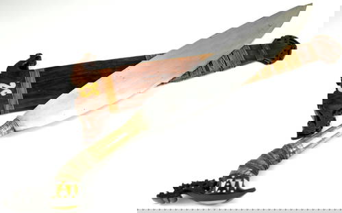
Sold2024FINE AND RARE 19TH C. PHILIPPINE MORO DATU'S BARONG SWORDThis is a classic sword of the Moro people of the southern Philippines and of the Sulu Sultanate area called a barong. These swords have a distinctive form that is specific to this region of South EasSee Sold Price
Sold20231861 Hagar Geology of Vermont 2 vols1861 Albert D Hager "Report of the Geology of Vermont" (2 vols), 1st edition with fold-out maps, charts, some in color, appears complete (not collated), rebound in cream colored cloth, some loose pageSee Sold Price
Sold2024Wassily Kadinsky 9x13 Untitled 1912 Watercolor - Sailboat, eye in black circleWassily Kandinsky (1866-1944): Untitled (1912) Watercolor - Sailboat, Eye in Black Circle. We are honored to present a rare and historically significant work by Wassily Kandinsky, one of the foremostSee Sold Price
Sold2024MAP, USA & Mexico, Auto Club of SoCalSouthwestern United States & Mexico. Automobile Club of Southern California, A Map of Exploration in the Spanish Southwest 1528-1793, from Supplement to Touring Topics, Volume Twenty-Four, Number One,See Sold Price
Sold202370304: A Marshall Islands Navigation Map Micronesia, 1A Marshall Islands Navigation Map Micronesia, 19th century Constructed of coconut palm leaf midribs and shells. Such maps or charts were for navigating specific atolls and islands in MicrSee Sold Price
Sold2024A PORTFOLIO OF EIGHTEEN MAPS INCLUDING TEXAS AND THE UNITED STATES, 19TH AND 20TH CENTURYA PORTFOLIO OF EIGHTEEN MAPS INCLUDING TEXAS AND THE UNITED STATES, 19TH AND 20TH CENTURY, comprising Colton's New Map of the State of Texas, 1866; August Mitchell's County Map of Texas, 1867; John MeSee Sold Price
SoldA Northern Luzon Head Hunter's AxeA Northern Luzon Head Hunter's Axe Philippines, Circa 19th-20th Century A.D. Height 17 5/8 inches (44.77 cm). Size Height 17 5/8 inches (44.77 cm). Provenance ProvenanceSee Sold Price
Sold2022Phoenix-eared "mallet" vase, Longquan, Southern Song dynasty (1127 - 1279)A vase made of celadon-glazed ceramic with a greenish-blue or sea-green moulded in the shape of a (mallet bottle with phoenix ears), which together with the handle-less shape was a recurring model inSee Sold Price
Sold2020Des Barres Map of NY Harbor*** START PRICE IS THE RESERVE *** [America] DES BARRES, Joseph Frederick Wallet (1729-1824). A Chart of New York Harbour with the Soundings Views of Land Marks and Nautical directions for the Use ofSee Sold Price
Sold2023Leon Bakst (1866 - 1924), Costume Design for Scheherazade (1910)Leon Bakst (1866 - 1924), Costume Design for Scheherazade (1910) Watercolor, gouache and pencil on paper 1912 Signed and dated 1912 (lower right). 65 x 44 cmSee Sold Price
Sold2022ARROWSMITH, AARON. Chart of the Pacific Ocean.ARROWSMITH, AARON. Chart of the Pacific Ocean. Large engraved navigational chart of the coastlines of Russia, Japan, Korea, China, the Philippines, Indonesia, and Australia. 73¼x31½ inches oSee Sold Price
2 days LeftJasper52Philippines Ports. Manila Cavite Anchorages. ADMIRALTY sea chart 1923 (1956) mapUS$300
2 days LeftJasper52Southern California Bight islands San Diego LA ADMIRALTY chart 1885 (1955) mapUS$300
2 days LeftJasper52Port di Napoli. Naples, Italy. ADMIRALTY sea chart 1937 (1955) old vintage mapUS$300
2 days LeftJasper52A New Sea Chart of the Coast of Portugal & part of Spain. MOUNT & PAGE 1758 mapUS$380
2 days LeftJasper52A Chart of the Coasts of Ireland & part of England. Wales. MOUNT & PAGE 1758 mapUS$600
Oct 12JM Hobby Supply and Railroad Artifact AuctionsSouthern Pacific RR One Hundred Golden Hours at Sea Book-1915US$40
Featured22 hrs LeftJasper521620 or 1621 Magini Map of the Arabian Peninsula [verso] Central Asia -- Tabula Asiae VI [verso]US$95
Oct 06Paul Arsenault AuctioneersRare Antique 1700's "A New and Correct Chart of the Sea Coast of New-England, from Cape Codd toUS$100
530 Lots AwayRapid Estate Liquidators and Auction GalleryNational Geographic Magazine Northern and Southern Hemispheres Atlantic Ocean 1940's Map SetUS$50
Oct 26Sofe Design AuctionsRare Map with the marking of Sea of Korea/East Sea by Jacques Nicolas Bellin ? 18th Century.US$100
3 days LeftSwann Auction GalleriesHENRY F. WALLING (1825-1889) Map of the City of New York and Its Vicinity. 1866.US$1,900
5 days LeftTrillium Antique Prints & Rare BooksDe Wit after Blaeu - Map of China and Japan, eastern AsiaUS$75(1 bid)
Oct 18Rail & Road Auctions1878 Maps of the New and Popular St. Louis and Texas Short Line Railroad Color LithographUS$40(1 bid)


![Dudley Sea Chart of Denmark: DUDLEY, Sir Robert (1574-1649). [Denmark] Carta particolare che comincia con il gran fiume Albis e contene parte dell mare Baltico e Ientrata al sondo di Danemarca... Engraved map. Florence, 1646.20 7](https://p1.liveauctioneers.com/1968/250616/130196505_1_x.jpg?height=310&quality=70&version=1654190895)
![Dudley Sea Chart of Argentina: DUDLEY, Sir Robert (1574-1649). [Argentina] Carta particolare della costa di America Australe che comincia al C. di Matas sin al C. di Galegos. Engraved map. Florence, 1646. 20 7/8" x 16 1/8" sheet. S](https://p1.liveauctioneers.com/1968/250616/130196501_1_x.jpg?height=310&quality=70&version=1654190895)


![Des Barres Map of NY Harbor: *** START PRICE IS THE RESERVE *** [America] DES BARRES, Joseph Frederick Wallet (1729-1824). A Chart of New York Harbour with the Soundings Views of Land Marks and Nautical directions for the Use of](https://p1.liveauctioneers.com/1968/163248/82424572_1_x.jpg?height=310&quality=70&version=1583340284)


![1620 or 1621 Magini Map of the Arabian Peninsula [verso] Central Asia -- Tabula Asiae VI [verso] (1 of 2)](https://p1.liveauctioneers.com/5584/343693/186665593_1_x.jpg?height=282&quality=70&version=1726603887)


![[CIVIL WAR] Military Map of Sherman's March to the Sea (1 of 2)](https://p1.liveauctioneers.com/7226/343781/186766904_1_x.jpg?height=282&quality=70&version=1726333566)


![[MAPS] DOUBLE-PAGE. LOT OF 4 SOLD TOGETHER (1 of 4)](https://p1.liveauctioneers.com/8124/343618/186530168_1_x.jpg?height=282&quality=70&version=1726178725)


