Sold2022Captain William Dampier & Alain Manesson Mallet 17th & 18th Century EngravingsCollection of four custom framed 17th and 18th century copper plate engravings. Buccaneer Naturalist Captain William Dampier (British, 1651-1715). French Cartographer Alain Manesson Mallet (1630-1706)See Sold Price
Sold2016Division of the Planisphere. Allain Manesson Mallet.Fig. 74. Division of the Planisphere and General World Map. Description de l'Univers Maker: Mallet, Allain Manesson. Origin: Frankfurt, Chez Jean David Zunner, 1685. Medium: Copperplate engraving. SheSee Sold Price
Sold2016Ancient Earth Divisions. Allain Manesson MalletFig. 66. Ancient Earth Divisions. Description de l'Univers Maker: Mallet, Allain Manesson. Origin: Frankfurt, Chez Jean David Zunner, 1685. Medium: Copperplate engraving. Sheet size: 7 3/4 x 6 in. ImaSee Sold Price
Sold2016Ancient Geography, Ocean & Sea. Allain Manesson Mallet.Fig. 80. Ancient Geography, the oceans and seas. Description de l'Univers Maker: Mallet, Allain Manesson. Origin: Frankfurt, Chez Jean David Zunner, 1685. Medium: Copperplate engraving. Sheet size: 7See Sold Price
Sold2016The Mediterranean Sea. Allain Manesson Mallet.Fig. 82. The Mediterranean Sea. Description de l'Univers Maker: Mallet, Allain Manesson. Origin: Frankfurt, Chez Jean David Zunner, 1685. Medium: Copperplate engraving. Sheet size: 7 3/4 x 6 in. ImageSee Sold Price
Sold2016Modern Understanding of the Mediterranean Sea. Mallet.Fig. 83. Modern understanding of the Mediterranean Sea. Description de l'Univers Maker: Mallet, Allain Manesson. Origin: Frankfurt, Chez Jean David Zunner, 1685. Medium: Copperplate engraving. Sheet sSee Sold Price
Sold2023Antique Map of Ireland, Frederick de WittDutch, 1629-1706..REGNI et INSULAE HIBERNIAE, latter 17th century, hand colored copper plate engraving, sight 28 x 19.5 in..toning, areas of foxing and discoloration, creases, under glass, not examineSee Sold Price
Sold2021Cambridgeshire Map, Joan Blaeu Amsterdam, 164517th Century Map by JOAN BLAEU: CANTABRIGIENSIS COMITATUS, Cambridgeshire by Joan Blaeu Amsterdam 1645. Copperplate engraving with original hand-colored map of Cambridgeshire from the Fourth Volume ofSee Sold Price
Sold2021Framed 17th C. German Engraved Map of France**First Time At Auction** Europe, German, 17th century. "Das Konigreich Franckreich" (The Kingdom of France) Nova Gallia Tabula - copper plate engraving, ca. 1630. A finely engraved map of the KingdomSee Sold Price
Sold202417TH C. MAP OF THE BERKSHIRES BY JOHN SPEED, FRAMED"Barkshire Described", from the atlas of the same name, "Performed by I. Speed, P. Thomas Bassett in Fleet Street, Richard Chiswell in St. Paul's Churchyard, published in 1610, copperplate engraving oSee Sold Price
Sold202217th c. Christopher Saxton Map of Cambridgeshire17th c. Christopher Saxton map of Cambridgeshire based on the first survey of England by Christopher Saxton and published in Camden's Britannia (London:1607-1637), original copper plate engraving withSee Sold Price
Sold2018Coronelli World MapCORONELLI, Vicenzo (1650-1718). Planisfero del Mondo Nuovo, Descritto… Copperplate Engraving. Venice, 1691. 19 1/2 x 28 inches sheet, 28 x 37 inches framed Italy’s Greatest 17th Century Map Maker.See Sold Price
Sold2018Ortelius, Abraham. Insular. Aliquot Aegaei Mariscopperplate engraving with hand color from Theatrum Orbis Terrarum (Antwerp, early 17th century), showing a large inset map of Cyprus surrounded by smaller maps of the islands Delos, Ikaria, Rhodes, CSee Sold Price
Sold2016Map Orientation, France & Germany. Mallet.Fig. 75. Map Orientation, France and Germany. Description de l'Univers Maker: Mallet, Allain Manesson Origin: Frankfurt, Chez Jean David Zunner, 1685. Medium: Copperplate engraving. Sheet size: 7 3/4See Sold Price
Sold2018German Historic War Maps, Towns, and Sieges17th and 18th Century German Cartography School, Various Maps showing Battles, Settlements, Wars at German, Swedish, and Dutch Cities, copperplate engravings, approximately 12 x 14.5 inches, approximaSee Sold Price
Sold2023Nicholas Visscher, Insulae Americanae in Oceano Septentrionali...Nicholas Visscher, Insulae Americanae in Oceano Septentrionali......ac Regiones Adjacentes, late 17th century, copperplate engraving with hand color, depicting the Caribbean and adjacent lands in NortSee Sold Price
Sold2018Sanson, Nicholas. Isle et Royaume de Candie(Paris, 17th century), copperplate engraving with outline hand coloring, the verso with pencil inscription dating this edition to 1658. Unframed. Sheet 18 x 23 3/8 in.; plate 15.75 x 21.75 in. A SinglSee Sold Price
Sold201917th century Morden map engravingsTwo 17th century County map engravings by Robert Morden, Hampshire & Monmouth, 37 x 42 cm and 35 x 42 cm respectively, mounted, framed and glazedSee Sold Price
Sold2017Morisot: Antique Map of North America, 1643Title: Americae Septentrionalis Circuitus. Mid-17th century French copperplate map with cartographic myths Map maker: Claude Bartholomy Morisot Place and Year: Dijon, 1643 Dimensions: 16.6 x 13.5 cm (See Sold Price
Sold2023'William III' by Jacob Von Sandrart (Germany, 1630-1708)Germany, 17th century. A copperplate engraving of William III by Jacob Von Sandrart. Overall good condition; some staining present on right side and toning throughout.See Sold Price
Sold2018GROUPING OF 17TH/18TH C PORTRAIT ENGRAVINGS11 total, probably late 17th century copper plate engravings of artists, all named. Dimensions: H 13.5" x W 8.75" Condition: Paper lightly toned, scattered light foxing.See Sold Price
Sold2023An Engraving of 'Martyrdom of St. Peter' by Louis de Boullogne (French, 1609–1674)France, 17th century. A copperplate engraving by Louis de Boullogne (French, 1609–1674) dating to 1649. Laid on paper for support.See Sold Price
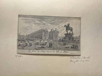
Sold2024'La statue de Henry IV et l'Isle du Palais' Copperplate Engraving, c. 1621France, 17th century. A copperplate engraving by Israel Silvestre (1621-1691). On lined paper with a watermark, partially of a heart. Exact copies held by the Royal Collection Trust and the Louvre. MSee Sold Price
Sold2024Antique Hunting Copperplate EngravingContinental, possibly 17th century. A copperplate engraving, having been made in with lines. Pasted onto lined paper with an embossed crest. 5 x 3.25 inches (plate) 7.5 x 8.5 inches (total)See Sold Price
Jun 01Link Auction GalleriesAfter Jusepe De Ribera, Naples, Italy 17th century, 17th c. Old Master Drawing of the Mourning of$150