Sold20161936 Illustrated Map of Peiping (Beijing) in EnglishColonel Frank Dorn (American, 1901-1981), Illustrated map of Beijing or Peking, China, published in Tientsin-Peiping, China by Peiyang Press, 1936. Representing the golden age of pictorial maps, an icSee Sold Price
Sold2022Dorn, Frank, A Map And History Of Peiping, 1936Type: Pictorial mapMaterials: PaperMarkings & Inscriptions: UnmarkedDate: 1936Maker: Peiyang Press Ltd., 1936.Description: An illustrated hand colored chromolithographic map of Peiping (Beijing) by CoSee Sold Price
Sold2018* Dorn, Frank, TienTsin-Peiping: The Peiyang Press,* Dorn, Frank, TienTsin-Peiping: The Peiyang Press, Ltd., 1936 map, framed. 33 3/4 x 29 5/8 inches. Estimate $500-700 Property from the Estate of Ms. Ruth Ann Koesun, Chicago, IllinoisSee Sold Price
Sold2017Vintage Artwork Framed Map of Short Hills, NJVintage 1936 illustrated map of the town of Short Hills, New Jersey. Framed and matted, possibly hand-drawn, possibly hand-painted. Measures 17 inches H x 20 inches H.See Sold Price
Sold2016Coast of South Carolina (Great Naval Expedition), 1861Original wood engraving from Frank Leslie's Illustrated Newspaper, November 23, 1861. Map is of Port Royal and naval & military operations of the Great Naval Expedition of Commodor DuPont & General ShSee Sold Price
Sold20211861 MAP OF COAST OF SOUTH CAROLINAOriginal 1861 Frank Leslies Illustrated News Coast of South Carolina Wood Engraving with later hand coloring. Professionally framed. In frame measures 28"x31"x1". Weight 9 pds. NO IN HOUSE SHIPPING. PSee Sold Price
Sold20231936 Complete Illustrated Big Game Fish MapXL Big Game Fish Complete Map, Illustrated Fresh and Salt Water fishing. Marked on bottom. Designed and copyright by Joe. Godfrey JR…Chicago. Number 105. Map depicts the whole of the U.S.A with an iSee Sold Price
Sold20221876 Frank Leslies Register, Posters, Maps etc1876 Frank Leslies Illustrated Historical Register Centennial Exposition Plus Folded War Bonds Poster, Rolled Maps, etc. -See Sold Price
Sold2023The Sea Fairies by L. Frank Baum, RareRare hardcover copy of The Sea Firies by L. Frank Baum. Illustrated by John R. Neill. Published by Reilly & Lee Company, no date. Interior inscribed by previous owner, dated 1936. Wear to cover, spineSee Sold Price
Sold2021SCARCE OZ BOOK"Tik-Tok of Oz" by L. Frank Baum, Illustrated by John R. Neill, Reilly & Britton Co. Chicago, 1914. Green cloth binding with black title on spine, applied full front board illustration, map of Oz on eSee Sold Price
Sold20201878 Frank Leslie Panorama of Virginia City, NV.Historic Maps 1878 Panorama Fold-Out View of Virginia City, Nevada March 2, 1878-Dated Issue "Supplement Gratis with No. 1,170 of Frank Leslie's Illustrated Newspaper," Huge Size, Special Fold-Out PanSee Sold Price
Sold2020Rare pictorial map of Peking 1936Heading: (China - Beijing) Author: Dorn, Frank Title: A Map and History of Peiping, formerly known as Peking... Place Published: Tienstsin-Peiping Publisher:Peiyang Press, Ltd. Date Published: </See Sold Price
Sold2023[McMURTRY, Larry (1936-2021), his copy]. GRAVES, Robert (18...[McMURTRY, Larry (1936-2021), his copy]. GRAVES, Robert (1895-1985). Goodbye to a River. [Austin: W. Thomas Taylor for] The Book Club of California, 1989. 4to. Illustrated with foldout map and from phSee Sold Price
Sold2016A Natural History of the Ducks by John C. PhillipsFour volumes, 1922-1926, 264, 409, 383, 409 pages respectively, illustrated with black and white maps, plates, including 72 color plates of artwork from Frank W. Benson, Allan Brooks and Louis AgassizSee Sold Price
Sold2022VARIOUS ARTISTS. [ILLUSTRATED MAPS]. Group of 3 posters. 1930s-1940s. Sizes vary.VARIOUS ARTISTS [ILLUSTRATED MAPS]. Group of 3 posters. 1930s-1940s. Sizes vary. Condition varies, generally A- / A. Group includes: A Map of Western Long Island (1939), by Rolf Klep; Michigan / UpperSee Sold Price
Sold2022(PICTORIAL MAPS.) Charles Turzak & Henry Chapman. An Illustrated Map of Chicago • Youthful(PICTORIAL MAPS.) Charles Turzak & Henry Chapman. An Illustrated Map of Chicago • Youthful City of the Big Shoulders • Restless • Ingenious • Wilful • Violent • ProSee Sold Price
Sold2018J. P. Pinchon, illustrated map of France c. 1951J. P. Pinchon, illustrated map of France c. 1951, Joseph Porphyre Pinchon (French, 1871-1953), partially completed map of France, c. 1951, watercolor and oil on paper mounted on linen, unframed, whimsSee Sold Price
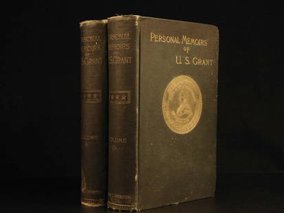
Sold20241885 Civil War 1ed Memoirs of Union General Ulysses S. Grant Illustrated MAPS 2v1885 Civil War 1ed Memoirs of Union General Ulysses S. Grant Illustrated MAPS 2v “The art of war is simple enough. Find out where your enemy is. Get at him as soon as you can. Strike him as hard asSee Sold Price
Sold2021Dutch Nicolaes Visscher I Map of New Amsterdam, ca 1690Nicolaes Visscher I. Map of Northeast with Early View of New York City. Ca. 1690 to 1729. A finely hand-colored example of Nicolaes Visscher I's illustrated map of the Northeast of America with an insSee Sold Price
Sold2023Original Vintage Indochine Francaise Map by Lucien Boucher 1935 Vietnam Laos CambodiaAs one can only imagine, travel in the Far East in the 1920's must have been a challenging adventure. This well illustrated map poster by master artist, Lucien Boucher shows the various routes once coSee Sold Price
Sold20181885 1ed Civil War Memoirs Union General Ulysses Grant1885 1ed Civil War Memoirs Union General Ulysses S Grant Illustrated MAPS 2v “The art of war is simple enough. Find out where your enemy is. Get at him as soon as you can. Strike him as hard as youSee Sold Price
Sold20201756 Gulliver’s Travels Jonathan Swift English Classic1756 Gulliver’s Travels Jonathan Swift English Classic Illustrated Maps FAMOUS “Every man desires to live long, but no man wishes to be old.” ― Jonathan Swift, Gulliver’s Travels JonathaSee Sold Price
Sold20212 vols. Frank Leslie's Illustrated Newspaper.[Civil War] Frank Leslie's Illustrated Newspaper. 2 volumes. Folio. Quarter leather over maroon boards, gilt. Containing the Years June 2, 1860 to Dec. 28, 1861; April 25, 1863 to October 8, 1864. ConSee Sold Price
Sold20241865 HISTORY of INDIAN WARS in NEW ENGLAND 2 volumes ILLUSTRATED w/ MAP antiqueThe History of The Indian Wars in New England from the First Settlement to the Termination of the War with King Philip, in 1677. by William HUBBARD (1621?-1704) Roxbury, Mass.: printed for W. Elliot WSee Sold Price
Jun 02Schilb Antiquarian Rare Books1903 WIZARD of OZ Frank Baum Illustrated Denslow Fantasy Childrens Literature$185(5 bids)
2 days LeftClark's Auction CompanyThe Works Of Rabelais, Illustrated Frank C. Papé, 1927 Hand Numbered Limited Edition$60
6 days LeftNY Elizabeth ERNEST FLOYER'S 1882 UNEXPLORED BALUCHISTAN ANTIQUE MAP ILLUSTRATED IN ENGLISH$50
Jun 23Schilb Antiquarian Rare Books1908 American Fairy Tales L Frank Baum Oz Illustrated Children Stories RARE$66(3 bids)
Jun 14DuMouchellesFrank Stella (American, B. 1936) Lithograph, Etching, Aquatint And Relief Printed in Colors, Ca.$2,250(1 bid)
6 days LeftBonhamsFRANK STELLA (NE EN 1936) Spectralia from Imaginary Places, 1995 (Axsom and Kolb, 226)Lithograp...€2,500
Jun 05Lion Heart AutographsConchita Supervia’s Last Words from Her Personal Notebook Calendar$400
20 hrs LeftCain Modern AuctionsDouble Sided U.S. Map by Rand McNally, Illustrated & Equal Area Projection$75
Jun 04DOYLE Auctioneers & AppraisersLouis XVI Gilt-Bronze Mounted Mahogany Bonheur du Jour 18th Century$1,000
Jun 02Schilb Antiquarian Rare Books1939 WIZARD of OZ Baum Illustrated MGM MOVIE ed Judy Garland FAMOUS$84(3 bids)
Jun 23Schilb Antiquarian Rare Books1903 WIZARD of OZ Baum Illustrated Denslow Fantasy Childrens Literature Color$20(4 bids)
Jun 06Freeman's | HindmanFAULKNER, William (1897-1962). Absalom, Absalom! New York: Random House, 1936.$300


![[McMURTRY, Larry (1936-2021), his copy]. GRAVES, Robert (18...: [McMURTRY, Larry (1936-2021), his copy]. GRAVES, Robert (1895-1985). Goodbye to a River. [Austin: W. Thomas Taylor for] The Book Club of California, 1989. 4to. Illustrated with foldout map and from ph](https://p1.liveauctioneers.com/928/295567/157314291_1_x.jpg?height=310&quality=70&version=1689365279)

![VARIOUS ARTISTS. [ILLUSTRATED MAPS]. Group of 3 posters. 1930s-1940s. Sizes vary.: VARIOUS ARTISTS [ILLUSTRATED MAPS]. Group of 3 posters. 1930s-1940s. Sizes vary. Condition varies, generally A- / A. Group includes: A Map of Western Long Island (1939), by Rolf Klep; Michigan / Upper](https://p1.liveauctioneers.com/199/255737/132982810_1_x.jpg?height=310&quality=70&version=1658424802)


![2 vols. Frank Leslie's Illustrated Newspaper.: [Civil War] Frank Leslie's Illustrated Newspaper. 2 volumes. Folio. Quarter leather over maroon boards, gilt. Containing the Years June 2, 1860 to Dec. 28, 1861; April 25, 1863 to October 8, 1864. Con](https://p1.liveauctioneers.com/179/209052/106367304_1_x.jpg?height=310&quality=70&version=1624651037)


![[JAPAN] KIMBEI, KAZUMASA, BEATO, STILLFRIED. 7 (1 of 8)](https://p1.liveauctioneers.com/8124/329546/177689858_1_x.jpg?height=282&quality=70&version=1715469494)


