Sold2020Antique Adams Syn Chronological Map of HistoryAntique Adams Syn Chronological Chart or Map of History Book of Oversized Coated Color Illustrated Cloth Continuous Map of the World with History , Dated 1884. Fifth edition by Colby & Co. Publishers,See Sold Price
Sold2023Sebastian C. Adams - Synchronological Chart, Illustrated Panorama of History, Chronological Chart ofLot 56 Sebastian C. Adams American (1825-1928) Synchronological Chart, Illustrated Panorama of History, Chronological Chart of Ancient Modern and Biblical History with Maps , Group of 3 (1884) chromoSee Sold Price
Sold2024Adams' Synchronological Chart Or Map Of History, John E. Colby, Colby & Company, 1880Adams' Synchronological Chart Or Map Of History, John E. Colby, Colby & Company, 1880. Includes Chart & Key. Chart (folded) approximately 28.25L x 14.0W x 0.75D in. Key approximately 6.5H x 4.See Sold Price
Sold2021Adams Synchronological Chart or Map of HistoryAdams Synchronological Chart or Map of History.See Sold Price
Sold2022Adams Syn Chronological Chart/ Map of History, 1976Description: Adams Syn Chronological Chart or Map of History, 1976, printed by 'Strobridge & Co. Lith. Cincinnati, O.', copyright 1876 'Centennial Edition', a chronological chart of ancient, modeSee Sold Price
Sold2022History of Civilization 4 Panel Decoupage ScreenAdams syn chronological chart of map of history. Closed screen measures approx 66H x 17W inches. Wear to piece consistent with use and age. Some peeling of paint and scratches to piece. Screen, room dSee Sold Price
Sold2016Vintage Adams Map of History BookAdams Map of History book. Vintage reproduction of the famous illustrated time line of earth's history, 1st published in 1871. Hard cover. 13" W x 27 1/2" H.See Sold Price
Sold2024ADAMS SYN CHRONOLOGICAL CHART PUBLISHED BY COLBY & CO. NY 19TH CENTURY FOLDS OUT TO TWENTY FEET 28" X 20' PLEASE READ CAREFULLY - Terms for Purchasing and Shipping of Auction Items. Please read carefully before bidding. All paymenSee Sold Price
Sold2021Set 8 of School Charts - Texas History and ResourcesSet 8 of Vintage School Charts Maps - Texas History and Resources36 in tall x 45 x 1 - Denoyer - Geppert of Chicago / J. L Clark & Lewis W. NewtonSee Sold Price
Sold2018William Howard Russell THE BRITISH EXPEDITION TO THEWilliam Howard Russell THE BRITISH EXPEDITION TO THE CRIMEA 1877 Folding Maps/Charts History Crimean War Siege Sevastopol Charge Light Brigade Russia Ottoman Empire Balkans Alma Treaty of Paris Title:See Sold Price
Sold2021United States History - Synchronic ChartsUnited States History with Synchronic Charts Maps and Statistical Diagrams. History Made Visible - National Edition. Large colar folding chart. Few written pages of notes.See Sold Price
Sold20221893 1ed ALASKA Inuit ESKIMOS Maps GOLD Mining America Population & History1893 1ed ALASKA Inuit ESKIMOS Maps GOLD Mining America Population & History In 1884, the United States named the Alaskan territory the District of Alaska, and while Alaska wouldnt become a state for mSee Sold Price
Sold2024Goode, George Brown 1884 Lot of 4 Natural History & Meteorology MapsIncl River Basins of the Atlantic Slope, World showing distribution on the Hair Seal Family, Ditto the Walruses/Seals/Sea Lions and Sea Elephants, and influence of Hydro-Thermals of the Migration of SSee Sold Price
Sold2017Wilkinson: Antique Text Map of Empires of World, 18141814 Map/Text Map of Empires of the World by Wilkinson. Fascinating and unusual chart/map showing the great empires and nations in man’s history. Vertical sections depict each century starting beforSee Sold Price
Sold2024William Hole "A Description of the land of Gosen, and Moses passage though the Deserts"Map from Raleigh's History of the world 1652. This map charts the legendary journey of Moses, leading the Israelites out of Egyptian captivity. It depicts their escape route, including the dramatic paSee Sold Price
Sold20201884 20 Years of Congress, Civil War History, Map 1st1884 Senator James Blaine Twenty Years of Congress, 1861 to 1881 1st Edition POWERFUL with foldout map of America from 1819 21.5x15 at rear of volume 1See Sold Price
Sold20191884 BEAUTIFUL 9v Appleton American Cyclopaedia World1884 BEAUTIFUL 9v Appleton American Cyclopaedia World History Maps In the late 19th-century, the Appleton publishing company printed an enormous multi-volume encyclopedia of American biography. This sSee Sold Price
Sold2016AE Hall Great War Illustrated Photos Maps Charts 1History And Rhymes Of Lost Battalion Beck Pvt. McCollum, Stories Of Americans in World War Charles Merrill Co. Publisher William Allen. 3 PiecesSee Sold Price
Sold20187V History Books DECORATIVE ANTIQUE BINDINGS Gilt7V History Books DECORATIVE ANTIQUE BINDINGS Gilt Leather Marbled Paper Girondists Lamartine Oeuvres Volney Folding Maps Tables Charts Memoirs Duke Sully English History Ancient Book Details: This grSee Sold Price
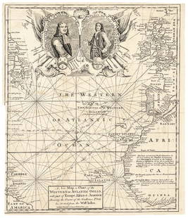
Sold20171740 Ornate Copperplate Engraved Portrait MapHistoric Maps 1740 Ornate Copperplate Engraved Map with Portraits of British Admirals “Robert Blake” & “Edward Vernon, Esq.” 1740-Dated, Copperplate Engraved Map titled “A New Map or Chart oSee Sold Price
Sold2021Sebastian C. Adams. A Chronological Chart of Ancient,Sebastian c. Adams (1825-1928 - Salem, OR). A Chronological Chart of Ancient, Modern and Biblical History. Teaching Scroll Inside Original Frame & Glass. Rare 1800's Wall Chart. Time-Line Chart Of HisSee Sold Price
Sold2019Hurlbut’s Manual of Biblical Geog., 1884First thus. Wonderful survey of the geography of the bible with full-color plates including 2-pg Chart of Bible History, 2-pg The Old Testament World, Journeys of the Patriarchs, Lands of the SojournSee Sold Price
Sold2021Scarce Genealogical h/c chart from Creation to Saul,Large format, two-page foldout tracing Creation to the first king of Israel. Shown in blocks of period hand-coloring for clarity. Genealogical, Historical and Chronological Map of SACRED HISTORY, fromSee Sold Price
Sold20191884 Early History of Illinois Breese French1884 Early History of Illinois Breese French Exploration Americana MAPS Indians “The Early History of Illinois” is a late 19th-century account of the settlement and exploration of the state of IllSee Sold Price
Jun 08Early American History Auctionsc 1797 JOHN ADAMS, President of the United States of America. Historical Liverpool Creamware Pitcher$2,000
BonhamsIRELAND - MANUSCRIPT PEDIGREES Two Manuscript pedigrees of the Bolton family of Mount Bolton, Wa...£550
BonhamsPYNE (WILLIAM HENRY) The History of the Royal Residences of Windsor Castle, St. James's Palace, ...£1,600
BonhamsACKERMANN (RUDOLPH) The History of the Abbey Church of St. Peter's Westminster, its Antiquities ...£400
Jun 08Early American History Auctions1720 Colonial Northumberland County Virginia Manuscript Deed and Map Plot$400
Jun 08Early American History Auctionsc 1797 Extremely Rare JOHN ADAMS President of the United States, Liverpool Creamware Bowl Choice EF$2,400
Jun 08Early American History Auctions1853 Specialized Map, Railroads in the United States in Operation and Progress... Treasury Deptment$200(1 bid)
Jun 08Early American History Auctionsc. 1900 CUSTERS LAST FIGHT Massive Color Lithograph Version after Cassilly Adams, Framed 40 x 30 In.$350
Jun 08Early American History AuctionsDAVID G. FARRAGUT, Rear Admiral, Letter Signed March 23, 1863 from U.S. Flag Ship Hartford$650
Jun 08Early American History Auctionsc 1730 Hand-Colored Colonial Era Map of the Americas, California shown as an Island, Matted + Framed$500(1 bid)
Jun 08Early American History AuctionsLot of Miscellaneous Printed Articles and Reproduction Souvenier Continental Army USA Design Buttons$100
Jun 08Early American History AuctionsWENDELL PHILLIPS Signed Cabinet Card Photo the Abolitionist and Womens Rights Advocate$180
Jun 08Early American History Auctions1776 Map, PARTIE ORIENTALE DU CANADA, AVEC LA NOUVELLE ANGLETERRE, L'ACADIE... by P. Santini, Framed$950
Jun 08Early American History Auctions1836 Hand-Colored Map, Country Twenty Five Miles Round The City Of New-York Published by D.S. Stone$260
Jun 08Early American History Auctions1825 JAMES MONROE Headed yet Signed by J. Q. Adams as President, Rare Re-use Document,$1,500
Jun 08Early American History Auctions1861 Civil War Adams Express $50,000 U.S. Govt. Business Bond at Port Royal, SC.$150
Jun 08Early American History Auctions1753 Map of the County of Lancaster Divided into its Hundreds, by Royal Mapmaker Emanuel Bowen$280
Jun 08Early American History Auctions1853 Map, Basin of the St. Lawrence, by T. Keefer showing Natural + Artificial North American Routes$220