Sold2022British Isles.- Ortelius (Abraham) Britannicarum Insularum Vetus Descriptio, two-sheet map ofBritish Isles.- Ortelius (Abraham) Britannicarum Insularum Vetus Descriptio, two-sheet map of ancient Britain, probably engraved by Jan Wierix, with four ornate strap-work cartouches, a naval battle iSee Sold Price
Sold20221871 Alfred the Great King of England MAP Battle of Ashdown Vikings Thom Hughes1871 Alfred the Great King of England MAP Battle of Ashdown Vikings Thom Hughes Alfred the Great was one of the most powerful and influential English kings of medieval Great Britain. King of Wessex inSee Sold Price
Sold2023Britains #41106 U.S. Leaders SceneWorld War One Officers review map as they plan their battle strategy. 7 pieces. Mint condition. Box excellent.See Sold Price
Sold2020Britains #41106 U.S. Leaders SceneWorld War One Officers review map as they plan their battle strategy. 7 pieces. Excellent condition. Box excellent.See Sold Price
Sold202118th-19th C. Botanical and Nautical printsincludes 4 Botanical plates 1790's by W. Curtis a 19th C. Map of France, Mitchell, 1847. Battle of Trafalgar, October 21st 1805, from 'The Naval Achievements of Great Britain' by James Jenkins, engravSee Sold Price
Sold2022Rare First American Revolutionary War Battle MapAmerican Revolution First American Printing Of A Revolutionary War Battle Map "A View of the Present Seat of War, at and near New-York." 1777-Dated (Printed 1776) Revolutionary War Period, Printed MapSee Sold Price
Sold2023First American Revolutionary War Battle Map, from Nathan Daboll, Freebetter's New-England Almanacks,American Revolution First American Printing of a Revolutionary War Battle Map Titled: "A VIEW of the Present Seat of War, at and near New-York." by Nathaniel Low, Printed by John Gill, Boston 1777-DatSee Sold Price
Sold20211777 1st American Rev War Battle Map: SEAT of WARAmerican Revolution First American Printing Of A Revolutionary War Battle Map "A View of the Present Seat of War, at and near New-York." [1776] Revolutionary War Printed, First American printed RevoluSee Sold Price
Sold2017PAIR OF VINTAGE BATTLE MAP HAND COLORED ENVRAVINGSPAIR OF VINTAGE BATTLE MAP HAND COLORED ENGRAVINGS. Height: 28 & 22 in. by Width: 40 1/2 & 34 1/2 in.See Sold Price
Sold20201702 battle map of Germany around Rhine and MoselleTitle: 1702 battle map of Germany around Rhine and Moselle region, 1762 by Homann Heirs Date/Period: 1762 Materials: Copper plate engraved Size: 24 x 20 1/2" Description: 1762, by J. B. Homann & HomanSee Sold Price
Sold2020SET of 5 WWI 4th DIV. BATTLE MAP s, w PERSHING LETTERSET of 5 WWI 4th DIV. BATTLE MAP s, w PERSHING LETTER VESLE TOULON MEUSE ARGONNE SET of 5 WWI 4th DIV. BATTLE MAP s, w PERSHING LETTER VESLE TOULON MEUSE ARGONNE Description WWI 4th DIVISION - AMERICASee Sold Price
Sold2018Group of Five U.S. Army Battle Maps of Okinawa, Japan.[WWII] Group of Five U.S. Army Battle Maps of Okinawa, Japan. Army Map Service, 1945. Printed reference maps prepared “For use by War and Navy Department Agencies Only”. Includes air traffSee Sold Price
Sold202018th c. Battle Map18th c. Battle map "PLAN / of the ACTION of / HUBERTON...July 1777". Sight 11" x 13 1/2".See Sold Price
Sold2022Antique Prints including Gettysburg Battle Map. 28Antique Prints including Gettysburg Battle Map. 28 piece grouping of antique engravings and illustration prints. Featuring a unique circular recreation of the American Civil War Battle of Gettysburg,See Sold Price
Sold202319th C. Mexican American War Battles Map + Litho**Originally Listed At $200** Kelloggs & Thayer (American, 19th century). "Resaca de la Palma. Battle of May 9th 1846." Color lithograph. Publishing Firm: E.B. & E.C. Kellogg, Hartford, Connecticut; PSee Sold Price
Sold2023WWII Japanese Propaganda Leaflets And A Korean Battle MapWWII Japanese Propaganda Leaflets And A Korean Battle Map. Please carefully read our terms of sale, shipping information, and request any condition reports or photos prior to placing a bid. Any conditSee Sold Price
Sold2020Salute to the Brave The Battle Britain FDC multi SignedSalute to the Brave The Battle Britain FDC multi Signed 16 veteran signatures includes Rod Learoyd, Air Cmr A Winskill, Ralph Wolton, Ludwik Martel, Eric Barwell, Wg Cmr Doe and Ken Farrow. WW2 RAF BaSee Sold Price
Sold2022French Battle Map 1710A French battle map of the ‘Plan du champ de Bataille pour L'Armée des Hauts Alliés entre Vitry et Montigny le 28 May 1710.’ The map is saran wrapped to a board. Dimensions are: sigSee Sold Price
Sold201619thc Battle Map, Second Manassas, Bull RunOriginal 19thc Battle Map, Plan no.7, by Hugh Rees, Ltd. Battle of Second Manassas or, Second Bull Run. August 30, 1862. Federals, 65,00 ( Pope ). Confeds., 50,000 ( Lee ). Shows the unfinished railroSee Sold Price
Sold2021Greig, G. R. 1858 Lot 4 Wellington Battle Maps. SpainAlso Portugal. Steel Engraved Map Published 1858, London for "History of the Life of Arthur Duke of Wellington" by the Rev. G. R. Gleig. Folds as issued. Paper Size: Up to 10.5 x 8.5 inch (27 x 20cm)See Sold Price
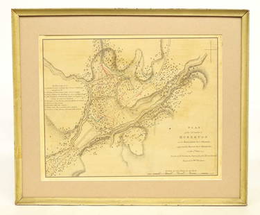
Sold2022Battle Map Engraved by Andrew Bell.Andrew Bell (1726-1809). 6.75 x 9 inches, sight. Andrew Bell was co-founder of the Encyclopedia Britannica, and produced nearly all engravings for the first four editions of the publication.See Sold Price
Sold2020Battle Britain softback book titled Their Finest HourBattle Britain softback book titled Their Finest Hour the Story of the Battle of Britain 1940 by Edward Bishop. The Pan Ballantine Illustrated History of World War Two. 160 pages. Good Condition. We cSee Sold Price
Sold2021Greig, G. R. 1858 Lot 4 Wellington Battle Maps. SpainSteel Engraved Map Published 1858, London for "History of the Life of Arthur Duke of Wellington" by the Rev. G. R. Gleig. Folds as issued. Paper Size: Up to 11 x 9 inch (28 x 23cm) Very minor toning.See Sold Price
Jun 02Schilb Antiquarian Rare Books1871 Alfred the Great King of England MAP Battle of Ashdown Vikings Thom Hughes$125(3 bids)
Jun 09Worthington Galleries1705 Map LE COMBAT DE STEENKERKE [Battle of Steenkerque] by Nicolas de Fer$10
3 days LeftCedarburg Auction & Appraisals LLCSet of Four 17th Century Maps Showing All of Spain and Portugal$375(2 bids)
2 days LeftJasper521723 Dampier Map of Voyages to Brazil, Australia and Eat Indies -- Voyage du Cap. Dampier a la N.$280
Jun 08Early American History Auctions1753 Map of the County of Lancaster Divided into its Hundreds, by Royal Mapmaker Emanuel Bowen$280
Jun 04TimeLine Auctions Ltd.Stone Age Scandinavian Type Lozenge-Shaped Pierced Battle Axehead£5(1 bid)
Jun 08Simpson Galleries, LLC.JODOCUS HONDIUS (1563-1612) A JACOBEAN MAP, "Northamptonshire," AMSTERDAM, 1610$150
5 days LeftFreeman's | Hindman[CIVIL WAR]. Archive of items related to Elisha Hunt RHODES (1842-1917), 2nd Rhode Island Volunteer$750


![1777 1st American Rev War Battle Map: SEAT of WAR: American Revolution First American Printing Of A Revolutionary War Battle Map "A View of the Present Seat of War, at and near New-York." [1776] Revolutionary War Printed, First American printed Revolu](https://p1.liveauctioneers.com/218/230033/119008047_1_x.jpg?height=310&quality=70&version=1639440290)


![Group of Five U.S. Army Battle Maps of Okinawa, Japan.: [WWII] Group of Five U.S. Army Battle Maps of Okinawa, Japan. Army Map Service, 1945. Printed reference maps prepared “For use by War and Navy Department Agencies Only”. Includes air traff](https://p1.liveauctioneers.com/928/124137/63148928_1_x.jpg?height=310&quality=70&version=1530051387)


![1705 Map LE COMBAT DE STEENKERKE [Battle of Steenkerque] by Nicolas de Fer (1 of 1)](https://p1.liveauctioneers.com/6084/330420/178181962_1_x.jpg?height=282&quality=70&version=1716391551)
![[MAP]. ORTELIUS, Abraham. Africae Tabula Nova. 1592. (1 of 2)](https://p1.liveauctioneers.com/197/329395/177650533_1_x.jpg?height=282&quality=70&version=1715364962)


![[CIVIL WAR]. Archive of items related to Elisha Hunt RHODES (1842-1917), 2nd Rhode Island Volunteer (1 of 6)](https://p1.liveauctioneers.com/197/329785/177758366_1_x.jpg?height=282&quality=70&version=1715625218)