Sold2022Early Hand Drawn Map of United States in 1817,by Mary Young, image area 20" X 30" plus frame.See Sold Price
Sold2021Artwork LotLot including early hand drawn maps (largest 14" x 16"), floral watercolor (20" x 12 3/4"), painting on panel marked LRC "LT Keeler Kimpo Korea '53" (12 1/4" x 16 1/4").See Sold Price
Sold2023Loaded Lot of Early Advertising Therms, Hand Drawn Maps, Farm Dealer Manuals and MoreThis lot is loaded with early advertising including Fordson, International, John Deere and MoreSee Sold Price
Sold202219th Century Hand-Drawn Map of NY, PA, MD, NJ, DEHistoric Maps 19th Century Original Hand-Drawn Regional Map of New York, Pennsylvania, Maryland, New Jersey, and Delaware 19th Century Hand-Drawn Regional Map of New York, Pennsylvania, Maryland, NewSee Sold Price
Sold2022[MANUSCRIPT MAP-MAINE] After DES BARRES, JOSEPH FREDERICK WALLET. Hand-drawn map of a portion of the[MANUSCRIPT MAP-MAINE] After DES BARRES, JOSEPH FREDERICK WALLET. Hand-drawn map of a portion of the Maine coast off Falmouth, copied from Des Barres. Likely early 19th century. Manuscript map in blacSee Sold Price
Sold2020Early 19th Century Map of VermontHAND DRAWN, COLORED MAP OF VERMONT BY ESTHER CONKEY OF ORWELL OCT 22 1825 ON PAPER 21"X17" LINEN BACKED TORN THRU CENTER OF MAP WITH SOME LOSSES, TAPE RESIDUE,TONING AND SPOTTING - IMPERFECTIONSee Sold Price
Sold2016Map of Asia. J. Russell.From The Compendious Geographical Dictionary Maker: Russell, J. Origin: London, 1795. Medium: Engraving with early hand-coloring. Sheet size: 5 x 6 1/2 in. No Reserve: This lot starts at $1 and has noSee Sold Price
Sold2015EARLY MAPS OF SKOWHEGAN AND MADISON, MAINEEARLY MAPS OF SKOWHEGAN AND MADISON, MAINE Early hand-drawn and colored map of Skowhegan, Maine, 15 1/2" x 12 1/2", a copy of a 1790 map executed in Boston, Feb. 2, 1791and showing the Kennebec and SaSee Sold Price
Sold2021LATE 19TH & EARLY 20TH C. KANSAS MAPS LOT OF 6LATE 19TH & EARLY 20TH C. KANSAS MAPS LOT OF 6 Lot of late 19th and early 20th century maps of Kansas. Includes 5 Hand drawn and hand colored maps from the 1880s. Fort Scott, Eldorado, Emporia, SalinSee Sold Price
Sold20231700s MAP of ASIA MINOR ARMENIA SYRIA SYCILY PERSIA antiqueMap of Asia Minor early 18th century hand colored Size 14 1/2 by 18 3/4" Very good condition Reserve: $160.00 Shipping: Domestic: Flat-rate of $25.00 to anywhere within the contiguous U.S. InternaSee Sold Price
Sold2021Large hand colored map of Asia, 1875Large vintage map of Asia in the not-often seen hand-colored version. Most likely drawn by A. K. Johnston, and appearing the very scarce Jones and Hamilton Atlas of the World Illustrated, published 18See Sold Price
Sold2022(ON-19) EARLY TRAIL OF TEARS EPHEMERA DOCUMENTS CHOCTAW NATIONEarly 19th collection of documents that includes two maps. The group with no odors and in clean condition. 1) A map with cover note that is hand drawn and lightly colored showing vacant landsaround deSee Sold Price
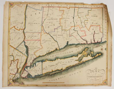
Sold2023EARLY CONNECTICUT MAPHand drawn and colored; "Connecticut and Parts Adjacent", "drawn by Miss. Elizabeth L. Tredwell" "Christ Church Academy 1820", several edge tears; 23" x 30", F-GSee Sold Price
Sold2021Tallis, John (Pub) 1852 Map. Asia ContinentSteel Engraved Map with Original Outline Hand Color Published 1852-56 by John Tallis, London for "The Universal Pronouncing Dictionary" by Thomas Wright. Drawn & Engraved by John Rapkin. Centre fold aSee Sold Price
Sold2021Tallis, John (Pub) 1852 Map. AsiaSteel Engraved Map with Original Outline Hand Color Published 1852-56 by John Tallis, London for "The Universal Pronouncing Dictionary" by Thomas Wright. Drawn & Engraved by John Rapkin. Centre fold aSee Sold Price
Sold2021Tallis, John (Pub) 1852 Map. Asia MinorSteel Engraved Map with Original Outline Hand Color Published 1852-56 by John Tallis, London for "The Universal Pronouncing Dictionary" by Thomas Wright. Drawn & Engraved by John Rapkin. Centre fold aSee Sold Price
Sold2024Clarke & Russell 1814 Hand Col Map. AsiaHand Colored Copper Engraved Map Published 1814-27, London for "A New Geographical Dictionary; Containing a Description of all the Empires, Kingdoms, States and Provinces..." by J. W. Clarke. Drawn anSee Sold Price
2021Tallis, John (Pub) 1852 Map. Asia ContinentSteel Engraved Map with Original Outline Hand Color Published 1852-56 by John Tallis, London for "The Universal Pronouncing Dictionary" by Thomas Wright. Drawn & Engraved by John Rapkin. Centre fold aSee Sold Price
Sold2024Russell, J. 1804 Antique Map. AsiaCopper Engraved Map with outline hand color Published 1804 by W. Peacock, London for "A Compendious Geographical Dictionary" Drawn and Engraved by J. Russell. Folds as issued. Paper Size: 6.5 x 5 inchSee Sold Price
Sold2016Map of Asia Minor. 1854.Print of hand colored steel engraving titled „Asia Minor“.Drawn by L. Dussieux.Engraved by unknown.From „Atlas General De Geographie physique, politique et historique par L. Dussieux. Atlas de GSee Sold Price
Sold2022Hand drawn Ottoman AtlasThis hand drawn, Ottoman, Memalik-i Osmaniye Atlas is a rare find. The 72 maps show the Provinces, Sanjaks, Post and Railways, Beaches, Forests and Straits of the Ottoman Empire in Asia, Europe and AfSee Sold Price
Sold2016Map of Asia. 1854.Print of hand colored steel engraving titled „Carte Physique & Politique de L’Asie“.Drawn by L. Dussieux.Engraved by unknown.From „Atlas General De Geographie physique, politique et historiqueSee Sold Price
Sold2023F. Gray's Idaho, Montana and Wyoming Map 1870Featured in this lot is an excellent, hand-colored early map of Idaho Territory, Wyoming Territory and Montana Territory, published by O.W. Gray and drawn by Frank A. Gray. Wyoming is shown with onlySee Sold Price
Sold2021Tallis, John (Pub) 1852 Map. Turkey in AsiaSteel Engraved Map with Original Outline Hand Color Published 1852-56 by John Tallis, London for "The Universal Pronouncing Dictionary" by Thomas Wright. Drawn & Engraved by John Rapkin. Centre fold aSee Sold Price
Jun 08Early American History Auctions1720 Colonial Northumberland County Virginia Manuscript Deed and Map Plot$400
264 Lots AwayJasper52Large Antique French map GERMAN EMPIRE 1792 colored by POIRSON engraver Basset$170
3 days LeftFreeman's | Hindman[CIVIL WAR]. Small archive associated with Lt. Col. William M. Vogelson (1831-1892), 27th Ohio$250
Jun 08Early American History AuctionsDecorative Civil War American School Original Calligraphic Drawing of McClellan Commanding his Staff$1,000
2 days LeftPropstoreTEENAGE MUTANT NINJA TURTLES III (1993) - Hand-Drawn Poster Concept Artwork by Morgan Weistling £250


![[MANUSCRIPT MAP-MAINE] After DES BARRES, JOSEPH FREDERICK WALLET. Hand-drawn map of a portion of the: [MANUSCRIPT MAP-MAINE] After DES BARRES, JOSEPH FREDERICK WALLET. Hand-drawn map of a portion of the Maine coast off Falmouth, copied from Des Barres. Likely early 19th century. Manuscript map in blac](https://p1.liveauctioneers.com/292/250642/130213649_1_x.jpg?height=310&quality=70&version=1654271664)


![[CIVIL WAR]. Small archive associated with Lt. Col. William M. Vogelson (1831-1892), 27th Ohio (1 of 10)](https://p1.liveauctioneers.com/197/329785/177758363_1_x.jpg?height=282&quality=70&version=1715625218)


