Sold2024MAP, St. Petersburg, Daumont Co.St. Petersburg, Russia. Daumont Company, Area Magna Petropolitana / La Grande Place de Petersbourg, 1780 (circa). Hand Color. This striking view depicts a vast street or courtyard in St. Petersburg. VSee Sold Price
Sold2018SDUK: Antique Map of St Petersburg, 1847TITLE/CONTENT OF MAP: 'ST PETERSBURG' DATE PRINTED: 1847 IMAGE SIZE: Approx 34.0 x 40.0cm, 13.25 x 15.75 inches (Large) TYPE: Antique steel engraved map with original outline hand colouring. Inset: PaSee Sold Price
Sold2017SDUK, Map of St Petersburg, 1834Map: Saint Petersburg Maker: Society for the Diffusion of Useful Knowledge (SDUK) Date: 1834 Medium: Engraving Size: 12.75 x 15.25 inches A detailed plan of St Petersburg in 1834 naming most streets aSee Sold Price
Sold2017SDUK: Map of St. Petersburg, 1834St. Petersburg. The meticulously detailed Society for the Diffusion of Useful Knowledge plan of St. Petersburg, Russia, is centered on the Peter and Paul Fortress, with major thoroughfares and publicSee Sold Price
Sold2018Map of St. Petersburg (Petrograd) Reproduction -- PlanyReserve Reduced! Title/Content of Map:Map of St. Petersburg (Petrograd) Reproduction -- Plany Goroda S. Peterburga… [in cyrillic] Date:1894 map - 20th century reprint Cartographer:I Schelanskago SizSee Sold Price
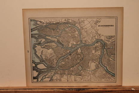
Sold2023Vintage Hand Colored Map of St. PetersburgVintage hand colored map of St. Petersburg. [Map: 13" H x 15" W; Frame: 18" H x 21" W]. Foxing.See Sold Price
Sold2017Maps of St. Petersburg & Edinburgh, 1895Map: 1895 Maps of St. Petersburg and Edinburgh -- St. Petersburg (Russia) [verso] Edinburgh Scotland Year / Place: 1895 Map Dimensions: 9.3 x 12 in. Condition: Very good. Nicely colored. Age toning, mSee Sold Price
Sold20191888 Cram Map of St. Petersburg [verso] Stocholm --St.Title/Content of Map: 1888 Cram Map of St. Petersburg [verso] Stocholm --St. Petersburg (Russia) [verso] Stockholm Date: 1888, Chicago Cartographer: G CramSize: 9.2 X 11.8 in. This is a very nice andSee Sold Price
Sold20201890 Map of St. PetersburgAuthor: Cram Title: 1890 Map of St. Petersburg Medium: Ink on Paper Dimensions: 13.5"X11" Map of St. Petersburg dated 189o. Engraved and published by George Cram in Chicago. Very detailed. Key lower rSee Sold Price
Sold20211900 St. Petersburg MapAuthor: Cram Title: 1900 St. Petersburg Map Medium: Ink on Paper Dimenions: 14.5"X11" Description: Map of St. Petersburg dated 1900. Printed and published by George Cram in Chicago. Part of his WorldSee Sold Price
Sold2019Ca.1869 Keith Johnston St. Petersburg MapCirca 1869 S. Petersburg Map and its Environs by Keith Johnston. Printed by William Blackwood and Sons, Edinburgh and London. Measures 19.375 in. x 24.5 in. Unframed, loose and not mounted or glued doSee Sold Price
Sold2018Sidney Hall: Antique Map Cronstadt & Kotlin Island 1856Title/Content of Map: 'Cronstadt [inset: Environs of St Petersburg]' Kotlin Island Peterhof Date Printed: 1856 Image Size: Approx 27.0 x 22.5cm, 10.75 x 8.75 inches (Medium) Type: Antique atlas map CoSee Sold Price
Sold2022Antique Map - Map of Europe - Russia / Ukraine - Moscow, St. Petersburg, PoltavaAntique map of Russia by Becker, published in London, c 1843. This antique map was engraved by the omnigraph method by Francis Paul Becker & Company, Patentees circa 1842, with contemporary hand colouSee Sold Price
Sold20241794 Map Of The Asiatic Part Of The Russian EmpireThe Asiatic Part of the Russian Empire, from the maps published by the Imperial Academy of St. Petersburg with the new discoveries of Captn. Cook &cSee Sold Price
Sold2021After: Charlemagne "Views St. Petersburg" LithoAfter: Charlemagne European School Hand Colored Lithograph "Views St. Petersburg" Printed by Jacottet and Auburn Paris for Daziaro. Good condition. Measures 12-1/4" x 16-1/4", frame measures 21-1/4" xSee Sold Price
Sold2022(TRAVEL -- ASIA.) John Bell. Travels From St. Petersburg in Russia to Diverse Parts of Asia.(TRAVEL -- ASIA.) John Bell. Travels From St. Petersburg in Russia to Diverse Parts of Asia. Engraved folding map showing the route from Moscow to Beijing with a decorative inset of the Chinese capitaSee Sold Price
Sold2019BALTIC SEA Kronstadt St Petersburg Turku TallinnTITLE/CONTENT OF MAP: 'Baltic Sea' This map is folding hence the centrefold line may show on the image below DATE PRINTED: 1860 IMAGE SIZE: Approx 35.5 x 27.0cm, 14 x 10.5 inches (Large); Please noteSee Sold Price
Sold2017Johnson Map of Florida, 18631863 Johnson Map of Florida -- Johnson's Florida. A nice Johnson map of Florida, showing only 37 counties in the state. The majority of development is in the north with no mention of St. Petersburg orSee Sold Price
Sold2023Northern European Russia with divisions. 1794 by Vaugondy/ DelamarcheTitle: Northern European Russia with divisions. 1794 by Vaugondy/ Delamarche Date/Period: 1794 Materials: Hand colored copper plate engraved. Size: 16 x 11 1/2" Shows cities of St. Petersburg, MoscowSee Sold Price
Sold2016Cody, W.F. Buffalo Bill’s Wild West 1906 European TourCody, W.F. Buffalo Bill’s Wild West 1906 European Tour Print. Single page route foldout map of Europe, measuring 34 x 26.” Map illustrates the 1906 route of Buffalo Bill’s tour of France, Italy,See Sold Price
Sold2023RUSSIAN LANGUAGE BIBLE vintage ILLUSTRATED with MAPSPrinted in New York, no date (c. middle of 20th century) St. Petersburg: Publishing House of V.V. Komarov; 1900 Size 5 1/2 by 7 3/4" Hard bound Very ood condition text in Russian Reserve: $69.00 ShippSee Sold Price
Sold2023U S Coast Survey 1856 Large Map. St. Mary's Bar & Fernandina Harbor Florida"Preliminary Chart of St. Mary's Bar and Fernandina Harbor Florida"Large Lithograph Map Published 1857, Washington for "U.S. Coast and Geodetic Survey" Folds as issued. Paper Size: 25 x 23 inch (64 xSee Sold Price
Sold2016A group of 5 circa 1885 Russian silver open saltsA group of Russian parcel gilt silver open salts, Timothy Hesketh, St Petersburg, circa 1885, the five rounded salts raised on ring feet, the interiors gilded, 84 standard, with European control marksSee Sold Price
Sold2021Encyclo. Britannica C1830 Lot of 4 European MapsIncl Prussia, Denmark, Austrian Dominions and Greece. Steel Engraved Map Published 1830-42, Edinburgh for "Encyclopedia Britannica" Seventh Edition. Centre fold as issued. Paper Size: 16 x 11 inch (40See Sold Price
Jun 08Early American History Auctions1853 Map, Basin of the St. Lawrence, by T. Keefer showing Natural + Artificial North American Routes$220
Featured6 days LeftElmwood'sFABERGE, A RARE JEWELLED GOLD MOUNTED JASPER MODEL OF A HEN, ST PETERSBURG, CIRCA 1900£24,000
Jun 01Black Hills Curio CompanyImperial Russian rings late 1800's Solid Gold .56 and Solid Silver .84$200


![Map of St. Petersburg (Petrograd) Reproduction -- Plany: Reserve Reduced! Title/Content of Map:Map of St. Petersburg (Petrograd) Reproduction -- Plany Goroda S. Peterburga… [in cyrillic] Date:1894 map - 20th century reprint Cartographer:I Schelanskago Siz](https://p1.liveauctioneers.com/5584/130954/66567858_1_x.jpg?height=310&quality=70&version=1542157455)
![Vintage Hand Colored Map of St. Petersburg: Vintage hand colored map of St. Petersburg. [Map: 13" H x 15" W; Frame: 18" H x 21" W]. Foxing.](https://p1.liveauctioneers.com/1221/275442/145469144_1_x.jpg?height=310&quality=70&version=1675222498)
![Maps of St. Petersburg & Edinburgh, 1895: Map: 1895 Maps of St. Petersburg and Edinburgh -- St. Petersburg (Russia) [verso] Edinburgh Scotland Year / Place: 1895 Map Dimensions: 9.3 x 12 in. Condition: Very good. Nicely colored. Age toning, m](https://p1.liveauctioneers.com/5584/105887/54238253_1_x.jpg?height=310&quality=70&version=1498761257)
![1888 Cram Map of St. Petersburg [verso] Stocholm --St.: Title/Content of Map: 1888 Cram Map of St. Petersburg [verso] Stocholm --St. Petersburg (Russia) [verso] Stockholm Date: 1888, Chicago Cartographer: G CramSize: 9.2 X 11.8 in. This is a very nice and](https://p1.liveauctioneers.com/5584/137769/69881360_1_x.jpg?height=310&quality=70&version=1552435690)


![Sidney Hall: Antique Map Cronstadt & Kotlin Island 1856: Title/Content of Map: 'Cronstadt [inset: Environs of St Petersburg]' Kotlin Island Peterhof Date Printed: 1856 Image Size: Approx 27.0 x 22.5cm, 10.75 x 8.75 inches (Medium) Type: Antique atlas map Co](https://p1.liveauctioneers.com/5584/115413/59308629_1_x.jpg?height=310&quality=70&version=1516757305)


