Sold2020French Cartographic Cabinet Plate Map of AmericasA rare cartographic french porcelain plate depicting a map of the Americas. Surrounded by neo classical desings. The porcelain possibly paris porcelain or Sevres blank with incised letters and numbersSee Sold Price
Sold2021Travels in Egypt w/ 59 engraved plates & mapsHeading: Author: Denon, Vivant Title: Travels in Upper and Lower Egypt, in Company with Several Divisions of the French Army, During the Campaigns of General Bonaparte in That Country; and PublishedSee Sold Price
Sold2016Pacific.- Keate (George) Relation des Iles Pelew, 1788.Pacific.- Keate (George) Relation des Iles Pelew, first French edition, half-title, engraved portrait frontispiece, folding map and 15 plates, some folding, minor foxing at beginning and end, contempoSee Sold Price
Sold2023Important colonial period French and Indian war era map centering on the Mississippi River by BellinTitle: Important colonial period French and Indian war era map centering on the Mississippi River by Bellin Date/Period: c1744 Materials: Copper plate engraved Size: 12 x 8 1/2” Important coloniSee Sold Price
Sold2017Carte de La Louisiane by Bourguignon d'Anville"Carte de La Louisiane," by Jean-Baptiste Bourguignon d'Anville (French, 1697-1782) hand-colored copper engraved map, created 1732, published Paris, 1752. Matted, glazed and framed. plate 21" x 36-1/2See Sold Price
Sold2021A REPUBLIC OF TEXAS MAP, "Méxique," THUNOT DUVOTENAY,A REPUBLIC OF TEXAS MAP, "Méxique," THUNOT DUVOTENAY, PARIS, CIRCA 1843, hand-colored lithograph on paper, Thunot Duvotenay, French cartographer, Charles Smith, English plate engraver, a page fragmeSee Sold Price
Sold2019[Map] Virginia and Florida, 17th c.Jannson, Jan. "Virginiae partis australis, et Floridae partis orientalis…." Circa 1640s. Measuring from plate-marks 50.5 x 39cm. Hand-colored. Verso with French text, old stub affixed to crease, andSee Sold Price
Sold2018Covens & Mortier, after del'Isle. Occidental MapAfter Guillaume del'Isle (French, 1675-1726). "Hemisphere Occidental," 1720, with corrections by J. Covens and C. Mortier, hand colored engraving, plate size: 19 1/2 x 19 1/2 in., framed; From the EstSee Sold Price
Sold2017Terrestrial and celestial globesTitle/Content of Map: Terrestrial and celestial globes Date Printed: 1760 Cartographer: Le Rouge, George Size (in): 11 x 9 Antique old French copper-plate engraving ca. 1748 of two globes: a terrestriSee Sold Price
Sold201718th C. French Map w/ Oiled Paper, ex-Sotheby'sEurope, France, map from 1709 CE, oiled paper overlays from 1756 to 1763 CE, owned by Louis-Alexandre Berthier (1753 to 1815 CE), Marshal, Vice-Constable of France, and Chief of Staff (Major general)See Sold Price
Sold2021Antique French Map of MississippiAntique French Map of Mississippi , "Carte Geographique, Statistique et Historique du Mississipi", Paris, Buchon, 1825, sight 21 in. x 27 1/2 in., framed Provenance: Estate of Julia Evans ReedSee Sold Price
Sold2022Haviland Limoges French Plate Set, Imperatrice EugenieHaviland Limoges French plate set in the Imperatrice Eugenie pattern. Floral designs, an ornate trim of gold with a recurring pattern around cavetto of plates. Blue hued, naturalistic depiction of floSee Sold Price
Sold2022Qing Dynasty, "stacked stone Zhai" blue and white landscape map plateH:3.5cm,Diameter:23cmSee Sold Price
Sold2022Qing Dynasty, "Qing Kangxi year" colorful Mu Guiying big break tianmen array map plateH:5cm,Diameter:28.4cm,See Sold Price
Sold2021Antique French Map of United States- Etats-Unis De L'Amerique Septentrionale Avec Les Isles Royale, De Terre Neuve, De St. Jean, L'Acadie &c.; Hand-colored; Ches Boudet Imprimeur du Roi; Paris; undated (circa 1785). One of the early maSee Sold Price
Sold2022Mannevillette French Map of the Indian Ocean, 1753D'APRES DE MANNEVILLETTE, Jean-Baptiste-Nicolas-Denis (1707-1780). [Indian Ocean] Carte Reduite de l'Ocean Oriental depuis le Cap de Bonne Esperance... Engraved map with original hand color in part. PSee Sold Price
Sold20212pc. Lot of French Plate Racks 12"H, 77 1/2" x 42pc. Lot of French Plate Racks 12"H, 77 1/2" x 4 1/2" ea.See Sold Price
Sold20241812 large French map of Paris plan routier de la Ville et faubourgLarge engraving of Paris and its surrounding area dated 1812 , cooper engraving in the manner of the Turgot map ,Jean Pierre printer , a Paris, chez Jean, Rue St Jean de Beauvais, N° 10, It is thSee Sold Price
Sold20221738 Antique French Map of North America1738 Antique French Map of North America, 1783 - Antique Map of North America, with documentation, This map is 221 years old - it is not a modern reproduction or copy, This map comes from: ATLAS DE TOSee Sold Price
Sold201718th Century French Map of North AmericaL’Amerique Septentrionale. Daniel de la Feuille (1640-1709). Engraved map with hand color in full. Amsterdam, 1702 or 1706. 6 x 8 inches visible, 13 x 14 1/2 inches framed. Nicely colored early 18thSee Sold Price
Sold2022c. 1788 French Map of the Eastern United StatesHistoric Maps c. 1788 Map, "Les Etats Unis de L'Amerique Septentrionale, Partie Orientale" (Eastern Part of the Northern United States of America) by M. (Rigobert) Bonne c. 1788 Map titled, "Les EtatsSee Sold Price
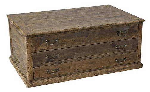
Sold2020Country French Map CabinetThree drawer case in pine with original brass hardware. Drawers pull out from both sides. 49w x 31 1/2d x 20 1/2hSee Sold Price
Sold2023Guillaume De L'Isle Philippe Buache Large Antique French Map of the AmericasImportant map of Guillaume de L'Isle corrected by Philippe Buache and edited by Dezauche in 1800 ,after the conclusion of the American revolutionary war and the treaty of Paris Dezauche updated the neSee Sold Price
Jun 09Worthington GalleriesAntique H/C Map EUROPE SOUS CHARLEMAGNE EN 814: EMPIRES D'OCCIDENT ET D'ORIENT$25
Jun 08Early American History Auctions1753 Map of the County of Lancaster Divided into its Hundreds, by Royal Mapmaker Emanuel Bowen$280
5 days LeftGold Coast Auctioneers17th-19th c. French Wall Art Collection Map City Sea Scapes Scenes etc.$50
Jun 15Crescent City Auction GalleryPair of New Orleans Sanborn Fire Insurance Mock-Up Skeleton Maps of the French Quarter, 1910-1911,$250
13 hrs LeftJasper521771 ASTRONOMY by Joseph M. de La Lande 2 VOLUMES ILLUSTRATED antique in FRENCH$480
BonhamsFRANCE [SEGARD (W.) AND FRANCOIS MARTIN TESTARD] Picturesque Views of Public Edifices in Paris, ...£400
1 day LeftJasper52The Good Samaritan - Original antique engraving after G Freman, 17th century.$65(1 bid)
1 day LeftJasper52Adam and Eve after Their Expulsion from Paradise by Amand-Durand after Lucas van Leyden, 1883$190
1 day LeftJasper52The Baptism of Christ in the River Jordan by Amand-Durand after Lucas van Leyden, 1883$200


![[Map] Virginia and Florida, 17th c.: Jannson, Jan. "Virginiae partis australis, et Floridae partis orientalis…." Circa 1640s. Measuring from plate-marks 50.5 x 39cm. Hand-colored. Verso with French text, old stub affixed to crease, and](https://p1.liveauctioneers.com/3532/146911/74242490_1_x.jpg?height=310&quality=70&version=1564368564)


![Mannevillette French Map of the Indian Ocean, 1753: D'APRES DE MANNEVILLETTE, Jean-Baptiste-Nicolas-Denis (1707-1780). [Indian Ocean] Carte Reduite de l'Ocean Oriental depuis le Cap de Bonne Esperance... Engraved map with original hand color in part. P](https://p1.liveauctioneers.com/1968/250616/130196497_1_x.jpg?height=310&quality=70&version=1654190895)


![FRANCE [SEGARD (W.) AND FRANCOIS MARTIN TESTARD] Picturesque Views of Public Edifices in Paris, ... (1 of 3)](https://p1.liveauctioneers.com/1043/319451/178359213_1_x.jpg?height=282&quality=70&version=1716890505)


