Sold2022Red Mining District Original Map; 1891 [152840]Real, original Map of the Red Mountain Mining District, Ouray County, Colorado. Scale of 1000 ft. to 1 inch. W.A. Sherman M.E. Ouray, Colo. 1891. Printed by Rand McNally & Co. Engravers, Chicago. HasSee Sold Price
Sold2020Rare map of Eureka Mining District, NevadaHeading: (Nevada) Author: Hall, Leon M. Title: Compiled Map Showing Properties of the Eureka Mining District, Eureka County, Nevada Place Published: Eureka County, Nevada Publisher: Date PublisheSee Sold Price
Sold2024Newtown Mining Ledger, 1891 Etc. [174262]1891 Newtown Mining in Inyo county ledger page. 1889 Bullion and Exchange Bank check, small livestock letter in fair condition. Inyo CaliforniaSee Sold Price
Sold2017Wall map of Marin County 1892Heading: (California - Marin County) Author: Dodge, George M. Title: Official Map of Marin County, California 1892 Compiled from Records and Surveys Place Published: San Francisco Publisher:Schmidt LaSee Sold Price
Sold2023M. Dripps 1860 Map New York City County & Vacinity By M. DrippsM. Dripps 1860 Map New York City County & Vacinity By M. Dripps 22.5" x 30"See Sold Price
Sold2023Inyo County (Cerro Gordo) Recorder Index [170571]These pre-1885 Inyo County records of local mining claims exist only because of the recorder's family. The originals were lost in an 1885 fire. These are the only existing records up to 1874. The factSee Sold Price
Sold2021[MINING - CALIFORNIA]. The Skidoo News. Vol. I, No. 40.[MINING - CALIFORNIA]. The Skidoo News. Vol. I, No. 40. Skidoo, Inyo County, CA: Skidoo Pub. Co., 20 September 1907.  4pp., folio, 15 1/2 x 22 in. Disbound (toned, split at central crease, chippiSee Sold Price
Sold2015VTG MAPS & SO.PAC TIME TABLES, ETCVARIOUS VINTAGE EPHEMERA - NOVEMBER 1955 ORIGIN OF PLAYA STONE TRACKS, RACETRACK PLAYA, INYO COUNTY, CALIFORNIA - 1980 SOUTHERN PACIFIC WESTERN DIVISION TIMETABLE 16 - 5 SOUTHERN PACIFIC TIME TABLES -See Sold Price
Sold2020County and Township Map of the States of Michigan andTitle/Content of Map: County and Township Map of the States of Michigan and Wisconsin Cartographer: BRADLEY, WILLIAM M. Date: 1887 Publisher: WM. M. BRADLEY & BRO. Size: 15Height - 20.5Width Detailed,See Sold Price
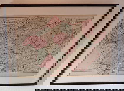
Sold2022Hamilton Farm James Cox Brady ResidenceHunterdon Somerset & Morris Counties Map is approx 33 1/2" x 43 1/2"See Sold Price
Sold2016County Map of the State of Texas 1884Map Title: County Map of the State of Texas Date: 1884 Publisher: WM. M. Bradley & Bro: Philadelphia Size: 14.25 x 21.25 inches Showing also portions of the adjoining states and territories." IncludesSee Sold Price
Sold2024Inyo and Mono County Stock and Cover [166239]1880 Homer Mill & Mining stock. Inyo Development cover to H Yerington per W F and Co's Express, 1892 cover. Inyo and Mono County CaliforniaSee Sold Price
Sold2023Logan County Mining & Mfg. Company of Virginia 1860 Bond 1860 [128796]Rare $500 bond 6%, 1860, 15 coupons. Coal train vignette. Signed by president J George Bolen and B M Weymouth as secretary. The lands of this company encompass 101,000 acres near Logan Courthouse on tSee Sold Price
Sold2022Colorado Mining Claim Maps (5) [152844]Lot of five miscellaneous Colorado mining claim maps. A) Map of Red Mountain and the Mining Region of San Juan, Ouray, San Miguel, and Dolores Counties, Colo. by Emil B. Fischer. 1891. Printed by RandSee Sold Price
Sold20171855 Barnes's Map of Pennsylvania. A new county m1855 Barnes's Map of Pennsylvania. A new county map of Pennsylvania and adjoining states. Showing Central and other railroads.-- Dimensions: H: 26 inches: W: 37.5 inches ---See Sold Price
Sold2021Scarce h/c map of Idaho, Cram 1882Early and scarce county map of Southern Idaho Territory showing limited railroads only in eastern portion of the state. One of them leads to and ends at Hailey, site of early silver mining (the map inSee Sold Price
Sold20221902 Map of Hunterdon County NJ Irving C HicksIrving Hicks Publisher, Pugh & Downing Engineers. Approx 42" x 50 1/2"See Sold Price
Sold2023Hearne Brothers Somerset County NJ MapPolyconic Projection map. Approx 50" x 65"See Sold Price
Sold20191886 County & Township map of Arizona & N. Mexico byA fine example of William M. Bradley's 1886 map of Arizona and New Mexico. Shows just ten counties in Arizona Territory and thirteen in New Mexico Territory (plus Indian Reservation in upper left of sSee Sold Price
Sold2023Official Map of Beaverhead County 1901Official Map of Beaverhead County, Montana, compiled from the latest official records by George R. Metlen, county surveyor, civil and mining engineer, Dillon, Montana, 1901. Measures approximately 44See Sold Price
Sold20181955 John Gaston Morris County Bridle Path MapApprox. 29" x 37" . It is loose in the frame and needs to be secured.See Sold Price
Sold2022Rough and Ready MC Stock from early Amador Mining District with Nevada County, California ties [1443# 175 for 12 1/2 shares to George Keys. Signed by B. B. Troxal and president S. M. Gilham. Dateline 1865 Austin N. T. Incorporated February 9, 1864. 25c Bond revenue stamp. Not cancelled. Vignette advSee Sold Price
Jun 07Freeman's | Hindman[HARDY, Thomas] -- HUTCHINS, John. The History and Antiquities of the County of Dorset by John$250
Jun 14DuMouchellesWilliam H. Gamble (American, B. 1863) Hand Colored Engraving, Ca. 1863, "County Map of Michigan And$50(1 bid)
1 day LeftKCM GalleriesLarge Detailed Original Oil Painting United States Map Julius Lira Salazar 48 x 36 inches$1,800
Jun 08Early American History Auctions1753 Map of the County of Lancaster Divided into its Hundreds, by Royal Mapmaker Emanuel Bowen$280
5 days LeftForum AuctionsAmerica.- California gold mining.- Palmer (N.S.) Autograph Letter signed to his brother on mining£400
Jun 08Early American History Auctions1720 Colonial Northumberland County Virginia Manuscript Deed and Map Plot$400
94 Lots AwayCain Modern AuctionsDouble Sided U.S. Map by Rand McNally, Illustrated & Equal Area Projection$75
6 days LeftFreeman's | Hindman[CIVIL WAR]. Small archive associated with Lt. Col. William M. Vogelson (1831-1892), 27th Ohio$250
Jun 07Freeman's | Hindman[MAP]. SARTINE, Antoine Plan de la Barre et du Havre de Charles-Town...1778. RARE REVOLUTIONARY WAR$1,000(1 bid)
Jun 08Simpson Galleries, LLC.JULIUS BIEN (1826-1909) AN AMERICAN CIVIL WAR RECONNAISSANCE MAP, "Map of Texas and Part of New$100
Jun 12Dan Morphy AuctionsMAP OF THE CHOCTAW NATION, INDIAN TERRITORY - COAL AND ASPHALT SEGREGATION 1903$150
Jun 23Treasure Quest AuctionsGreene County, NY Directory for 1896 by Fred Craigie, Catskill NY with Map$50
5 days LeftNY Elizabeth M. HANSIZ'S 1729 GERMANIA SACRA BLINDSTAMPED PIGSKIN ANTIQUE FOLIO WITH MAP$50


![Red Mining District Original Map; 1891 [152840]: Real, original Map of the Red Mountain Mining District, Ouray County, Colorado. Scale of 1000 ft. to 1 inch. W.A. Sherman M.E. Ouray, Colo. 1891. Printed by Rand McNally & Co. Engravers, Chicago. Has](https://p1.liveauctioneers.com/2699/258191/134290995_1_x.jpg?height=310&quality=70&version=1660351799)
![KEELER, J[ulius] M. Mining Map of Inyo County First Image](https://p1.liveauctioneers.com/514/20078/6859769_1_x.jpg?height=300&quality=1&width=300)
![KEELER, J[ulius] M. Mining Map of Inyo County First Image](https://p1.liveauctioneers.com/514/20078/6859769_1_x.jpg?height=300&quality=95&width=300)

![Newtown Mining Ledger, 1891 Etc. [174262]: 1891 Newtown Mining in Inyo county ledger page. 1889 Bullion and Exchange Bank check, small livestock letter in fair condition. Inyo California](https://p1.liveauctioneers.com/2699/316392/169726856_1_x.jpg?height=310&quality=70&version=1705535007)


![Inyo County (Cerro Gordo) Recorder Index [170571]: These pre-1885 Inyo County records of local mining claims exist only because of the recorder's family. The originals were lost in an 1885 fire. These are the only existing records up to 1874. The fact](https://p1.liveauctioneers.com/2699/299063/159201869_1_x.jpg?height=310&quality=70&version=1692045182)
![[MINING - CALIFORNIA]. The Skidoo News. Vol. I, No. 40.: [MINING - CALIFORNIA]. The Skidoo News. Vol. I, No. 40. Skidoo, Inyo County, CA: Skidoo Pub. Co., 20 September 1907.  4pp., folio, 15 1/2 x 22 in. Disbound (toned, split at central crease, chippi](https://p1.liveauctioneers.com/197/214395/109692117_1_x.jpg?height=310&quality=70&version=1628790729)


![Inyo and Mono County Stock and Cover [166239]: 1880 Homer Mill & Mining stock. Inyo Development cover to H Yerington per W F and Co's Express, 1892 cover. Inyo and Mono County California](https://p1.liveauctioneers.com/2699/324084/174415136_1_x.jpg?height=310&quality=70&version=1711485923)
![Logan County Mining & Mfg. Company of Virginia 1860 Bond 1860 [128796]: Rare $500 bond 6%, 1860, 15 coupons. Coal train vignette. Signed by president J George Bolen and B M Weymouth as secretary. The lands of this company encompass 101,000 acres near Logan Courthouse on t](https://p1.liveauctioneers.com/2699/311021/166411040_1_x.jpg?height=310&quality=70&version=1701193866)
![Colorado Mining Claim Maps (5) [152844]: Lot of five miscellaneous Colorado mining claim maps. A) Map of Red Mountain and the Mining Region of San Juan, Ouray, San Miguel, and Dolores Counties, Colo. by Emil B. Fischer. 1891. Printed by Rand](https://p1.liveauctioneers.com/2699/258191/134291009_1_x.jpg?height=310&quality=70&version=1660351799)


![[HARDY, Thomas] -- HUTCHINS, John. The History and Antiquities of the County of Dorset by John (1 of 2)](https://p1.liveauctioneers.com/197/329395/177650388_1_x.jpg?height=282&quality=70&version=1715364962)


![[CIVIL WAR]. Small archive associated with Lt. Col. William M. Vogelson (1831-1892), 27th Ohio (1 of 10)](https://p1.liveauctioneers.com/197/329785/177758363_1_x.jpg?height=282&quality=70&version=1715625218)
![[MAP]. SARTINE, Antoine Plan de la Barre et du Havre de Charles-Town...1778. RARE REVOLUTIONARY WAR (1 of 1)](https://p1.liveauctioneers.com/197/329395/177650540_1_x.jpg?height=282&quality=70&version=1715364962)


