Sold2020Pierre Duval Nova Mexico Map ca. 1660 CaliforniaPierre Duval (1618-1683), "Nova Mexico," Nuremberg, ca. 1660-1680. This rare map depicts California as an island, based on Sanson's depiction, along with the surrounding areas of Mexico and what is noSee Sold Price
Sold2020Mercator-Hondius Mexico Map ca. 1638Hendrik Hondius (1588-1651), Jan Jansson (1588-1664), and Gerardus Mercator (1512–1594), "Nova Hispania et Nova Galicia," Amsterdam: Hondius & Jansson, ca. 1638. Hand colored map of Mexico fromSee Sold Price
Sold2020United States Antique Map Ca 1826United States Map. Size: 11 X 8.5 inches approx. Unframed. Printed Circa 1826.See Sold Price
Sold2020West Indies Antique Map Ca 1826West Indies Map. Size: 11 X 8.5 inches approx. Unframed. Printed Circa 1826.See Sold Price
Sold2021Late 16th C. North Italian Steel Field Armor SuitWestern/Southern Europe, northern Italy, perhaps Brescia or Milan, and Germany, ca. 1580s CE. A suit of steel-plate armor used for field duties. The close helmet features a roped vertical crest, a visSee Sold Price
Sold2017An extremely attractive map of France and Belgium fromTabula tertia de Europa. Francesco Berlinghieri (1440-1501) attributed to Francesco Roselli (1445-before 1513). from Geographia. Engraved map. Florence: N. Laurentii, Alamanus, before 1482-early sixteSee Sold Price
Sold2022Dudley Sea Chart of DenmarkDUDLEY, Sir Robert (1574-1649). [Denmark] Carta particolare che comincia con il gran fiume Albis e contene parte dell mare Baltico e Ientrata al sondo di Danemarca... Engraved map. Florence, 1646.20 7See Sold Price
Sold2022Dudley Sea Chart of ArgentinaDUDLEY, Sir Robert (1574-1649). [Argentina] Carta particolare della costa di America Australe che comincia al C. di Matas sin al C. di Galegos. Engraved map. Florence, 1646. 20 7/8" x 16 1/8" sheet. SSee Sold Price
Sold2022Dudley Sea Chart of PortugalDUDLEY, Sir Robert (1574-1649). [Portugal] Carta Particolare Del Oceano Che Comincia Con il Capo S. Vincentio E Finisco Con Il Capo Roxo in PortogalloEngraved map. Florence, 1646. 20 7/8" x 17" sheet.See Sold Price
Sold2022Dudley Sea Chart of Western FranceDUDLEY, Sir Robert (1574-1649). [France] Carta particolare della costa di Guasconnia in Francia che comincia con il Fiuime di Burdeaux e Finisce con l'Isola di Heys. Engraved map. Florence, 1646. 20 7See Sold Price
Sold2023Mary Lane McMillan, "River Arno, Florence", 1910-12Mary Lane McMillan (Texas, 1883-1976), "River Arno, Florence", ca. 1910-1912, oil painting on canvas board sight: 11 1/2 x 15 1/2 in., frame: 21 x 24 1/2 in. Provenance: A King William mansion, San ASee Sold Price
Sold2022Rare 1818 Map Showing the Battle of Bunker Hill Sketched by Witness Henry de BerniereRare 1818 Map Showing the Battle of Bunker Hill Sketched by Witness Henry de Berniere Engraved map, Ca. 1818, Charlestown, MA. Entitled "Sketch of the Action on the Heights of Charlestown 17 June 1775See Sold Price
Sold20202 Maps of Spain2 Maps of Spain. 1). Ortelius (Abraham)-c ''Valentiae Regnieastern Spain''- showing Valencia, large ornamental cartouche and galleons in full sail, engraved map, ca. 1585. 13 3/4 x 19 1/2'' 2). BleauSee Sold Price
Sold2024Monumental Italian Giltwood Frame 40" x 54"Italian, possibly Florence, ca. 1840, carved and gilded in the Baroque taste. Overall 54 3/4" x 67 3/4", rabbet 40" x 54", molding 8".See Sold Price
Sold2018Original Harper's Southern States Civil War Map, C 1863Antique original Harper's Southern States Civil War Map, Ca.1863. On Top reads, “Map Of The Southern States, including rail roads, country towns, state capital, country roads, the southern coast froSee Sold Price
Sold2023Denver and Rio Grande Western Railroad MapStandard Gage & Narrow Gage Original map ca. 1870See Sold Price
Sold2017New York State MapNew York State Map ca. 1940 paper/linen/wood/metal 48.13" W x 1.75" D x 64.75" H Vintage New York social studies map manufactured by Denoyer-Geppert Co. of Chicago, IL, with working pull-down mechanisSee Sold Price
Sold2023A Harper's Pictorial History of War with Spain 1899 (First Edition)A Harper's Pictorial History of War with Spain 1899 (First Edition), together with Gray's Geological survey map ca~1882 and French map of Japan [3 total]See Sold Price
Sold2018Original Harper's Southern States Civil War Map, C 1863Antique original Harper's Southern States Civil War Map, Ca.1863. On Top reads, “Map Of The Southern States, including rail roads, country towns, state capital, country roads, the southern coast froSee Sold Price
Sold2018SDUK: Antique Map of Florence, Italy, 1835Title/Content of Map: Florence Cartographer: Baldwin & Cradock / SDUK Place & Date: London / 1835 Size: 14 7/8" x 11 1/8" Condition: river, forts, walls and gardens colored; light overall age toningSee Sold Price
Sold2018Cartographer's Original Manuscript MapCartographer's Original Manuscript Map Lake Pochartrain. (Found in a bound volume of Epsy's Weather Maps ca. 1840.)x Measures 10 7/8" x 8.5". Left corner torn away. Unframed, loose and not glued or moSee Sold Price
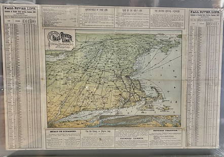
Sold2023Fall River Line, Old Colonial Railroad & Steamship Companies and CommunitiesOriginal Map. ca. 1887See Sold Price
Sold2017Cram: Antique Map of Nevada[Nevada]. Chicago: Geo. F. Cram, n.d. Coloured map. ca.1800. Approximately 20-3/4 x 13-3/4 inches image area, printed in black on cream paper, with hand colouring. Matted and shrink wrapped. Fine. TheSee Sold Price
Jun 14DuMouchellesWilliam H. Gamble (American, B. 1863) Hand Colored Engraving, Ca. 1863, "County Map of Michigan And$50(1 bid)
Jun 07Freeman's | HindmanHOMANN, Johann Baptist. Amplissimae Regionis Mississipi Seu Provinciae Ludovicianae. Nuremburg, [ca$400(1 bid)
6 days LeftHargesheimer Kunstauktionen DuesseldorfFLORENCE KNOLL QUADRATISCHER COUCHTISCH MODELL '2510'€100
Jun 14DuMouchellesAfter Carlo Dolci (Italian, 1616-1686) Oil on Canvas, Ca. 19th C., "Martyrdom of St. Andrew", H 49"$3,000
Jun 29JM Hobby Supply and Railroad Artifact AuctionsFlorence & Cripple Creek RR Public Timetable-September 1894$400
Jun 14DuMouchellesRigobert Bonne (French, 1727-1794) Hand Colored Engraving Ca. 18th Century, Les Etats Unis De$50
Jun 07Freeman's | Hindman[HARDY, Thomas]. -- WINDLE, C.A. The Wessex of Thomas Hardy. Edmund H. New, illustrator. 1902.$200
Jun 07Freeman's | HindmanWOOLWARD, Florence. The Genus Masdevallia... 1890-1896. FIRST EDITION.$1,200
Featured3 days LeftJasper52c1720 World showing Dutch East India Co possessions. CA as a island. By J.Malherbe$600
Jun 07Freeman's | Hindman[MORMONS]. MILLROY & HAYES (fl. 1899). Route of the Mormon Pioneers from Nauvoo to Great Salt Lake,$300
Jun 08Leon GalleryRobert Dudley (1573 - 1649) - Carta particolare del'Isola Mindano parte Australe con Celebes e₱500,000
4 days LeftPandora AuctionsVery Rare Vintage 1990s TOM FORD for GUCCI Sterling Silver Handcuffs$4,500
Jun 06Weatherham Estate TreasuresAfter Benvenuto Cellini "Statue of Perseus with the Head of Medusa" Sculpture - (7.9lbs)$420
Jun 14DuMouchellesWilliam Barker (American, 1770-1805) And Various Engravers Hand Colored Engraved Maps Ca. 18th/19th$50
6 days LeftTrillium Antique Prints & Rare BooksCollot's A Journey in North America - Atlas Volume with 36 Maps$200(1 bid)
11 hrs LeftArarity AuctionsAntique 19thC American Mahogany Chifforobe Style Cabinet Chest w/Doors and Drawers$100
3 days LeftJasper52Adam and Eve after Their Expulsion from Paradise by Amand-Durand after Lucas van Leyden, 1883$190
4 days LeftForum AuctionsItaly.- Zuccagni-Orlandini (Attillio) Atlante Geografico degli stati Italiani...[&] Atlante£1,500


![[Map of Florence] Duchetti, ca. 1580s First Image](https://p1.liveauctioneers.com/3532/117365/60345165_1_x.jpg?height=300&quality=1&version=1519867546&width=300)
![[Map of Florence] Duchetti, ca. 1580s First Image](https://p1.liveauctioneers.com/3532/117365/60345165_1_x.jpg?height=300&quality=95&version=1519867546&width=300)


![Dudley Sea Chart of Denmark: DUDLEY, Sir Robert (1574-1649). [Denmark] Carta particolare che comincia con il gran fiume Albis e contene parte dell mare Baltico e Ientrata al sondo di Danemarca... Engraved map. Florence, 1646.20 7](https://p1.liveauctioneers.com/1968/250616/130196505_1_x.jpg?height=310&quality=70&version=1654190895)
![Dudley Sea Chart of Argentina: DUDLEY, Sir Robert (1574-1649). [Argentina] Carta particolare della costa di America Australe che comincia al C. di Matas sin al C. di Galegos. Engraved map. Florence, 1646. 20 7/8" x 16 1/8" sheet. S](https://p1.liveauctioneers.com/1968/250616/130196501_1_x.jpg?height=310&quality=70&version=1654190895)
![Dudley Sea Chart of Portugal: DUDLEY, Sir Robert (1574-1649). [Portugal] Carta Particolare Del Oceano Che Comincia Con il Capo S. Vincentio E Finisco Con Il Capo Roxo in PortogalloEngraved map. Florence, 1646. 20 7/8" x 17" sheet.](https://p1.liveauctioneers.com/1968/250616/130196507_1_x.jpg?height=310&quality=70&version=1654190895)
![Dudley Sea Chart of Western France: DUDLEY, Sir Robert (1574-1649). [France] Carta particolare della costa di Guasconnia in Francia che comincia con il Fiuime di Burdeaux e Finisce con l'Isola di Heys. Engraved map. Florence, 1646. 20 7](https://p1.liveauctioneers.com/1968/250616/130196506_1_x.jpg?height=310&quality=70&version=1654190895)


![A Harper's Pictorial History of War with Spain 1899 (First Edition): A Harper's Pictorial History of War with Spain 1899 (First Edition), together with Gray's Geological survey map ca~1882 and French map of Japan [3 total]](https://p1.liveauctioneers.com/306/312718/167378281_1_x.jpg?height=310&quality=70&version=1702137534)


![Cram: Antique Map of Nevada: [Nevada]. Chicago: Geo. F. Cram, n.d. Coloured map. ca.1800. Approximately 20-3/4 x 13-3/4 inches image area, printed in black on cream paper, with hand colouring. Matted and shrink wrapped. Fine. The](https://p1.liveauctioneers.com/5584/107399/55057768_1_x.jpg?height=310&quality=70&version=1501794677)

![[MAP]. SPEED, John. A New Mappe of the Romane Empire. 1676. (1 of 2)](https://p1.liveauctioneers.com/197/329395/177650541_1_x.jpg?height=282&quality=70&version=1715364962)


![[HARDY, Thomas]. -- WINDLE, C.A. The Wessex of Thomas Hardy. Edmund H. New, illustrator. 1902. (1 of 3)](https://p1.liveauctioneers.com/197/329395/177650387_1_x.jpg?height=282&quality=70&version=1715364962)


![[MORMONS]. MILLROY & HAYES (fl. 1899). Route of the Mormon Pioneers from Nauvoo to Great Salt Lake, (1 of 2)](https://p1.liveauctioneers.com/197/329395/177650560_1_x.jpg?height=282&quality=70&version=1715364962)


![Italy.- Zuccagni-Orlandini (Attillio) Atlante Geografico degli stati Italiani...[&] Atlante (1 of 4)](https://p1.liveauctioneers.com/5458/329231/177514980_1_x.jpg?height=282&quality=70&version=1715269091)