Sold2019Antique Map: Germany (Deutschland)Description: Antique Map: Germany (Deutschland), Holstein, Hanover, Mecklenburg, the Prussian States, Saxony. Antique steel engraved map with original outline hand coloring. Date of printing: 1844. CaSee Sold Price
Sold2019"Germany, north of the Mayne" (Main). Prussia HanoverTITLE/CONTENT OF MAP: 'Germany, north of the Mayne' DATE PRINTED: 1817 IMAGE SIZE: Approx 53.5 x 65.0cm, 21 x 25.75 inches (Large); Please note that this is a folding map. TYPE: Antique early 19th cenSee Sold Price
Sold2023MAP, Germany, Braun & HogenbergMainz & Wurzburg, Germany & Sion, Switzerland. Braun & Hogenberg, Moguntia, Germaniae Metropolis, ad Rheni... [on sheet with] Herbipolis, Comuniter Wirtzburg... [and] Sedunum, Primaria & MetropoliticaSee Sold Price
Sold2023MAP, Germany, MunsterSouthern Germany. Sebastian Munster, Das Algow, from Cosmographey oder Beschreibung Aller Laender, 1578 (published). Hand Color. This charming woodblock map of southwestern Bavaria oriented with northSee Sold Price
Sold2022MAP, Germany, JanssonSoutheastern Germany. Jan Jansson, Franconiae Nova Descriptio, from Atlas Novus..., 1646 (circa). Hand Color. This elegantly engraved map focuses on the Franconia region of Germany, located in BavariaSee Sold Price
Sold20221982 The Rolling Stones Hanover Germany FlyerThis double sided flyer advertised a string of Rolling Stones shows in various cities in West Germany during a 1982 Europe Tour. Peter Maffay and the J. Geils Band played in support. Details regardingSee Sold Price
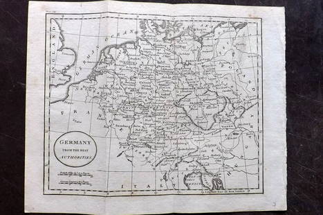
Sold2018FRAMED MAP, GERMANY NORTH OF THE MAYNEFramed map, "Germany, North of the Mayne", drawn and engraved for Thomson's New General Atlas, 1816, London engraved, hand colored highlights, sight approx: 20"h, 24.5"w, overall: 30"h, 34.5"w, 10.5lbSee Sold Price
Sold20222003 Rolling Stones Hanover Germany PosterHere we have an original poster promoting The Rolling Stones in Germany! The concert advertised here took place at the Open Air Arena in Hanover on August 8th, 2003, and was a stop on the Licks WorldSee Sold Price
Sold202118th C Large Handcolored Mercator Map GermanyLarge beautifully handcolored map of Braunswyck and Meydburg after Gerard Mercator circa 1640, this being an 18th century restike.. Printed at Amsterdam. Measures 23 x 19". Fine, reinforced central veSee Sold Price
Sold2022Barclay, James C1800 Hand Col Map. GermanyHand Colored Copper Engraved Map Published C1800 Halifax & Newcastle, England for "Barclay's Universal English Dictionary…" by James Barclay. Maps Engraved by Clerk, Milton and others. Paper Size: 1See Sold Price
Sold2019Barclay, James 1809 Hand Col Map. Germany & BohemiaHand Coloured Copper Engraved Map Published 1809, Leeds for "Barclay's Complete and Universal Dictionary of the English Language..." by the Rev. James Barclay. Folds as issued. Paper Size: 11 x 10 incSee Sold Price
Sold20211843-S Hanover, Germany Silver 1/12 Thaler.1843-S Hanover, Germany Silver 1/12 Thaler.See Sold Price
Sold2021Wilkes, John 1805 Hand Col Map. GermanyFinely Hand Colored Copper Engraved Map Published 1796-1828 London for "Encyclopaedia Londinensis, or universal dictionary of arts, sciences and literature" by John Wilkes et al. Paper Size: 10.5 x 8.See Sold Price
Sold2022Barclay, James 1812 Hand Col Map. GermanyHand Colored Copper Engraved Map Published 1812-13 by Brightly & Childs, Bungay for "A Complete and Universal Dictionary of the English Language..." by the Rev. James Barclay. Paper Size: 10.5 x 8 incSee Sold Price
Sold2022Times Atlas 1895 Lot of 7 Maps. GermanyLithograph Map Published 1895, London for "The Times Atlas" Two with Centre fold as published. Paper Size: Up to 21 x 16 inch (53 x 41cm) A couple with centre fold splits. A few other minor faults inSee Sold Price
Sold2021Tallis, John (Pub) 1852 Map. GermanySteel Engraved Map with Original Outline Hand Color Published 1852-56 by John Tallis, London for "The Universal Pronouncing Dictionary" by Thomas Wright. Drawn & Engraved by John Rapkin. Centre fold aSee Sold Price
Sold2021Tallis, John (Pub) 1852 Map. GermanySteel Engraved Map with Original Outline Hand Color Published 1852-56 by John Tallis, London for "The Universal Pronouncing Dictionary" by Thomas Wright. Drawn & Engraved by John Rapkin. Centre fold aSee Sold Price
Sold2021Thomson, John (Pub) 1825 Map. GermanyCopper Engraved Map Published 1825 by John Thomson, Edinburgh for "The Edinburgh School Atlas" by N. R. Hewitt. Maps Engraved by Hewitt. Engraved Vignette in corner. Original Outline Hand Colour. RareSee Sold Price
Sold2023Thomson, John (Pub) 1825 Map. GermanyCopper Engraved Map Published 1825 by John Thomson, Edinburgh for "The Edinburgh School Atlas" by N. R. Hewitt. Maps Engraved by Hewitt. Original Outline Hand Colour. Rare. Paper Size: 10.5 x 8 inch (See Sold Price
Sold2021Guthrie, William 1806 Map. GermanyCopper Engraved Map Published 1806, London for "A New Geographical, Historical and Commercial Grammar..." by William Guthrie. The maps are by John Senex, Thomas Kitchin and others. Folds as issued. PaSee Sold Price
Sold2021Guthrie, William 1798 Map. GermanyCopper Engraved Map Published 1798, London for "A New Geographical, Historical and Commercial Grammar..." by William Guthrie. The maps are by John Senex, Thomas Kitchin and others. Folds as issued. PaSee Sold Price
Sold2019Philip, George 1856 LG Hand Col Map. Germany North PartLarge Folio Lithograph Map Published Published 1856 by George Philip, Liverpool for "Philips' Commercial Atlas of the World" Paper Size: 26 x 21 inch (66 x 53cm) Light horizontal bend in centre. NeatlSee Sold Price
Sold2021Guthrie, William 1798 Map. GermanyCopper Engraved Map Published 1798, London for "A New Geographical, Historical and Commercial Grammar..." by William Guthrie. The maps are by John Senex, Thomas Kitchin and others. Folds as issued. PaSee Sold Price
Sold2019Philip, George 1856 LG Hand Col Map. Germany South PartLarge Folio Lithograph Map Published Published 1856 by George Philip, Liverpool for "Philips' Commercial Atlas of the World" Paper Size: 26 x 21 inch (66 x 53cm) Light horizontal bend in centre. NeatlSee Sold Price
Featured1 day LeftJasper521582 Braun and Hogenberg View of Halberstadt and Quedlinburg in Saxony -- Halberstadium, Urbs$220
5 days LeftRipley AuctionsWilliam A. Eyden, Germany / Indiana (1859-1919), woodland scene along a stream, gouache on paper, 21$100
1 day LeftJasper521552 Munster Map of Southern Germany and Switzerland -- Suevia et Bavaria XII Nova Tabula$160
1 day LeftJasper521593 de Jode Maps of Eastern Germany (Saxony Area) and Western Germany -- Mansfeldiae Comitatus ...$700
1 day LeftJasper521720 antique MAP of LOWER SAXONY GERMANY 18th CENT. Circulus Saxoniae inferioris$75
Jun 15Riverfront AuctionsC. 1730 Map of North Rhine-Westphalia, Germany after N. Sanson by Covens and Mortier$5
Featured1 day LeftJasper521759 HISTORY OF THE WORLD in GERMAN antique ILLUSTRATED w/ MAP of ARABIA vellum$200
1 day LeftJasper521552 Munster Map of Netherlands and Western Germany -- Brabantia III Rheniet X Nova Tabula$240
Jun 04Mark Louis Weseloh Estate LiquidationsSix - 17th c. Maps of Europe, Asia, England, Germany x2, Crete, Greece.8 1/4" x 6 5/8".$300
Featured1 day LeftJasper521705 de Fer Map of Basel -- Basle Ville Capitale du Canton du meme nom Situee sur le Rhein…$170


![MAP, Germany, Braun & Hogenberg: Mainz & Wurzburg, Germany & Sion, Switzerland. Braun & Hogenberg, Moguntia, Germaniae Metropolis, ad Rheni... [on sheet with] Herbipolis, Comuniter Wirtzburg... [and] Sedunum, Primaria & Metropolitica](https://p1.liveauctioneers.com/6576/279721/147265449_1_x.jpg?height=310&quality=70&version=1677104593)