Sold2017von Reilly: Map of North America, 1795Map: Karte von Amerika Nach d'Anville und Pownall/Karte von der Republik der Vereinigten Dreyzehen Staaten in Nord Amerika Cartographer: von Reilly Place & Date: Vienna / 1795 Size: 30" x 23" A highlySee Sold Price
Sold2017von Reilly: Map of Iceland, 1789Map: Die Insel Island Cartographer: von Reilly Place & Date: Vienna / 1789 Size: 11 1/4" x 9 1/4" A beautifully engraved and detailed map of Iceland based on the unpublished Knoff survey, with multiplSee Sold Price
Sold2021Guthrie, William 1790 Map. Turkey in Europe & HungaryCopper Engraved Map Published 1790, London for "A New Geographical, Historical and Commercial Grammar..." by William Guthrie. The maps are by John Senex, Thomas Kitchin and others. Folds as issued. EaSee Sold Price
Sold2023Côte NO de l'Amérique & côte NE de l’Asie. Alaska & Kamchatka. BONNE 1790 mapTITLE/CONTENT OF MAP: [Cook 3e Voyage] Carte de la côte Nord-Ouest de l'Amérique et de la côte Nord-Est de l’Asie // Plan de l'Entrée de Nootka [Cook's 3rd Voyage - Map of thSee Sold Price
Sold2023L’Isle de St Domingue et… Porto-Rico. Hispaniola & Puerto Rico. BONNE 1790 mapL’Isle de St Domingue et celle de Porto-Rico [The islands of Hispaniola and Puerto Rico] by Rigobert Bonne (1790). Antique 18th century copperplate map, 24.5 x 36.0cm, 9.5 x 14.25 inches; PleaseSee Sold Price
Sold2024Entrée de Norton & Détroit de Bhering. Bering Strait Norton Sound BONNE 1790 mapTITLE/CONTENT OF MAP: [Cook 3e Voyage] Carte de l'entrée de Norton et du Détroit de Bhering, où l'on voit le Cap le plus Oriental de l'Asie et la pointe la plus Occidentale de l'AméSee Sold Price
Sold2015EARLY MAPS OF SKOWHEGAN AND MADISON, MAINEEARLY MAPS OF SKOWHEGAN AND MADISON, MAINE Early hand-drawn and colored map of Skowhegan, Maine, 15 1/2" x 12 1/2", a copy of a 1790 map executed in Boston, Feb. 2, 1791and showing the Kennebec and SaSee Sold Price
Sold2021Guthrie, William 1790 Antique Map. IrelandCopper Engraved Map Published 1790, London for "A New Geographical, Historical and Commercial Grammar..." by William Guthrie. The maps are by John Senex, Thomas Kitchin and others. Folds as issued. EaSee Sold Price
Sold2021Guthrie, William 1790 Antique Map. Spain & PortugalCopper Engraved Map Published 1790, London for "A New Geographical, Historical and Commercial Grammar..." by William Guthrie. The maps are by John Senex, Thomas Kitchin and others. Folds as issued. EaSee Sold Price
Sold2021Guthrie, William 1790 Antique Map. ItalyCopper Engraved Map Published 1790, London for "A New Geographical, Historical and Commercial Grammar..." by William Guthrie. The maps are by John Senex, Thomas Kitchin and others. Folds as issued. EaSee Sold Price
Sold2021Guthrie, William 1790 Antique Map. Russia or MuscovyCopper Engraved Map Published 1790, London for "A New Geographical, Historical and Commercial Grammar..." by William Guthrie. The maps are by John Senex, Thomas Kitchin and others. Folds as issued. EaSee Sold Price
Sold2021Guthrie, William 1790 Antique Map. FranceCopper Engraved Map Published 1790, London for "A New Geographical, Historical and Commercial Grammar..." by William Guthrie. The maps are by John Senex, Thomas Kitchin and others. Folds as issued. EaSee Sold Price
Sold2021Guthrie, William 1790 Antique Map. ScotlandCopper Engraved Map Published 1790, London for "A New Geographical, Historical and Commercial Grammar..." by William Guthrie. The maps are by John Senex, Thomas Kitchin and others. Folds as issued. EaSee Sold Price
Sold2024A rare American Federal tiger maple document or map cabinet, circa 1790A rare American Federal document or map cabinet, circa 1790, executed in highly figured tiger maple, of table form fitted with two long drawers, rising on turned legs terminating on brass casters, 29"See Sold Price
Sold2018Kitchin: Antique Map of Africa, 1790Title/Content of Map: Africa from the Best Authorities. Date Printed: 1790 Cartographer: KITCHIN, T. Size (inches): 19x25.3 Illustration map from Guthrie's Geography. Rather detailed. Polar projectionSee Sold Price
Sold2020Map Asia Buffier 1790Very beautiful map of Asia Author: Buffier Claude (1671-1737) Atlas: Geografia Universale del Padre Claudio Buffier... (italian ediction) Date: 1790 Technique: etching on copper Leaf Dimension: 21x20See Sold Price
Sold2023Turquie d’Europe. Turkey in Europe. Greece & the Balkans. BONNE 1790 old mapTitle: Turquie d’Europe. Turkey in Europe. Greece & the Balkans. BONNE 1790 old map Description: Turquie d’Europe [Turkey in Europe] by Rigobert Bonne (1790). Antique 18th century copperplate map,See Sold Price
Sold2022Mitchell's Map of the states of Louisiana, Mississippi, & Alabama 1834MITCHELL, Samuel Augustus (1790-1868). Map of the states of Louisiana, Mississippi, & Alabama. Engraved map with original hand color. Philadelphia: S. Augustus Mitchell, 1834. 17 1/2" x 12 1/2" sheet.See Sold Price
Sold2024An English Needlepoint MapAn English Needlepoint Map Jane Beilby, 1790 showing the counties of England and Wales. 20 x 20 1/4 inches (sight).See Sold Price
Sold2017SAMUEL AUGUSTUS MITCHELL (AMERICAN,1790-1868) MAP OFSAMUEL AUGUSTUS MITCHELL (AMERICAN,1790-1868) MAP OF KENTUCKY AND TENNESSEE hand-colored lithograph on paper, "Map of Kentucky and Tennessee Compiled from the Latest Authorities", published 1831 in PhSee Sold Price
Sold2018Mitchell Map of Oregon, Washington & Part of Idaho 1860**Originally Listed At $100** Samuel Augustus Mitchell (American, 1790-1868), "Map of Oregon, Washington, and part of Idaho." 1860. A beautiful antique, hand-colored and engraved map that depicts OregSee Sold Price
Sold2019Two Maps by Samuel Augustus Mitchell (1790-1868), "MapTwo Maps by Samuel Augustus Mitchell (1790-1868), "Map of North America," No. 4, 1852, hand colored, H. -11 1/2 in., W. - 9 1/8 in. (2 Pcs.)See Sold Price
Sold2019Samuel Augustus Mitchell (1790-1868), "Map of the StateSamuel Augustus Mitchell (1790-1868), "Map of the State of Texas," 1852, No. 13, hand colored, H. -9 in., W. - 15 3/8 in.See Sold Price
2 days LeftJasper52Détroit de Magellan. Strait of Magellan. Chile. BONNE 1790 old antique map$30
Jun 23Schilb Antiquarian Rare Books1790 Life of Jesus Christ Fleetwood Bible ART Miracles Jerusalem MAP Holy Land$42(2 bids)
5 days LeftTrillium Antique Prints & Rare BooksDobson - Map of the World with Chart of Torrid Zone or Tropical Regions of the World$50
2 days LeftJasper52A lawyer in his study. Antique engraving print by W.H. Worthington after A. Ostade.$85
2 days LeftCedarburg Auction & Appraisals LLCSet of Four 17th Century Maps Showing All of Spain and Portugal$450(2 bids)
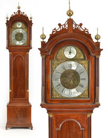
6 days LeftTremont AuctionsSamuel Mulliken mahogany tall case clock with composite brass dial, circa 1790. The Chippendale case$1,200


![Côte NO de l'Amérique & côte NE de l’Asie. Alaska & Kamchatka. BONNE 1790 map: TITLE/CONTENT OF MAP: [Cook 3e Voyage] Carte de la côte Nord-Ouest de l'Amérique et de la côte Nord-Est de l’Asie // Plan de l'Entrée de Nootka [Cook's 3rd Voyage - Map of th](https://p1.liveauctioneers.com/5584/310511/166159558_1_x.jpg?height=310&quality=70&version=1701205563)
![L’Isle de St Domingue et… Porto-Rico. Hispaniola & Puerto Rico. BONNE 1790 map: L’Isle de St Domingue et celle de Porto-Rico [The islands of Hispaniola and Puerto Rico] by Rigobert Bonne (1790). Antique 18th century copperplate map, 24.5 x 36.0cm, 9.5 x 14.25 inches; Please](https://p1.liveauctioneers.com/5584/305600/163297718_1_x.jpg?height=310&quality=70&version=1697577828)
![Entrée de Norton & Détroit de Bhering. Bering Strait Norton Sound BONNE 1790 map: TITLE/CONTENT OF MAP: [Cook 3e Voyage] Carte de l'entrée de Norton et du Détroit de Bhering, où l'on voit le Cap le plus Oriental de l'Asie et la pointe la plus Occidentale de l'Amé](https://p1.liveauctioneers.com/5584/326888/175994368_1_x.jpg?height=310&quality=70&version=1713903186)


![Turquie d’Europe. Turkey in Europe. Greece & the Balkans. BONNE 1790 old map: Title: Turquie d’Europe. Turkey in Europe. Greece & the Balkans. BONNE 1790 old map Description: Turquie d’Europe [Turkey in Europe] by Rigobert Bonne (1790). Antique 18th century copperplate map,](https://p1.liveauctioneers.com/5584/312166/167043301_1_x.jpg?height=310&quality=70&version=1702414502)