Sold2016Collection of Antiquated Maps of the Holy Land [8],Collection of eight geographic maps of the Holy Land. Various maps. Printed in various countries. Some maps with tribal divisions. Fine - very fine condition.See Sold Price
Sold2020Antique Johnson and Ward "Holy Land" MapDESCRIPTION: map of the Holy Land, based upon the 12 tribes and contemporary (to mid-19th Century) borders. Insets of view of Damascus and town plan of Jerusalem. Shows towns, roads, rivers, lakes, moSee Sold Price
Sold2016c. 1670 Engraved Holy Land + Mediterranean MapHistoric Maps c. 1670 Engraved Map of the Holy Land & Mediterranean Sea c. 1670, Historic Hand-Colored Engraved Map entitled: “Terra Sancta sive Promissionis olim Palestina recens delineata,” by FSee Sold Price
Sold2018Charles Wilhem - Binder of Maps of the Holy Land.Karte von Palastina von C.W.M. Van De Velde. Gotha, 1866. Eight color geographic maps depicting various areas of the Land of Israel by cartographer Charles Wilhem. Following a change in Ottoman EmpireSee Sold Price
Sold2022With maps, vignettes and 120 engraved platesHeading: Author: Carne, John Title: Syria, The Holy Land, Asia Minor, &c. Illustrated Place Published: London, Paris, & America Publisher:Fisher, Son & Co. Date Published: [c. 1838] DeSee Sold Price
Sold2017Palestine and the Holy Land with mapHeading: Author: Russell, Michael Title: Palestine, Or the Holy Land. From the Earliest Period to the Present Time. Place Published: New York Publisher:J. & J. Harper Date Published: 1832See Sold Price
Sold2023Calmet, Augustin 1732 Large Map. Old Jerusalem, Israel, Holy Land"A Description of Old Jerusalem according to Villalpandus" Folio Copper Plate Published 1732, London for "An Historical, Critical, Geographical, Chronological and Etymological Dictionary of the Holy BSee Sold Price
Sold2023Calmet, Augustin 1732 LG Map. Countries mentioned by the Apostles, Holy Land, Med, Europe Arabia"A Particular Description of the Countries mentioned by the Apostles..." Folio Copper Plate Published 1732, London for "An Historical, Critical, Geographical, Chronological and Etymological DictionarySee Sold Price
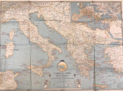
Sold2020Vintage National Geographic MagazineDescription: Vintage paper map from National Geographic Magazine, depicting the classical lands of the Mediterranean. Copyright 1940. Material: paper. Measurement: approximate 26.5"h x 34"w (INCHES).See Sold Price
Sold20241872 Holy BIBLE & Hitchcock Analysis Gruden Concordance Theology MAPS Holy Land1872 Holy BIBLE & Hitchcock Analysis Gruden Concordance Theology MAPS Holy Land A rare, 19th-century book of systematic theology published by the Johnson in New York. This edition of Hitchcocks CompleSee Sold Price
Sold2017Map, holy land, Palestine, by Abraham Ortelius, 1612Early map, Palestine, holy land, by Abraham Ortelius, published in Antwerp, 1612, 14.5" by 18.5"See Sold Price
Sold2022MAP, Holy Land, JanssonHoly Land. Jan Jansson, Tabula Itineraria Patriarcharum Abrahami, Isaaci et Iacobi, from Accuratissima Orbis Antiqui Delineatio…, 1657 (published). Hand Color. A fine decorative map illustrating theSee Sold Price
Sold2019MAP - Holy Land. Mercator/HondiusHoly Land. Mercator/Hondius, Peregrinatio Israelitaru in Deserto, 1610 (published). Hand Color. A handsome small map depicting the Exodus and the wandering of the Children of Israel. An inset of the ESee Sold Price
Sold20151812 Hand Colored Map Holy landHandcolored map of the “Tribe of Manasseh” in the Holy land , printed by Mathews and Leigh, 1812. Measures 11 x 9”.See Sold Price
Sold2024Marmocchi, F. C. 1845 Hand Col Map. Holy Land. Canaan. Israel PalestineFolio Hand Colored Etching/Engraving Published 1845, Florence for "Atlante di Geografia-Storica Universale" by Francesco C. Marmocchi. Paper Size: 17 x 11 inch (43 x 28cm) Good ConditionSee Sold Price
Sold2024Marmocchi, F. C. 1845 Hand Col Map. Holy Land. Persia Empire, Alexander the GreatFolio Hand Colored Etching/Engraving Published 1845, Florence for "Atlante di Geografia-Storica Universale" by Francesco C. Marmocchi. Paper Size: 17 x 11 inch (43 x 28cm) Good ConditionSee Sold Price
Sold2024Marmocchi, F. C. 1845 Hand Col Map. Holy Land. Israel, Jerusalem insetFolio Hand Colored Etching/Engraving Published 1845, Florence for "Atlante di Geografia-Storica Universale" by Francesco C. Marmocchi. Paper Size: 17 x 11 inch (43 x 28cm) Good ConditionSee Sold Price
Sold2019Holy land, Jordan and CyprusTitle/Content of Map: Holy land, Jordan and Cyprus Date: 1598/99 Cartographer: By Ruscelli Size: 11x9” Provenance: Venice Reserve: $225.00 Shipping: Domestic: Free shipping to anywhere within the coSee Sold Price
2018Seutter: Antique Map of Holy Land, 1740Title/Content of Map: Holy Land by Sutter Date Printed: c1740 Cartographer: Matthaus Seutter Material/Medium: Paper Size: 24" x 19 1/2" Original hand colored Copperplate engraved. Published in AugsburSee Sold Price
Sold20241849 Mitchell School ATLAS 24 MAPS America Holy Land France Africa Egypt Asia1849 Mitchell School ATLAS 24 MAPS America Holy Land France Africa Egypt Asia The name Mitchell has long been synonymous with 19th-century maps; in fact, Mitchell maps are often considered the best ofSee Sold Price
Sold20221687 Blome Engraved Maps Canaan Holy Land JerusalemTitle: 1687 Blome Engraved Maps Canaan Holy Land Jerusalem Description: Finely engraved "Canaan Commonly called the Holy Land of Promise …..", engraved by Richard Palmer for Richard Blome (1641-See Sold Price
Sold2020Bartholomew, John 1922 Lot of 5 Maps Egypt & Holy LandIncl Egypt and The Nile, Lower Egypt, Asia Minor/Syria/Mesopotamia, Palestine and Persia. Large Lithograph Maps Published 1922 by The Times, London for "The Times Survey Atlas of the World" Maps by JoSee Sold Price
Sold2022Cellarius & Patrick 1816 Map. Syria & Holy Land"Syria, Coelesyria, Phoenicia & Mesopotamia" Copper Engraved Map Published 1816, London for "Geographia Antiqua" by Samuel Patrick. Maps based on those by Andreas Cellarius. Folds as issued. Paper SizSee Sold Price
Sold2023Antique Map of Holy Land Palestine Map, Israel Twelve Tribes Jerusalem 1833 Lapie Large Folio MapAntique Holy Land Palestine Israel Twelve Tribes Jerusalem Antique 1833 Lapie Large Folio MapAntique Holy Land Palestine Israel Twelve Tribes Jerusalem 1833 Lapie Large Folio Map. Carte de la PalestinSee Sold Price
1 day LeftTrillium Antique Prints & Rare BooksDe Jode, Rare, pub. 1593 - Map of Europe (Nova Totius Europae Tabula)$160(4 bids)
Jun 02Schilb Antiquarian Rare Books1871 Holy BIBLE & MAPS Holy Land Hitchcock Analysis Gruden Concordance Theology$120(3 bids)
5 days LeftJ. Greenstein & Co., Inc.A GROUP OF HISTORIC PAMPHLETS AND ARTICLES ON THE ARAB REFUGEE CRISIS AFTER THE CREATION OF THE$275
1 day LeftTrillium Antique Prints & Rare BooksDavid Roberts - The Great Sphinx, Pyramids of Gizeh$200
1 day LeftTrillium Antique Prints & Rare BooksDavid Roberts - Front Elevation of the Great Temple of Aboosimble, Nubia$200
7 days LeftNY Elizabeth FIRST US EDITION OF 1869 MALAY ARCHIPELAGO BY A.WALLACE, ANTIQUE ILLUSTRATED WITH MAPS$50(1 bid)
Jun 23Schilb Antiquarian Rare Books1790 Life of Jesus Christ Fleetwood Bible ART Miracles Jerusalem MAP Holy Land$42(2 bids)
5 days LeftThe Bidder AuctionsJohann Baptista Homann. Terra Sancta Holy Land Map with the Borders of the 12 Tribes of Israel, Hand$100
Jun 08Early American History AuctionsLot of Miscellaneous Printed Articles and Reproduction Souvenier Continental Army USA Design Buttons$100


![Collection of Antiquated Maps of the Holy Land [8],: Collection of eight geographic maps of the Holy Land. Various maps. Printed in various countries. Some maps with tribal divisions. Fine - very fine condition.](https://p1.liveauctioneers.com/2398/83799/43284471_1_x.jpg?height=310&quality=70&version=1452094856)


![With maps, vignettes and 120 engraved plates: Heading: Author: Carne, John Title: Syria, The Holy Land, Asia Minor, &c. Illustrated Place Published: London, Paris, & America Publisher:Fisher, Son & Co. Date Published: [c. 1838] De](https://p1.liveauctioneers.com/642/255997/133163486_1_x.jpg?height=310&quality=70&version=1658864460)