Sold2021Glass World Globe PaperweightClear glass globe with textured and shaded world map continents. Measures 3 x 3.25 in. Desktop items, Paper & table accessories, home accents and decor, Art glass paperweight, globe paperweight, worldSee Sold Price
Sold2020Framed Antique Map Orbis Vetus, Robert De VaugondyItem/Description: Old print. Map of the world by Robert de Vaugondy from 1752. Orbis vetus in utraque continente : In both the old continent / world map / Vaugondy 1752. Material: Print framed under gSee Sold Price
Sold2022ORTELIUS, ABRAHAM; and PHILILLPE GALLE. Set of 5 miniature maps of the world and continents.ORTELIUS, ABRAHAM; and PHILILLPE GALLE. Set of 5 miniature maps of the world and continents. Engravings with original hand-color. 4x5½ inches each sheet size, Latin text on verso; light finger soSee Sold Price
Sold2022Curtis Jere, Pair of Earth Globe Mid Century WallCurtis Jere, pair of mid century modern wall art sculptures, globe form map of the world, featuring the continents with topography features. Approximately 19.9375W x 2.125H in.See Sold Price
Sold2023Assorted Maps on Europe & the Sub ContinentAssorted maps on Europe, Scandinavia, and the Sub Continent, including Celestial and World Maps, some old and hand colored, some modern and picture reproductions. Provenance: Phyllis Lucas Gallery, NYSee Sold Price
Sold2022Anthony Finley’s 1833 map of The WorldLovely example of Finley's attractive The World on Mercator's Projection, from his 1833 New General Atlas. The world’s continents are shown in clear detail, with many rivers, cities, coastal feaSee Sold Price
Sold2022World.- Bordone (Benedetto di) [World Map], woodcut, [1522].World.- Bordone (Benedetto di) [World Map], early map showing the recent developments in cartography and departing from Ptolemaic models, including open water between the two continents and not joininSee Sold Price
Sold2022Wells' world map with California an Island 1700Heading: Author: Wells, Edward Title: A New Map of the Terraqueous Globe according to the Ancient Discoveries and most general Divisions of it into Continents and Oceans Place Published: London PubliSee Sold Price
Sold2023World Map by Ceramiche Zaccacnini, set as Coffee TableLot 133 World Map by Ceramiche Zaccacnini, set as Coffee Table map of the world, centered on the Atlantic Ocean and surrounding continents 19 x 36 x 20 1/2 inches Provenance: Property from the CollecSee Sold Price
Sold2022Buffon & Tardieu 1853 Map. Ancient World"Carte de l'Ancien Continent" Steel Engraved Map with outline hand color Published 1853-55, Paris for "Oeuvres Completes de Buffon" by the Comte de Buffon. Engraved by Ambroise Tardieu. Paper Size: 10See Sold Price
Sold2022Buffon & Tardieu 1853 Map. New World"Carte de Nouveau Continent" Steel Engraved Map with outline hand color Published 1853-55, Paris for "Oeuvres Completes de Buffon" by the Comte de Buffon. Engraved by Ambroise Tardieu. Paper Size: 10See Sold Price
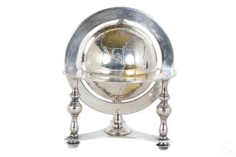
Sold2023Bulgari Sterling Silver & Vermeil Table Globe 805gA Bulgari Italian sterling silver table globe sculpture. Classical style design with spinning world map globe set within a round tri legged ring stand. Map continents finished in gold vermeil, and surSee Sold Price
Sold2016The World On Mercator's Projection, 1829Map: The World On Mercator's Projection Maker: Anthony Finley Date: 1829 Size: Quarto, 8.9 inches high x 11.10 inches wide Details the world centered on the Pacific Ocean. Shows continents, countries,See Sold Price
Sold2022Glass Lamp Globe, Imprinted Map of the WorldAmber glass lamp globe, with raised continents showing a map of the world. Handblown into a two piece mold. From Columbian Exposition 1893 Chicago World’s Fair; One likely hung in the electriciSee Sold Price
Sold2019Bartholomew, John 1922 Group of 3 Maps of AfricaIncl Africa Continent, North Africa and West Africa. Large Lithograph Maps Published 1922 by The Times, London for "The Times Survey Atlas of the World" Maps by John George Bartholomew of the EdinburgSee Sold Price
Sold2017Mallet: Antique Map of the World; France, 1683Map Title: 'Planisphere du Monde; France' FRANCE/WORLD. odd-shaped Australia close to southern continent. Date Printed: 1683 Image Size: Approx Overall page size 13 x 21cm approximately (5 x 8 inches)See Sold Price
Sold20211830 "A New Atlas World" Educational School Map Book1830 "A New Atlas World"Antique Educational School Maps. This is a wonderful antique atlas for early education, geography classes. It has a layout of the world and the breakdown of each continent. BecSee Sold Price
Sold2023Buffon & Vaugondy 1830 Map of the Old World"Carte de L'Ancien Continent" Lithograph Published 1828-33, Brussels for "Oeuvres completes de Buffon" by the Comte de Buffon and Louis-Jean-Marie Daubenton. Folds as issued. Paper Size: 12 x 10 inchSee Sold Price
Sold2022Ottoman, Turkish AtlasAn Ottoman, Turkish book dating back to the late Ottoman Empire (1927). It consists of 16 pages (20 by 24 cm) on which 18 maps are drawn. Maps that include the oceans and continents of the world.ThisSee Sold Price
Sold2017Mallet: Antique Map of the World/France, 1683Title/Content of Map: 'Planisphere du Monde; France' FRANCE/WORLD. odd-shaped Australia close to southern continent. Date Printed: 1683 Image Size: Approx Overall page size 13 x 21cm approximately (5See Sold Price
Sold2021Cram's Unrivaled Atlas of the World [131661]Maps of the continents, countries, colonies, plus all geographical and political divisions of the world. Also contains astronomical charts, diagrams, maps and descriptive matter. There are ancient claSee Sold Price
Sold20211627 Carte de l'Amerique Corrigee, et Augmentee, dessusBy: Bertius/TavernierDate: 1627 (circa)Dimensions: 20 x 15.25 inches (50.75 x 38.5 cm)According to Burden, "This rare map is one of a set of the four known continents that Melchior Tavernier had engraSee Sold Price
Sold2022MAP, South America, SeutterSouth America. Seutter/Lotter, America Meridionalis, per sua Regna Provinc: et Ins: Juxta Observation: et Descript Recentis: Divisa et Adornata Cura et Opera, from Atlas Minor, 1744 (circa). Hand ColoSee Sold Price
Sold2021Barlow 1807 Antique Map of Europe ContinentCopper Engraved Map Published 1807 by Brightly & Kinnersley, Bungay, England for "A General View of the World, Geographical, Historical and Philosophical" by The Rev. E. Blomfield. Maps Engraved by BaSee Sold Price
5 days LeftTrillium Antique Prints & Rare BooksSanson - Map of the Philippines and Ladrones Islands$75
3 days LeftForum AuctionsAgriculture & Botany.- Virgilius Maro (Publius) The Georgicks of Virgil, translated & edited by John£340
5 days LeftTrillium Antique Prints & Rare BooksSanson - Map of the Sunda Islands, Sumatra, Java, & Borneo$75
May 30The Rug LifeTHE SECOND WORLD WAR AND HISTORY OF ENGLISH-SPEAKING PEOPLE, BOTH BY SIR WINSTON CHURCHILL. 9$300
2 days LeftHannam's Auctioneers LtdThe Complete Atlas of Modern, Classical and Celestial Maps, together with Plans of the Principal Cit£240
2 days LeftThomaston Place Auction GalleriesCOLLECTION OF TRAVEL EPHEMERA, BROCHURES, BOOKLETS, MAPS 1900-1950$100
Jun 02Schilb Antiquarian Rare Books1897 History of British Empire England Scotland Canada James II MAPS India 6v$3(2 bids)
Jun 07Freeman's | HindmanCOOK, James, Captain. -- [SECOND VOYAGE]. A Voyage towards the South Pole, and Round the World...$1,500


![World.- Bordone (Benedetto di) [World Map], woodcut, [1522].: World.- Bordone (Benedetto di) [World Map], early map showing the recent developments in cartography and departing from Ptolemaic models, including open water between the two continents and not joinin](https://p1.liveauctioneers.com/5458/252576/131355887_1_x.jpg?height=310&quality=70&version=1655911671)


![Cram's Unrivaled Atlas of the World [131661]: Maps of the continents, countries, colonies, plus all geographical and political divisions of the world. Also contains astronomical charts, diagrams, maps and descriptive matter. There are ancient cla](https://p1.liveauctioneers.com/2699/202326/102449349_1_x.jpg?height=310&quality=70&version=1619652794)


![[MAP]. ORTELIUS, Abraham. Aevi Veteris, Typus Geographicus. 1601. (1 of 3)](https://p1.liveauctioneers.com/197/329395/177650532_1_x.jpg?height=282&quality=70&version=1715364962)


![COOK, James, Captain. -- [SECOND VOYAGE]. A Voyage towards the South Pole, and Round the World... (1 of 2)](https://p1.liveauctioneers.com/197/329395/177650491_1_x.jpg?height=282&quality=70&version=1715364962)