Sold2023Ptolemy, Fries, pub. 1535 - Map of TurkeyThis important historic map is from Geographicae enarrationis libri octo Ex Bilibaldi Pirckeymheri tralatione, fed ad Graeca & prisca exemplaria.... The work was published in 1535 in Lyon after LorenzSee Sold Price
Sold2023Ptolemy, Fries, pub. 1535 - Map of Northern Africa and EgyptThis important historic map is from Geographicae enarrationis libri octo Ex Bilibaldi Pirckeymheri tralatione, fed ad Graeca & prisca exemplaria.... The work was published in 1535 in Lyon after LorenzSee Sold Price
Sold2024Ptolemy & Magini, pub. 1620 - Map of India and Surrounding Islands (East Indies)This early map engraving is from Claudius Ptolemaeus (Ptolemy) and Giovanni Antonio Magini's Geografia cio? Descrittione Universale della Terra Partita in due volumni, Nel Primo de' quali si contengonSee Sold Price
Sold2021Stanford (Pub) 1894 Lot of 9 Maps of Asia East IndiesIncl Celebes, Sumatra, Borneo, Java, Philippines, Stations of Government Officials in the East Indies, Volcanic System of Malaysia, Moluccas, and Sunda Islands. Lithograph Maps Published 1894 by EdwarSee Sold Price
Sold2023World: Ptolemy, pub. 1562 - Map of the Ancient WorldThis early map engraving is Joseph Moleti (Giseppi Moleti [Moletius])'s edition of Claudius Ptolemaeus (Ptolemy)'s Geographia. This is the first Moleti Latin edition of the work and was published by VSee Sold Price
Sold2023Ptolemy, pub. 1562 - Map of ItalyThis early map engraving is Joseph Moleti (Giseppi Moleti [Moletius])'s edition of Claudius Ptolemaeus (Ptolemy)'s Geographia. This is the first Moleti Latin edition of the work and was published by VSee Sold Price
Sold2023Ptolemy, pub. 1562 - Map of Sardinia & SicilyThis early map engraving is Joseph Moleti (Giseppi Moleti [Moletius])'s edition of Claudius Ptolemaeus (Ptolemy)'s Geographia. This is the first Moleti Latin edition of the work and was published by VSee Sold Price
Sold2023Ptolemy, pub. 1562 - Map of Sardinia & SicilyThis early map engraving is Joseph Moleti (Giseppi Moleti [Moletius])'s edition of Claudius Ptolemaeus (Ptolemy)'s Geographia. This is the first Moleti Latin edition of the work and was published by VSee Sold Price
Sold2024Ptolemy & Magini, pub. 1620 - Map of the British Isles (England, Scotland, Ireland) / Verso: Map ofThis early map engraving is from Claudius Ptolemaeus (Ptolemy) and Giovanni Antonio Magini's Geografia cio? Descrittione Universale della Terra Partita in due volumni, Nel Primo de' quali si contengonSee Sold Price
Sold2024Ptolemy & Magini, pub. 1620 - Map of Sardinia & SicilyThis early map engraving is from Claudius Ptolemaeus (Ptolemy) and Giovanni Antonio Magini's Geografia cio? Descrittione Universale della Terra Partita in due volumni, Nel Primo de' quali si contengonSee Sold Price
Sold2021Tallis, John (Pub) 1852 Map Falkland Islands, PatagoniaSteel Engraved Map with Original Outline Hand Color Published 1852-56 by John Tallis, London for "The Universal Pronouncing Dictionary" by Thomas Wright. Drawn & Engraved by John Rapkin. Centre fold aSee Sold Price
Sold2021Tallis, John (Pub) 1852 Map. West India IslandsSteel Engraved Map with Original Outline Hand Color Published 1852-56 by John Tallis, London for "The Universal Pronouncing Dictionary" by Thomas Wright. Drawn & Engraved by John Rapkin. Centre fold aSee Sold Price
Sold2021Tallis, John (Pub) 1852 Map. Polynesia. Pacific IslandsSteel Engraved Map with Original Outline Hand Color Published 1852-56 by John Tallis, London for "The Universal Pronouncing Dictionary" by Thomas Wright. Drawn & Engraved by John Rapkin. Centre fold aSee Sold Price
Sold20211750 Bellin Engraved Map of SumatraA folding map of the island of Sumatra , "Carte de L'Isle De Sumatra…", by Jacque Bellin circa 1750, Paris. Close trimmed at top margin. Fine, measures 15.5 x 10". Reserve: $80.00 Shipping: DomesticSee Sold Price
Sold2024Ptolemy & Magini, pub. 1620 - Double Hemisphere Map of the WorldThis early map engraving is from Claudius Ptolemaeus (Ptolemy) and Giovanni Antonio Magini's Geografia cio? Descrittione Universale della Terra Partita in due volumni, Nel Primo de' quali si contengonSee Sold Price
Sold2022Ptolemy / Waldseemuller Map of Sri Lanka or Taprobana, 1513 or 1520PTOLEMY, Claudius (2nd Century) & WALDSEEMULLER, Martin (1470-1520). [Sri Lanka or Taprobana] Duodecima Asiae Tabula. Woodcut Map with original hand color. Strasbourg: Schott, 1513 or 1520. 17 1/2" xSee Sold Price
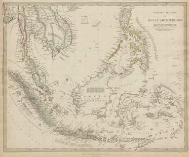
Sold2020MALAY ARCHIPELAGO Indonesia Malaysia PhilippinesTITLE/CONTENT OF MAP: 'EASTERN ISLANDS OR THE MALAY ARCHIPELAGO. Sumatra, Java, Borneo, etc' The top image on the right hand side shows the entire map. To view a close up of the map showing the levelSee Sold Price
Sold2020MALAY ARCHIPELAGO Indonesia Malaysia PhilippinesTITLE/CONTENT OF MAP: 'EASTERN ISLANDS OR THE MALAY ARCHIPELAGO. Sumatra, Java, Borneo, etc' The top image on the right hand side shows the entire map. To view a close up of the map showing the levelSee Sold Price
Sold202216th C. Woodcut Ptolemy Maps by Lorenz Fries (4)**Originally Listed At $800** Lorenz (Laurent) Fries (ca. 1485-1532). Published in Geographia of Claudius Ptolemy (Claudius Ptolemaeus, after 83-ca. 168 CE), 1541. Four Ptolemaic maps, all woodblocksSee Sold Price
Sold2018Map of Palestine - Woodcut - Lyon, 1535Tabula Terre Sanctae. Map of Palestine. Woodcut from "Geographia" by Ptolemy Claudius, edited by Michael Servetus. [Lyon, 1535]. Map of Palestine, showing the territories of the Tribes of Israel. TheSee Sold Price
Sold2024MAP, Corsica, PtolemyCorsica, Sardinia & Sicily. Ptolemy/Fries, Tabula Nova Siciliae, Sardiniae, & Corsicae, from Claudii Ptolemaei Alexandrini Geographicae…, 1541 (published). Hand Color. This crisply engraved PtolemaiSee Sold Price
Sold2023Plolemy- Map of AfricaC. Ptolemy/ M. Wallseemuller/L. Fries Ptolemaic Africa Vienne in-the-Dauphane,1541 Frame 26.5x21 Inset 18.5x13See Sold Price
Sold20191792 Elwe Map of Indian Ocean Islands -- Parte de laTitle: 1792 Elwe Map of Indian Ocean Islands -- Parte de la Nouvelle Grande Carte des Indes Orientales, Contenant les Isles Maldives, Ceylan, Malacca, Sumatra &c. Avec Les Terres Adjacentes De CouchinSee Sold Price
Sold2022Middle East.- Waldseemüller (Martin) Tabula VI Asiae, woodcut, [c. 1535]Middle East.- Fries (Lorenz) Tabula VI Asiae, an early Ptolemaic map of the Arabian Peninsula, from the 1535 edition of Lorenz Fries' Geographia, woodcut on laid paper without watermark, sheet 382 x 5See Sold Price
Featured3 days LeftJasper521699 Moll World Map with Cowley's Voyages -- Nouvelle Carte du Monde Suivant l'idee de Mercator ou$240
3 days LeftJasper521723 Dampier Map of Voyages to Brazil, Australia and Eat Indies -- Voyage du Cap. Dampier a la N.$280
3 days LeftJasper521652 Sanson Map of Parts od Southeast Asia -- Les Isles de la Sonde. Entre Lesquelles sont Sumatra,$200
3 days LeftJasper521823 MAP of WINDWARD ISLAND GEOGRAPHICAL STATISTICAL HISTORICAL antique 17.5x 22$75
Featured3 days LeftJasper521750 Bowen Map of Bermuda and St. Kitts -- A New & Accurate Map of Bermudas or Sommer's Islands...$600
4 days LeftForum AuctionsSt. Helena.- Beatson (Maj.-Gen. Alexander) Tracts Relative to the Island of St. Helena, 1816£400
5 days LeftFreeman's | Hindman[CIVIL WAR]. Archive of items related to Elisha Hunt RHODES (1842-1917), 2nd Rhode Island Volunteer$750
Featured3 days LeftJasper521867 Beers Map of New York City Area -- Map of New York and Vicinity Accompanying "Atlas of New York$200


![World: Ptolemy, pub. 1562 - Map of the Ancient World: This early map engraving is Joseph Moleti (Giseppi Moleti [Moletius])'s edition of Claudius Ptolemaeus (Ptolemy)'s Geographia. This is the first Moleti Latin edition of the work and was published by V](https://p1.liveauctioneers.com/6581/307341/164260812_1_x.jpg?height=310&quality=70&version=1698409008)
![Ptolemy, pub. 1562 - Map of Italy: This early map engraving is Joseph Moleti (Giseppi Moleti [Moletius])'s edition of Claudius Ptolemaeus (Ptolemy)'s Geographia. This is the first Moleti Latin edition of the work and was published by V](https://p1.liveauctioneers.com/6581/306422/163689119_1_x.jpg?height=310&quality=70&version=1697805653)
![Ptolemy, pub. 1562 - Map of Sardinia & Sicily: This early map engraving is Joseph Moleti (Giseppi Moleti [Moletius])'s edition of Claudius Ptolemaeus (Ptolemy)'s Geographia. This is the first Moleti Latin edition of the work and was published by V](https://p1.liveauctioneers.com/6581/306422/163689120_1_x.jpg?height=310&quality=70&version=1697805653)
![Ptolemy, pub. 1562 - Map of Sardinia & Sicily: This early map engraving is Joseph Moleti (Giseppi Moleti [Moletius])'s edition of Claudius Ptolemaeus (Ptolemy)'s Geographia. This is the first Moleti Latin edition of the work and was published by V](https://p1.liveauctioneers.com/6581/310450/166144993_1_x.jpg?height=310&quality=70&version=1700658590)


![Ptolemy / Waldseemuller Map of Sri Lanka or Taprobana, 1513 or 1520: PTOLEMY, Claudius (2nd Century) & WALDSEEMULLER, Martin (1470-1520). [Sri Lanka or Taprobana] Duodecima Asiae Tabula. Woodcut Map with original hand color. Strasbourg: Schott, 1513 or 1520. 17 1/2" x](https://p1.liveauctioneers.com/1968/250616/130196500_1_x.jpg?height=310&quality=70&version=1654190895)


![Map of Palestine - Woodcut - Lyon, 1535: Tabula Terre Sanctae. Map of Palestine. Woodcut from "Geographia" by Ptolemy Claudius, edited by Michael Servetus. [Lyon, 1535]. Map of Palestine, showing the territories of the Tribes of Israel. The](https://p1.liveauctioneers.com/1980/117218/60259208_1_x.jpg?height=310&quality=70&version=1520155929)


![Middle East.- Waldseemüller (Martin) Tabula VI Asiae, woodcut, [c. 1535]: Middle East.- Fries (Lorenz) Tabula VI Asiae, an early Ptolemaic map of the Arabian Peninsula, from the 1535 edition of Lorenz Fries' Geographia, woodcut on laid paper without watermark, sheet 382 x 5](https://p1.liveauctioneers.com/5458/255060/132669260_1_x.jpg?height=310&quality=70&version=1657897192)


![[MAP]. ORTELIUS, Abraham. Aevi Veteris, Typus Geographicus. 1601. (1 of 3)](https://p1.liveauctioneers.com/197/329395/177650532_1_x.jpg?height=282&quality=70&version=1715364962)
![[CIVIL WAR]. Archive of items related to Elisha Hunt RHODES (1842-1917), 2nd Rhode Island Volunteer (1 of 6)](https://p1.liveauctioneers.com/197/329785/177758366_1_x.jpg?height=282&quality=70&version=1715625218)
