Sold2016Munster DES NOUVELLES ISLES. Woodcut map.[New World] DES NOUVELLES ISLES, COMMENT, QUAND & PAR QUI ELLES ONT ESTE TROUVEES. Woodcut map from Sebastian Munster’s “Cosmographia…” Text below woodcut and on verso. Several French editionsSee Sold Price
Sold2022World.- Münster (Sebastian) Figura del Mondo Universale, [c. 1575].World.- Münster (Sebastian) Figura del Mondo Universale, Ptolemaic woodcut map of the ancient world, prior to the discovery of the New World with an enclosed Indian Ocean and multiple lake sourceSee Sold Price
Sold2023Sebastian Munster - 16th Century Ptolemaic Map of the WorldSebastian Munster (1488-1552), Ptolemeisch General Tafel/die halbe kugel der Welt begreiffende, Basel, circa 1578, decorative border with twelve headwinds, engraving on laid paper with hand color, sheSee Sold Price
Sold2020MÜNSTER, SEBASTIAN. Die Erst General Tafel / DieMÜNSTER, SEBASTIAN. Die Erst General Tafel / Die Beschreibung und den Circkel des Gantzen Erdtrichs und Deers Innhaltende. Double-page woodcut map of the world within a foliate border design. 14xSee Sold Price
Sold2023MAP, Germany, MunsterSouthern Germany. Sebastian Munster, Das Algow, from Cosmographey oder Beschreibung Aller Laender, 1578 (published). Hand Color. This charming woodblock map of southwestern Bavaria oriented with northSee Sold Price
Sold2024MAP, Balkans, MunsterIstria Peninsula, Croatia. Sebastian Munster, [Title on Verso] Hysterreich, from Cosmographei oder Beschreibung aller Länder, 1556 (published). Hand Color. Woodblock map of Istria, in present-day CroSee Sold Price
Sold2022MUNSTER, SEBASTIAN Tabula Britanniae. [Basel: circa 1571]. Woodcut map on laid paper set with aMUNSTER, SEBASTIAN Tabula Britanniae. [Basel: circa 1571]. Woodcut map on laid paper set with a trapezoidal border, paginated 120/121, with signature mark k5 to lower corner, Latin text on verso. SheeSee Sold Price
Sold2020Sebastian Munster Map of Paris 1550Sebastian Munster (1488-1552), "La ville de Paris, par tout tant renommee, & principalle ville du royaulme de France," ca. 1568. This hand-colored woodcut map of Paris shows the city from a birdseye vSee Sold Price
Sold2019Antique Sebastian Munster Map of Ancient RomeAntique Sebastian Munster Map of Ancient Rome. Profeisonally matted and framed. Frame measures 21 inches x 26 inches.See Sold Price
Sold2022Buffon & Tardieu 1853 Map. New World"Carte de Nouveau Continent" Steel Engraved Map with outline hand color Published 1853-55, Paris for "Oeuvres Completes de Buffon" by the Comte de Buffon. Engraved by Ambroise Tardieu. Paper Size: 10See Sold Price
Sold2019New World Map Jig-Saw PuzzleReserve Reduced! Title/Content of Map: New World Map Jig-Saw Puzzle Date: c1940 Material/Medium: H. M. Gousha Size: 26Height - 43Width Box title: New World Map Jig-Saw Puzzle / 8 colors / (size 43 in.See Sold Price
Sold2023Munster map of World 1550Heading: (Maps) Author: Münster, Sebastian Title: Das Erst General/inhaltend die beschzeibung und den Circkeldes gantzen Erdtrichs und Moze Place Published: [Basle] Publisher: Date Published: </See Sold Price
Sold2017Sanson: Antique Map of New World as Atlantis, 1690Map: Atlantis Insula Cartographer: G. Sanson / Covens & Mortier Place & Date: Amsterdam / 1690 Size: 21 1/2" x 16" Condition: outline color; overall age toning; minor fraying at edges of margins. TheSee Sold Price
Sold2021TWO ITALIAN 1893 COLUMBIAN EXPO MEDALS.Bronze. Christopher Columbus with map of New World on front and two goddesses overlooking fair building on reverse. One in good condition with minor corrosion, the other has been cleaned with edge nicSee Sold Price
2022Blaeu, Johannes (Netherlands, 1596-1673) "The New World Map" Double Hemisphere World Map C. 1664Nova et Accuratissima Totius Terrarum Orbis Tabula Translated "The New World Map", Hand Colored w/ Elaborately Decorated Spandrels.   Sight View 16" x 21-1/2", Overall View 21" x 25-1/2"See Sold Price
Sold2024NICOLAES VISSCHER (NETHERLANDS, 1618-1709) MAP OF THE NEW WORLD"Novi Belgii Novaeque Angliae nec non Partis Virginie Tabula multis in locis emendata", 1656. Handcolored copperplate engraving on two joined sheets of wove paper as issued. Features cartouche panoramSee Sold Price
Sold2021Map, Sebastian MunsterSebastian Munster (German, 1488-1552), "Description Novelle d'Europe," 1552, woodcut map with text on verso, overall (with mat): 19"h x 21.5"wSee Sold Price
Sold2017Gabriel Tatton: Map of The New World, 1600The New World Map. 1600. Drawn by Gabriel Tatton. Engraved by Benjamin Wright. 24 x 18 inches. Please note that this lot has a confidential reserve. When you leave a bid in advance of the auction, subSee Sold Price
Sold20231600s Map of the New World drawn by Gabriel Tatton & engraved by Benjamin WrightMeasurements:With frame- 20" x 25.75"Without frame- 17.75" x 22.75"Weight- 5 lb. A portion of the proceeds from Lots 1-40 are going to the Gibbes Museum of Art in memory of Katherine M. Huger**ShippinSee Sold Price
2017Juan de la Cosa "Map of the New World 1500"Item: Juan de la Cosa "Map of the New World 1500" Description: Vintage reproduction map drawn by Juan De La Cosa By American Heritage, the magazine of history Dimensions: 24” x 18” Please note thaSee Sold Price
Sold2017Gabriel Tatton: The New World Map, 1600The New World Map 1600” drawn by Gabriel Tatton - reproduction by American Heritage, the magazine of history. Measurement approximate: 24” x 18”. Condition: Very Good Please note that this lSee Sold Price
Sold2017New Worlds, Maps from the Age of Discovery, 1st EdTitle: New Worlds. Maps from the Age of Discovery. London. Quercus. 2006 Author(s): Baynton-Williams, Ashley and Miles First edition. Condition: Fine copy in fine dust jacket (in mylar) Folio. Hard coSee Sold Price
Sold2017C1928 Flying Ambassador PosterC 1928 Flying Ambassador Poster Aviation Map Lindbergh, New Peerless World Atlas Please note that this lot has a confidential reserve. When you leave a bid in advance of the auction, submit your maximSee Sold Price
Sold2022Western Hemisphere. RARE Swedish issue by A. Akerman 1768-1774Title: Western Hemisphere. RARE Swedish issue by A. Akerman 1768-1774 Date/Period: 1768-1774 Materials: Copperplate engraved Size: 7 1/2 x 6” A very hard to obtain map of the new world. 1768-1774. BSee Sold Price
4 days LeftJasper521886 Adams Chronological Chart of Civilizations -- A Chronological Chart of Ancient, Modern and$550
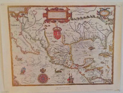
Jun 07Freeman's | Hindman[MAP]. ORTELIUS, Abraham. Americae Sive Novi Orbis, Nova Descriptio. 1573.$1,000(1 bid)
5 days LeftThe Bidder AuctionsJerusalem city map - ie heilige statt Jerusalem contrafehtet nach form und gestalt - 16th century$100
Jun 01Trillium Antique Prints & Rare BooksSanson - Map of Canada or New France with the Great Lakes$75
Featured4 days LeftJasper52c1720 World showing Dutch East India Co possessions. CA as a island. By J.Malherbe$600


![Munster DES NOUVELLES ISLES. Woodcut map.: [New World] DES NOUVELLES ISLES, COMMENT, QUAND & PAR QUI ELLES ONT ESTE TROUVEES. Woodcut map from Sebastian Munster’s “Cosmographia…” Text below woodcut and on verso. Several French editions](https://p1.liveauctioneers.com/179/85723/44107983_1_x.jpg?height=310&quality=70&version=1456876561)


![World.- Münster (Sebastian) Figura del Mondo Universale, [c. 1575].: World.- Münster (Sebastian) Figura del Mondo Universale, Ptolemaic woodcut map of the ancient world, prior to the discovery of the New World with an enclosed Indian Ocean and multiple lake source](https://p1.liveauctioneers.com/5458/260724/135800515_1_x.jpg?height=310&quality=70&version=1662479034)


![MAP, Balkans, Munster: Istria Peninsula, Croatia. Sebastian Munster, [Title on Verso] Hysterreich, from Cosmographei oder Beschreibung aller Länder, 1556 (published). Hand Color. Woodblock map of Istria, in present-day Cro](https://p1.liveauctioneers.com/6576/320593/172252548_1_x.jpg?height=310&quality=70&version=1708729193)
![MUNSTER, SEBASTIAN Tabula Britanniae. [Basel: circa 1571]. Woodcut map on laid paper set with a: MUNSTER, SEBASTIAN Tabula Britanniae. [Basel: circa 1571]. Woodcut map on laid paper set with a trapezoidal border, paginated 120/121, with signature mark k5 to lower corner, Latin text on verso. Shee](https://p1.liveauctioneers.com/292/250642/130213678_1_x.jpg?height=310&quality=70&version=1654271664)


![Munster map of World 1550: Heading: (Maps) Author: Münster, Sebastian Title: Das Erst General/inhaltend die beschzeibung und den Circkeldes gantzen Erdtrichs und Moze Place Published: [Basle] Publisher: Date Published: </](https://p1.liveauctioneers.com/642/299378/159362943_1_x.jpg?height=310&quality=70&version=1692570425)


![[MAP]. ORTELIUS, Abraham. Americae Sive Novi Orbis, Nova Descriptio. 1573. (1 of 2)](https://p1.liveauctioneers.com/197/329395/177650534_1_x.jpg?height=282&quality=70&version=1715364962)


![[MAP]. SPEED, John. A New Mappe of the Romane Empire. 1676. (1 of 2)](https://p1.liveauctioneers.com/197/329395/177650541_1_x.jpg?height=282&quality=70&version=1715364962)


