Sold2022London.- Bowles (Carington) Bowles's New Pocket Plan ofLondon.- Bowles (Carington) Bowles's New Pocket Plan of the Cities of London & Westminster; with the Borough of Southwark; Comprehending the New Buildings and other Alterations to the year 1783, showiSee Sold Price
Sold2018London.- Mogg (Edward) An Entire New Plan of the CitiesLondon.- Mogg (Edward) An Entire New Plan of the Cities of London & Westminster with the Borough of Southwark, Comprehending the New Buildings and other Alterations, to the Year 1805, showing from HydSee Sold Price
Sold20221720 J. STRYPE HAND-COLORED PLAN OF LONDONGenuine 18th century hand-colored copper engraving, titled "A New Plan of the City of London, Westminster, and Southwark". Published in A Survey of London by John Strype (1720); attributed to engraverSee Sold Price
Sold2023 [MAPS]. BOWLES, Carington (1724-1793). Bowles's Reduced New...[MAPS]. BOWLES, Carington (1724-1793). Bowles's Reduced New Pocket Plan of the Cities of London and Westminster… London: Bowles and Carver, 1798. Engraved map (fully opened, 394 x 552 mm) with cSee Sold Price
Sold2018Wards of London from Stow's Survey 1754Heading: Author: Stow, John Title: Eight plans from John Stow's "A Survey of the Cities of London and Westminster" Place Published: London Publisher: Date Published: 1754-55 DescriptiSee Sold Price
Sold2022London.- Lediard (Thomas) A Plan of Part of the Ancient City of Westminster, from College Street toNO RESERVE London.- Lediard (Thomas) A Plan of Part of the Ancient City of Westminster, from College Street to Whitehall, and from the Thames to St. James's Park, engraved plan by Fourdrinier, on laidSee Sold Price
Sold2020Grp: 10 Maps of British Cities w/ 1 Map VeniceGroup of maps of British cities. Includes one map of Birmingham; two road maps for the London area: "A Map of the New Roads & c. from Westminster Bridge" and "A Plan of the intended New Road from PadiSee Sold Price
Sold2023John Rocque City of London Westminster, Southwark Map/ 1746Description: FOUR FRAMED GLASS PANELS: An exact survey of the city's of London and Westminster, ye borough of Southwark and the country near ten miles round: begun in 1741, finished in 1745, and publiSee Sold Price
Sold2017Harrison: Antique Map Plan of London, 1776Title/Content of Map: 'A new and complete plan of London, Westminster and Southwark, with the additional buildings to the year 1777' Date Printed: 1776 Image Size: Approx 29.5 x 51.0cm, 11.5 x 20 inchSee Sold Price
Sold2018London.- Cary (John) Cary's New Pocket Plan of London,NO RESERVE London.- Cary (John) Cary's New Pocket Plan of London, Westminster and Southwark ..., showing from Islington to Lambeth, and Hyde Park across to Mile End, with references to Public Offices,See Sold Price
Sold2023ROCQUE, John (circa 1709-1762) and Richard PARR. A single sheet from An Exact Survey of the City'sROCQUE, John (circa 1709-1762) and Richard PARR. A single sheet from An Exact Survey of the City's of London Westminster ye Borough of Southwark. London, 29 April 1746. Engraved map of Central London,See Sold Price
Sold20241812 Cary Map of London -- Cary's New and Accurate Plan of London and Westminster, the Borough ofTitle: 1812 Cary Map of London -- Cary's New and Accurate Plan of London and Westminster, the Borough of Southwark and Parts Adjacent Cartographer: J Cary Year / Place: 1812 London Map Dimension (in.)See Sold Price
Sold2022A RARE 18TH CENTURY MAHOGANY FRAMED LARGE TRIPLE FOLDING SCREEN DEPICTING A DETAILED MAP OF THE CITYA RARE 18TH CENTURY MAHOGANY FRAMED LARGE TRIPLE FOLDING SCREEN DEPICTING A DETAILED MAP OF THE CITY OF LONDON from a bound volume of the Cities of London and Westminster and Southwark and ten-mile raSee Sold Price
Sold2023LONDON MAP:LONDON MAP: LONDON MAP: Cary's New and Accurate Plan of London and Westminster, the Borough of Southwark and parts adjacent: viz. Kensington, Chelsea, Islington, Hackney, Walworth, Newington &c with aSee Sold Price
Sold2020[Maps & Atlases] [London] Stow, John, Group of 5 maps[Maps & Atlases] [London] Stow, John Group of 5 maps of London London, 1754-55. Approximately 18 1/2 x 15 7/8 inches. Five matted maps from Stow's "A Survey of Cities of London and Westminster and theSee Sold Price
Sold202418th c. London Drunkenness & Prostitution[By a Citizen of London to a Member of Parliament.] THE VICES OF THE CITIES OF LONDON AND WESTMINSTER. TRAC'D FROM THEIR ORIGINAL. London: for Charles Corbett, n.d. (1751?) 8vo. [2], 52 pp., wanting hSee Sold Price
Sold2022THOMAS MALTON London Wall Aquatint EtchingTHOMAS MALTON London Wall Aquatint Etching, vintage possibly antique, from Malton’s aquatint series ‘A Picturesque Tour Through the Cities of London and Westminster’, inscribed ‘London Wall. PSee Sold Price
Sold2018London - Malton, Thomas 1800 HC Print of Fitzroy SquareHand Coloured Aquatint Published 1792-1801, London for "A Picturesque Tour Through the Cities of London and Westminster" by Thomas Malton. Paper Size: 16.5 x 12.5 inch (42 x 32cm) Tiny chip to top marSee Sold Price
Sold2023Anthony Klitz 1914-2000 London Landscape PaintingAnthony (Tony) Klitz (British, 1914-2000). An original oil painting on canvas. An Impressionist city landscape of London with Westminster, Big Ben, London Bridge, and boats on the River Thames. ArtistSee Sold Price
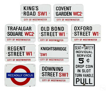
Sold2022Garnier & Co 10 Enameled Metal London Street SignsAn estate collection with 10 enameled metal street nameplate signs, including nine (9) vintage mid 20th Century City of Westminster (London) street and London Underground (subway tube) station signs,See Sold Price
Sold2023Anthony Klitz 1914-2000 London Landscape PaintingAnthony (Tony) Klitz (English, 1914-2000). An original oil painting on canvas. An Impressionist city landscape of London with Westminster, Big Ben, London Bridge, and boats on the River Thames. ArtistSee Sold Price
Sold2018Civil War plan of London as fortified by Parliament inTITLE/CONTENT OF MAP: 'A plan of the city and environs of London as fortified by order of Parliament in the years 1642 & 1643' Date: 1776 IMAGE SIZE: Approx 21.5 x 33.5cm, 8.5 x 13.25 inches (Large) TSee Sold Price
Sold2022Britain.- [Norden (John)] [Speculum Britanniae], [1593].Britain.- [Norden (John)] [Speculum Britanniae], lacking title, lacking map of City of London, folding woodcut maps of Westminster and Middlesex both present, the latter trimmed along lower edge withSee Sold Price
Sold2021Bartholomew, John 1904 Lot of 3 Maps of ScotlandIncl Density of Population Central Scotland, Parliamentary Representation of Scotland, and Glasgow City Plan. Lithograph Maps Published 1904, London for "The Survey Gazetteer of the British Isles" UncSee Sold Price
Jun 06Freeman's | HindmanDICKENS, Charles (1812-1870). A Tale of Two Cities. London: Chapman & Hall, 1859.$500
Jun 07Freeman's | HindmanDICKENS, Charles. A Tale of Two Cities. 1859. FIRST EDITION, later issue.$150(1 bid)
Jun 06Freeman's | HindmanELIOT, T.S. (1888-1945). The Family Reunion. London: Faber & Faber Limited, 1939.$250
4 days LeftDawsons AuctioneersAfter Samuel Buck (1696 - 1779) and Nathaniel Buck (fl. 1724 - 1759), A Panorama of London and the£280
Jun 04TimeLine Auctions Ltd.Viking Age Scandinavian Gold Filigree Pendant with Interlace Motif£320(4 bids)
4 days LeftForum AuctionsLondon, Whitechapel.- Manning (Joseph, surveyor) A Plan of an Estate situate in the Parish of St£600
2 days LeftJasper52SOUVENIR OF SCOTLAND Its Cities Lakes and Mountains 1891Hardcover T. Nelson&Sons$420


![[MAPS]. BOWLES, Carington (1724-1793). Bowles's Reduced New...: [MAPS]. BOWLES, Carington (1724-1793). Bowles's Reduced New Pocket Plan of the Cities of London and Westminster… London: Bowles and Carver, 1798. Engraved map (fully opened, 394 x 552 mm) with c](https://p1.liveauctioneers.com/928/301544/160920966_1_x.jpg?height=310&quality=70&version=1694462960)


![[Maps & Atlases] [London] Stow, John, Group of 5 maps: [Maps & Atlases] [London] Stow, John Group of 5 maps of London London, 1754-55. Approximately 18 1/2 x 15 7/8 inches. Five matted maps from Stow's "A Survey of Cities of London and Westminster and the](https://p1.liveauctioneers.com/65/168030/84729856_1_x.jpg?height=310&quality=70&version=1588715715)
![18th c. London Drunkenness & Prostitution: [By a Citizen of London to a Member of Parliament.] THE VICES OF THE CITIES OF LONDON AND WESTMINSTER. TRAC'D FROM THEIR ORIGINAL. London: for Charles Corbett, n.d. (1751?) 8vo. [2], 52 pp., wanting h](https://p1.liveauctioneers.com/3532/326332/175680390_1_x.jpg?height=310&quality=70&version=1713150771)


![Britain.- [Norden (John)] [Speculum Britanniae], [1593].: Britain.- [Norden (John)] [Speculum Britanniae], lacking title, lacking map of City of London, folding woodcut maps of Westminster and Middlesex both present, the latter trimmed along lower edge with](https://p1.liveauctioneers.com/5458/245864/127550519_1_x.jpg?height=310&quality=70&version=1650894030)


![[Paris] - Stanford, Edward (1 of 1)](https://p1.liveauctioneers.com/94/330664/178342455_1_x.jpg?height=282&quality=70&version=1716466933)


