Sold2018Janssonius Map of East coastJANSSONIUS, Joannes. Nova Anglia Novum Belgium et Virginia. Copperplate engraving. Amsterdam, 1636 (first State). Burden 247. 18 3/4 x 22 1/2 inches sheetSee Sold Price
Sold2016*ZATTA, ANTONIO(18th C. Italian) Handcolored engraved map illustrating Maryland, Jersey, Delaware, Virginia and Carolina settlements, approximate plate size 13 1/4" x 17 1/2", frame 16" x 22 1/2".See Sold Price
Sold2016Map of West Virginia, 1902Title: Map of West Virginia Original engraving by George Cram Date: 1902 Dimensions: 14 1/2 x 22 inches No Reserve: This lot starts at $1 and has no reserve as a courtesy so that collectors can determSee Sold Price
Sold20211720 c. Homann Map of Central Germany Near Fulda -- S.Title: 1720 c. Homann Map of Central Germany Near Fulda -- S. R. I. Principatus Fuldensis in Buchonia… Cartographer: J Homann Year / Place: 1720 c., Nurnberg Map Dimension (in.): 19.1 X 22.6 in. ThiSee Sold Price
Sold2023GEORGE CRAM'S AMERICAN ATLAS OF THE UNITED STATESGEORGE CRAM'S AMERICAN ATLAS OF THE UNITED STATESGeorge F. Cram, proprietor of the Western Map Depot, Chicago, IL, 1878. Color maps within.22.1 x 17.6 in. (56.1 x 44.7 cm.)See Sold Price
Sold2015Kingdom of IrelandJohn Speed (1552-1629). Engraved map. London: 1610 (1676). 17 1/4 x 22 inches. A rare, early printing of John Speed’s renowned map of Ireland. The map is decorated with a panel of costume figures deSee Sold Price
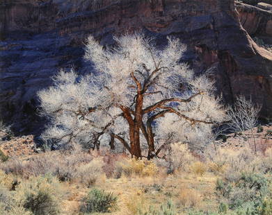
Sold2015CHRISTOPHER BURKETT (American b. 1951) A PRINT,CHRISTOPHER BURKETT (American b. 1951) A PRINT, "Cottonwood and Light, Utah 1987," on paper, signed L/R. 18" x 22 1/2"See Sold Price
Sold2018F Bridgman Teaching of Koran Oil on CanvasFrederick Arthur Bridgman (American, 1847-1928), 'Teaching of Koran', Orientalist painting, oil on canvas, signed L/R, 22" x 30" (sight), frame 28 1/4" x 36".See Sold Price
Sold2023MITCHELL'S NEW MAP of TEXAS, OREGON & CALIFORNIA1846 Philadelphia, S. Augustus Mitchell. hardcover leather bound. 5 1/4 x 3 1/4 inches. Map unfolded 22 x 20 1/2 inches and presented in a custom frame 23 1/2 x 22 inches (overall)See Sold Price
Sold2020Laurie & Whittle Map of AmericaLAURIE & WHITTLE (Late 18th Century)The United States of America...Engraved map with original hand color in full.London: Laurie & Whittle, 1794.20 1/4" x 22 1/2" sheet.The first British map to show thSee Sold Price
Sold202219th Century View of Harper's Ferry, Virginia, from the Potomac19th Century View of Harper's Ferry, Virginia, from the Potomac Oil on canvas. 22 1/2 x 30 in. From an Upstate New York Museum.See Sold Price
Sold2022Colom's Map of the Western Indian Ocean, c. 1658COLOM, Arnold (1624-1668). Oost Indien van Cabo de Bona Esperanca tot Ceilon. Engraved map with original hand color in outline. Amsterdam, c. 1658. 22 1/4" x 25 1/2" sheet. Colom's Zee Atlas is amongSee Sold Price
Sold2018Colton Map of Nebraska and KansasCOLTON, Joseph H. (1800-1893). Nebraska & Kansas. Lithograph with handcolor in part. New York, 1857. 30 1/2 x 22 1/2 inches sheet, 40 x 32 inches framed Striking map of Kansas and Nebraska, includingSee Sold Price
Sold2024Abraham Ortelius, Map of ChinaAbraham Ortelius (Dutch, 1527-1598), "Chinae, olim Sinarum regionis nova descriptio. auctore Ludouico Georgio", hand-colored engraving. Creases. Sight size: 15"h x 19"w Overall: 22-1/2"h x 26-1/2"w PrSee Sold Price
Sold20202 Virginia Beresford ink washVirginia Beresford (American 1904-1995)- Savoy Dancers- 2 ink wash on paper, 1938, both signed Beresford in pencil, 1 framed. 22 x 15'' ea.See Sold Price
Sold2023O. Winston Link, "Birmingham Special ..."Ogle "O" Winston Link (American, 1914-2001). "Birmingham Special at Rural Retreat, Virginia, 1957". Gelatin silver photograph print, 1987. Sight: 15 1/2" x 19 1/4". Frame: 22 1/2" x 26 1/4". PhotograpSee Sold Price
Sold2019Federal inlaid walnut cellarette-on-stand, SouthernFederal inlaid walnut cellarette-on-stand Southern States, possibly Virginia or North Carolina, circa 1800 The interior fitted with bottle compartments. H: 36 in. W: 15 in. L: 22 1/2 in. PROVENANCE:CoSee Sold Price
Sold2022Linschoten, Delineatio orarum maritimarum 1596LINSCHOTEN, Jan Van (1563-1611). Delineatio orarum maritimarum, terrae vulgo indigetatae terra do Natal. Engraved map. Amsterdam, 1596. 15 5/8" x 22 1/4" sheet. Comparable: Swann Galleries, 2013 - $2,See Sold Price
Sold2022Rufino Tamayo, Perfil de HombreRufino Tamayo Perfil de Hombre 1979etching in colors on Guarro paper 29.75 h × 22 w in (76 × 56 cm) Signed and numbered to lower edge 'H/C 1/15 R Tamayo'. This work is hors commercSee Sold Price
Sold2020Keith Haring - Untitled, Drawing on New York MapKEITH HARING (1958-1990) Untitled (Crawling Baby) Ink on paper 27 1/2" x 22" Signed lower left side and inscribed "To Mike" Drawn on a 1983 New York City Transit Authority mapSee Sold Price
Sold2018Guy Pene Du Bois, Girls Wading with DogGuy Pene Du Bois (American, 1884-1958), 'Two Girls Wading with Dog' 1934, oil on canvas, signed L/R, 16 1/8" x 11 7/8", framed 22" x 17 3/4", labeled Sid Deutsch Gallery, New York City. Provenance: ShSee Sold Price
Sold2024Willem Blaeu, Map of The AmericasAmsterdam, 1617. Together with "Early Maps" by Tony Campbell, Abbeville Press and "The United States in Old Maps and Prints, Eduard Van Ermen. 3 pieces Sight size: 16-1/2"h x 22"w Overall: 23-1/2"h xSee Sold Price
Sold2024R. C. Gorman, Two Women with Pots, 1973R. C. Gorman(Diné [Navajo], 1931 - 2005)Two Women with Pots, 1973oil pastel on papersigned lower left: R. C. Gorman / 197322 x 28 in. (55.9 x 71.1 cm.), frame: 34 1/2 x 40 1/2 x 1 in. (87.6 x 1See Sold Price
Sold2021Richard MacDonald, Flutist, 1993Richard MacDonald(b. 1946)Flutist, 1993bronze, edition 17 of 175inscribed near base: 17/175 / © R. MacDonaldWith Base: 22 x 13 1/2 x 8 1/8 in. (55.88 x 34.29 x 20.64 cm.) Private Collection, New MexiSee Sold Price
2 days LeftBertolami Fine Art s.r.l.D'Annunzio, Gabriele (Pescara, 12 March 1863 – Gardone Riviera, 1 March 1938)€800
5 days LeftFreeman's | Hindman[CIVIL WAR]. Manuscript Confederate pass "to go to Manassas Junction and return." Signed by Richard$200
Jun 08Simpson Galleries, LLC.FRANCISCO ZUNIGA (Mexican 1912-1998) A PRINT, "Soledad Acostada," 1973$300(1 bid)
Jun 04TimeLine Auctions Ltd.Post Medieval Enamelled Gold Memento Mori Ring with Skull and Skeletons£7,000
Jun 08Simpson Galleries, LLC.ANCEL E. NUNN (American/Texas 1928-1999) A PAINTING, "The Edge of Eden," 1983$5,000
Jun 08Early American History Auctions1720 Colonial Northumberland County Virginia Manuscript Deed and Map Plot$400
Jun 12Dan Morphy AuctionsMAP OF THE CHOCTAW NATION, INDIAN TERRITORY - COAL AND ASPHALT SEGREGATION 1903$100
2 days LeftJasper521823 MAP of WINDWARD ISLAND GEOGRAPHICAL STATISTICAL HISTORICAL antique 17.5x 22$75


![R. C. Gorman, Two Women with Pots, 1973: R. C. Gorman(Diné [Navajo], 1931 - 2005)Two Women with Pots, 1973oil pastel on papersigned lower left: R. C. Gorman / 197322 x 28 in. (55.9 x 71.1 cm.), frame: 34 1/2 x 40 1/2 x 1 in. (87.6 x 1](https://p1.liveauctioneers.com/317/318020/170667499_1_x.jpg?height=310&quality=70&version=1706748100)


![[CIVIL WAR]. Manuscript Confederate pass "to go to Manassas Junction and return." Signed by Richard (1 of 2)](https://p1.liveauctioneers.com/197/329785/177758374_1_x.jpg?height=282&quality=70&version=1715625218)


