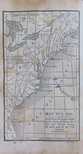
Early English map of U.S. 1783
Similar Sale History
View More Items in Maps & AtlasesRelated Maps & Atlases
More Items in Maps & Atlases
View MoreRecommended Transportation & Travel Collectibles
View More


Item Details
Description
Heading:
Author: Kitchin, Thomas
Title: Map of the United States in North America: with the British, French and Spanish Dominions adjoining, according to the Treaty of 1783.
Place Published: London
Publisher:T. Cadell
Date Published: May 1, 1783
Description:
Author: Kitchin, Thomas
Title: Map of the United States in North America: with the British, French and Spanish Dominions adjoining, according to the Treaty of 1783.
Place Published: London
Publisher:T. Cadell
Date Published: May 1, 1783
Description:
Copper engraved folding map. 44.5x53 cm (17½x21").
One of the earliest English maps to officially acknowledge the United States. The western border is on the Mississippi River, with the states of Georgia, South Carolina, North Carolina, and Virginia stretching from the Atlantic to the Mississippi. The map is filled with information on early settlements, forts, Indian villages and fishing banks.
Condition
General light wear, faint offsetting, clear tape strip at upper right side; very good.
Buyer's Premium
- 25%
Early English map of U.S. 1783
Estimate $500 - $800
13 bidders are watching this item.
Shipping & Pickup Options
Item located in Berkeley, CA, usOffers In-House Shipping
Local Pickup Available
Payment

Related Searches
TOP


![North America Map circa 1800s [179302]: Early map of the North American continent circa 1810. Shows the western area as New Albion, southwest Canada as New Caledonia and the Russian Possessions of western Canada and Alaska. Also noted are s](https://p1.liveauctioneers.com/2699/331495/178785793_1_x.jpg?height=310&quality=70&version=1717094933)

![WEST AFRICA Explorers' routes Senegal Ashanti. Mountains of Kong. SDUK 1857 map: Title: WEST AFRICA Explorers' routes Senegal Ashanti. Mountains of Kong. SDUK 1857 map Description: WEST AFRICA, I [Senegal River to Cape St Paul]. Engraved by J & C Walker (1857). Antique steel engra](https://p1.liveauctioneers.com/5584/330582/178266235_1_x.jpg?height=310&quality=70&version=1716924723)


![[MAP]. TODESCHI, Pietro. [Nova et Acurata Totius Americae Tabula auct. G.I. Blaeu] America quarta: [MAP]. TODESCHI, Pietro. [Nova et Acurata Totius Americae Tabula auct. G.I. Blaeu] America quarta pars orbis quam plerunq, nuvum orbem appellitant primo detecta est anno 1492 a Christophoro Columbo...](https://p1.liveauctioneers.com/197/329395/177650542_1_x.jpg?height=310&quality=70&version=1715364962)
![[MAPS]. HOMANN, Johann Baptist, HOMANN HEIRS, and Georg Matthäus SEUTTER. [Composite Atlas].: [MAPS]. HOMANN, Johann Baptist (1663-1724), HOMANN HEIRS, and Georg Matthäus SEUTTER (1678-1757). [Composite Atlas]. [Nuremberg, Augsburg, and others: Homann Heirs and others, maps dated between](https://p1.liveauctioneers.com/197/329395/177650530_1_x.jpg?height=310&quality=70&version=1715364962)


![[MAP]. ORTELIUS, Abraham. Americae Sive Novi Orbis, Nova Descriptio. 1573.: [MAP]. ORTELIUS, Abraham (1527-1598). Americae Sive Novi Orbis, Nova Descriptio. Antwerp, 1573. Engraved map with hand-coloring. Framed and double glazed, visible area 375 x 521 mm (unexamined out of](https://p1.liveauctioneers.com/197/329395/177650534_1_x.jpg?height=310&quality=70&version=1715364962)

![Set of Twelve Satirical Anthropomorphic Maps of Europe: [SATIRICAL MAPS] A set of twelve satirical anthropomorphic maps of Europe. London: circa 1868. A set of 12 (believed complete) lithographed maps by Vincent Brooks, Day & Son, London, each offering](https://p1.liveauctioneers.com/292/330597/178279264_1_x.jpg?height=310&quality=70&version=1716409282)


![[MAP]. ORTELIUS, Abraham. Turcici Imperii Descriptio.1592.: [MAP]. ORTELIUS, Abraham (1527-1598). Turcici Imperii Descriptio. Antwerp, 1592. Engraved map with hand-coloring. Matted, framed, and double glazed, sight 406 x 521 mm (unexamined out of frame). Decor](https://p1.liveauctioneers.com/197/329395/177650538_1_x.jpg?height=310&quality=70&version=1715364962)
![[MAP]. ORTELIUS, Abraham. Romani Imperii Imago. 1592.: [MAP]. ORTELIUS, Abraham (1527-1598). Romani Imperii Imago. Antwerp, 1592. Engraved map with hand-coloring. Matted, framed, and double glazed, visible area 381 x 521 mm (unexamined out of frame). 6 de](https://p1.liveauctioneers.com/197/329395/177650537_1_x.jpg?height=310&quality=70&version=1715364962)
![[MAP]. SPEED, John. A New Mappe of the Romane Empire. 1676.: [MAP]. SPEED, John (ca 1551-1629). A New Mappe of the Romane Empire. London: Basset & Chiswell, 1676. Engraved map with hand-coloring. Framed and double glazed, sight 419 x 559 mm. Decorative cartouch](https://p1.liveauctioneers.com/197/329395/177650541_1_x.jpg?height=310&quality=70&version=1715364962)

![[MAP]. ORTELIUS, Abraham. Aevi Veteris, Typus Geographicus. 1601.: [MAP]. ORTELIUS, Abraham (1527-1598). Aevi Veteris, Typus Geographicus. Antwerp, 1601. Engraved map with hand-coloring. Matted, framed, and double glazed, visible area 343 x 470 mm (unexamined out of](https://p1.liveauctioneers.com/197/329395/177650532_1_x.jpg?height=310&quality=70&version=1715364962)


