


1755 Map Partie de l'Amerique Septentrionale, qui comprend Le Cours de L'Ohio...
Similar Sale History
View More Items in Maps & Atlases


![[MAPS - COLONIAL NORTH AMERICA]. VAUGONDY, Gilles Robert de...: [MAPS - COLONIAL NORTH AMERICA]. VAUGONDY, Gilles Robert de (1688-1766). Partie de l'Amerique Septentrionale qui Compred le Cours de l'Ohio… Paris, 1755. Large hand-colored engraved map (520 x 6](https://p1.liveauctioneers.com/928/301544/160920952_1_x.jpg?height=310&quality=70&version=1694462960)


![[GREAT LAKES REGION]. ROBERT DE VAUGONDY, Didier: [GREAT LAKES REGION]. ROBERT DE VAUGONDY, Didier (1723–1786). Partie De l’Amerique Septent? qui comprend La Nouvelle France ou Le Canada. Paris, 1755. Hand–colored engraved map of ea](https://p1.liveauctioneers.com/928/212515/108628837_1_x.jpg?height=310&quality=70&version=1627420959)

![[ANTIQUE MAP] VAUGONDY NOUVELLE FRANCE-CANADA 1755: [ANTIQUE MAPS] de VAUGONDY, Robert. "CANADA PARTIE DE L'AMERIQUE SEPTENT QUI COMREND LA NOUVELLE FRANCE OU LE CANADA"Circa 1755. 61x47cm. Frame not included. Map will be removed from frame and securel](https://p1.liveauctioneers.com/8321/253807/131946553_1_x.jpg?height=310&quality=70&version=1657219161)
![[JAILLOT] MAP OF HUNGARY & SURROUNDINGS: 'Le Royaume De Hongrie Et Les Estats qui en ont este sujets....La Partie Septentrionale De La Turquie en Europe, by Alexis-Hubert Jaillot (ca. 1632-1712) and Guillaume Sanson (1633-1703), engraving wi](https://p1.liveauctioneers.com/522/124271/63207925_1_x.jpg?height=310&quality=70&version=1530290718)

![[ANTIQUE MAP] PARTIE DU NORD DE L'AMERIQUE SEPTENTRIONALE. C.1770s: [ANTIQUE MAP] PARTIE DU NORD DE L'AMERIQUE SEPTENTRIONALE. Pour Servir a L'historie Philisophique et Politique... By Rigobert Bonne (1727-1795) Map of the eastern part of North America shows the Briti](https://p1.liveauctioneers.com/8321/286473/155024526_1_x.jpg?height=310&quality=70&version=1686787412)


Related Maps & Atlases


![Carte du Golphe de Bengale'. Bay of Bengal. India Burma Ceylon. BELLIN 1746 map: CAPTION PRINTED BELOW PICTURE: Carte du Golphe de Bengale tiré de la Carte de l'Océan Oriental, Publiée par Ordre de Mgr le Comte De Maurepas [Map of the Bay of Bengal] DATE PRINTED: 17](https://p1.liveauctioneers.com/5584/329387/177649439_1_x.jpg?height=310&quality=70&version=1715717898)


More Items in Maps & Atlases
View More
![[Maps] Gio. Ant. Magnini, Italia, 1620: [Maps] Gio. Ant. Magnini, Italia, 1620, Giovanni Antonio Magnini. Italia, data in luce da Fabio suo figliuolo al Serenissimo Ferdinado Gonzaga Duca di Matoua edi Monserrato etc. Bologna, for Sebastian](https://p1.liveauctioneers.com/188/326797/176317457_1_x.jpg?height=310&quality=70&version=1713847031)
![[Maps] Martin Zeiler, Itinerarium Italiae, 1640: [Maps] Martin Zeiler, Itinerarium Italiae, 1640, Martini Zeilleri. Itinerarium Italiae Nov-Antiquae: oder, Raiss-Beschreibung durch Italien, Matthaus Merian, Frankfurt, 40 plates, most double-page, in](https://p1.liveauctioneers.com/188/326797/176317459_1_x.jpg?height=310&quality=70&version=1713847031)


![[MAP]. TODESCHI, Pietro. [Nova et Acurata Totius Americae Tabula auct. G.I. Blaeu] America quarta: [MAP]. TODESCHI, Pietro. [Nova et Acurata Totius Americae Tabula auct. G.I. Blaeu] America quarta pars orbis quam plerunq, nuvum orbem appellitant primo detecta est anno 1492 a Christophoro Columbo...](https://p1.liveauctioneers.com/197/329395/177650542_1_x.jpg?height=310&quality=70&version=1715364962)


Recommended Transportation & Travel Collectibles
View More


Item Details
Description
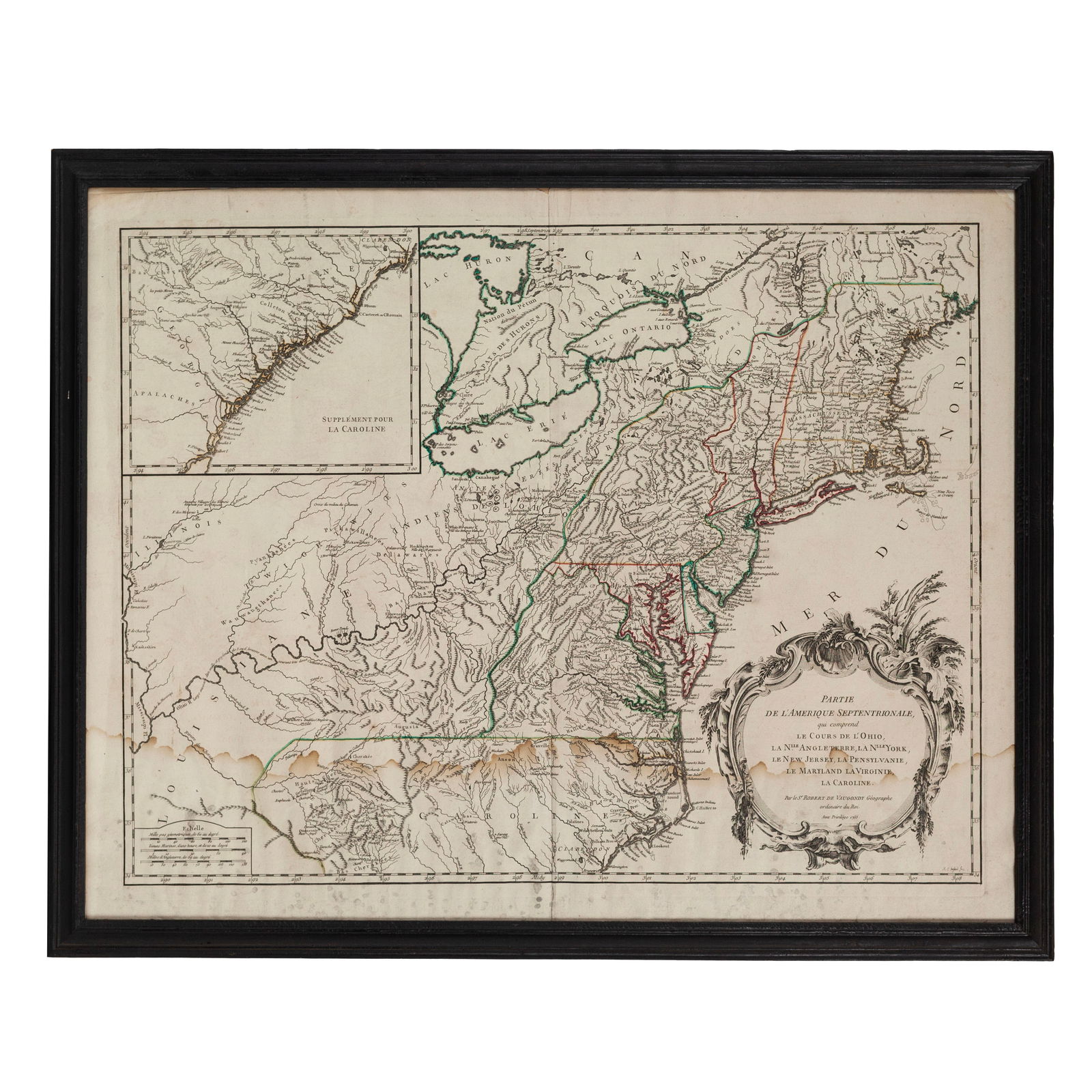
Didier Robert de Vaugondy. Partie de l'Amérique Septentrionale, qui comprend Le Cours de L'Ohio, La Nlle. Angleterre, La Nlle. York, Le New Jersey, La Pennsylvanie, Le Maryland La Virginie, La Caroline. From Atlas Universel. Paris, 1755. ## x ## in. Engraved map with hand coloring. Inset of the coast of Georgia and the Carolinas.
An attractive mid-18th century hand-colored engraved map of the American colonies between the Atlantic ocean and the Ohio and Mississippi rivers. The trans-Allegheny and Great Lakes were hotly contested by colonial powers, erupting in the French & Indian War.
The map shows the confluence of the Allegheny and Monongahela rivers, known as the Forks of the Ohio, and the location of Fort Duquesne.
Based on the map by John Mitchell published the same year.
[Maps, Cartography, Books, Manuscripts,
Buyer's Premium
- 23%
1755 Map Partie de l'Amerique Septentrionale, qui comprend Le Cours de L'Ohio...
Estimate $500 - $750
31 bidders are watching this item.
Shipping & Pickup Options
Item located in Columbus, OH, usSee Policy for Shipping
Payment
Accepts seamless payments through LiveAuctioneers

Related Searches
TOP