Sold2022(CIVIL WAR.) P.S. Duval & Son. Military Map of the United States & Territories(CIVIL WAR.) P.S. Duval & Son. Military Map of the United States & Territories Showing the Location of the Military Posts, Arsenals, Navy Yards, & Ports of Entry. Hand-colored lithographed pocket mapSee Sold Price
Sold2022Civil War Military map - scarce territorial bordersThe Johnson and Ward atlas company produced two memorable, double-page Civil War maps of the United States. This is the more desirable issue, showing the state and territory borders instead of the MilSee Sold Price
Sold20211861 Colton United States Map with Civil War MilitaryTitle: 1861 Colton United States Map with Civil War Military Stations -- Colton's United States Shewing the Military Stations Forts &c. Cartographer: J Colton Year / Place: 1861, New York Map DimensioSee Sold Price
Sold2022United States military map during civil war. 1862 byTitle: United States military map during civil war. 1862 by Johnson Date/Period: 1862 Materials: Steel plate engraved Size: 19" x 27" Shows inserts of eight southern ports, interesting boundaries of tSee Sold Price
Sold20171862 Johnson Civil War Military Map of US1862 Johnson Civil War Military Map of US -- Johnson's New Military Map of the United States Showing the Forts, Military Posts &c. all the Military Divisions with Enlarged Plans of Southern Harbors…See Sold Price
Sold2019United States. Civil war era military map. ShowingTitle/Content of Map: United States. Civil war era military map. Showing southern ports Date: 1863 Cartographer: By Johnson & Ward. From, Johnson’s New Illustrated Family Atlas Size: 18x 26 1/4”.See Sold Price
Sold20201861 Civil War military map in full hand-colorLarge format, double-page “Johnson’s New Military Map of the United States showing the Forts, Military Posts &c. with Enlarged Plans of Southern Harbors” by Johnson and Ward. Original and vividSee Sold Price
Sold20211861 Civil War Military Map of the U.S.Johnson's New Military Map of the United States. NY: Johnson & Browning, 1861. 17.5 x 24", in 26.25 x 32.5" frame, under glass.See Sold Price
Sold2017Johnson: Antique 1st Edition Civil War Military Map1st edition Johnson’s Civil War Military Map, Johnson & Browning. Scarce 1861 map by A. J. Johnson showing the military deportment of the United States in 1860, just before war broke out in the statSee Sold Price
Sold2021U. S. TERRITORY STILL UNDER INSURRECTIONARY CONTROLCivil War Dated Wood Engraved Map MAP SHOWING THE EXTENT OF UNITED STATES TERRITORY STILL UNDER INSURRECTIONARY CONTROL, Harper's Weekly, June 28, 1862 (Civil War, Confederate States, Rebels, SuccessiSee Sold Price
Sold20182 Colton Civil War Maps, Military Stations & Forts, 3Two (2) Colton Civil War maps, 3 items total. 1st item: J.H. Colton, Civil War era map of the United States showing Military Stations and Forts, prepared for The Rebellion Record, New York: G.P. PutnaSee Sold Price
Sold2017Civil War Era Map of the United StatesMap of the United States and Territories. Henry F. Walling (1825 - 1889) & Ormando W. Gray (fl. 1860 – 1880). Lithographed Map. Boston, 1871. 17 x 25 1/2 inches sheetSee Sold Price
Sold2017Civil War Map of Gen. Sherman's Marches, 1865Map: 1865 US War Dept. Civil War Map of Gen. Sherman's Marches -- Military Map Showing the Marches of the United States Forces Under the Command of Maj. Genl. W.T. Sherman U.S.A. during the Years 1863See Sold Price
Sold20191862 1ed War with South CIVIL WAR Military Tomes1862 1ed War with South CIVIL WAR Military Tomes Illustrated Gettysburg MAPS The American Civil War played an important role in the expansion and growth of book publication in the United States, as peSee Sold Price
Sold20201892 Cowles Civil War Map of Battles and Marches byTitle: 1892 Cowles Civil War Map of Battles and Marches by Gen. Sherman 1863-5 -- Military Map of the Marches of the United States Forces Under Command of Maj. Gen. W. T. Sherman, U.S.A. During the YeSee Sold Price
Sold2022Late 19thc United States Military Campaign MapInteresting late 19th Century fold out, miltary campaign map of The United States during The Civil War, Battle of Antietam, by Hugh Rees, Ltd. Plan No. 13. Map pinpoints - West Point, Charleston, NewSee Sold Price
Sold2015History Of The Civil War In The United StatesWood, W. Birkbeck. History of The Civil War In The United States... NY: Putnam's Sons. Includes Thirteen maps and Eleven (11) plans. Inv. 72See Sold Price
Sold2019Colton's Civil War map of the United States 1862Heading: (Maps) Author: Colton, J.H. Title: Colton's United States Showing the Military Stations, Forts &c. Place Published: New York Publisher: Date Published: 1862 Description:See Sold Price
Sold2022JOHN TALLIS (1817-1876) AN AMERICAN CIVIL WAR MAP, "United States," LONDON, CIRCA 1863,JOHN TALLIS (1817-1876) AN AMERICAN CIVIL WAR MAP, "United States," LONDON, CIRCA 1863, hand-colored lithograph on wove paper showing, "Federal, Non Slave Holding States (Red); Border, Slaveholding (BSee Sold Price
Sold20221864 Civil War MAP United States Statistics Commerce1864 Civil War MAP United States Statistics Commerce American Trade Gold Silver The United States Department of Treasury published this Civil War-era report analyzing the commerce of the US GovernmentSee Sold Price
Sold2022AN AMERICAN CIVIL WAR ERA MAP, "United States of North America (Eastern & Central)," LONDON,AN AMERICAN CIVIL WAR ERA MAP, "United States of North America (Eastern & Central)," LONDON, 1861-1873, THEODORE ETTLING (b. 1823), hand colored lithograph on paper, by T. Ettling, published by CasselSee Sold Price
Sold2021CIVIL WAR-ERA JOHNSON'S MILITARY MAP UNITED STATESFramed engraving with color on paper, "Johnson's New Military Map of the United States, Showing the Forts, Military Posts & c., with Enlarged Plans of Southern Harbors from Authentic Data Obtained atSee Sold Price
Sold2021Civil War Geographical Boundary mapDefinitive map of the geographical boundaries between the Union and Confederate armies. Opens a window into the state of the U. S. during the height of the Civil War. “Map of the United States oSee Sold Price
Sold2017Civil War Era Map of the United StatesUnited States. Taliaferro Preston Shaffner (1811 – 1881). Lithographed Map. London: Schaffner, 1862. 12 1/4 x 18 1/2 inchesSee Sold Price
Jul 14Schilb Antiquarian Rare Books1928 Life of Abraham Lincoln 1ed SLAVERY Civil War Albert Beveridge 2v SET$1
Jul 04Weatherham Estate TreasuresAbraham Lincoln Bronze Bust Sculpture On Marble Base - Signed Original - 10lbs$400
Jun 23Schilb Antiquarian Rare Books1890 1ed Confederate Memoirs of Joseph Johnston & Jefferson Davis Civil War CSA$66(3 bids)
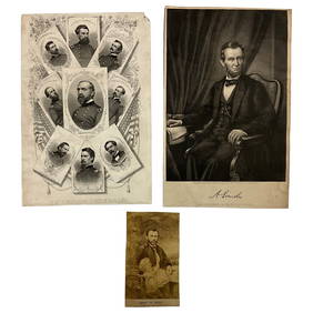
Jun 22Lakeshore Event CenterEphemera, Civil War Generals, Abraham Lincoln, Ulysses Grant, Lot of 3$30(1 bid)
Jun 23Schilb Antiquarian Rare Books1918 Robert E Lee Civil WAR Confederate General CSA Battles MAPS Illustrated$29(4 bids)
Jun 23Schilb Antiquarian Rare Books1860 Political Textbook 1ed SLAVERY Abe Lincoln Douglass Civil War Government$62(4 bids)
5 days LeftBazaar of PersiaUS Half dollar 1922 100th anniversary Birth of Ulysses S. Grant Silver coin$400
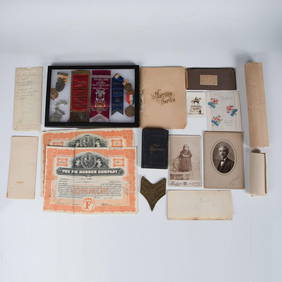
Jul 06Case Antiques, Inc. Auctions & Appraisals7 Stephens and Davis CSA Items inc. ALS, Bust, CDVs and Seals$150(1 bid)
Jul 07Case Antiques, Inc. Auctions & Appraisals3 Civil War Era Photos, incl. Rose O'Neal Greenhow, poss. Jeff Davis$150
Jun 26University ArchivesCapture of Jefferson Davis: “Mr. Davis tried to escape…with a ladies waterproof$1,600
23 hrs LeftActivity AuctionsJefferson Davis Autograph Signed Civil War Confederate President Framed (JSA LOA)$800
Jun 26University ArchivesSigned Parole Order for Pvt. Adrian Fowlkes, Co. G, 1st Virginia Cavalry$200