Sold2019George Cram’s "Rail Road Map, Texas and IndianGeorge Cram’s "Rail Road Map, Texas and Indian Territory," 1900, H.- 18 3/8 in., W.- 26 3/4 in.See Sold Price
Sold2018Cram Map of TexasCRAM, George F (1842-1928). Railroad and county map of Texas. Lithograph with handcolor, with original black slipcase on the verso. Chicago, 1876. 17 3/4 x 24 inches sheet, 28 x 33 inches framedSee Sold Price
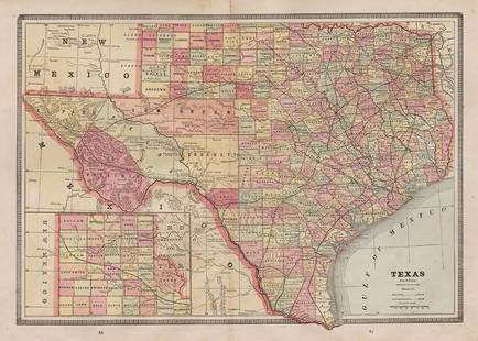
Sold20221st ed. near pristine McNally map of Texas & Ind. Terr., 1881Highly detailed and scarce large format railroad map, one of the best of the period. Rand, McNally & Co.’s Texas and Indian Territory, dated 1881 (first edition). This great map depicts railroadSee Sold Price
Sold2022Uncommon Texas/Indian Territory RR map, 1890Unusual map of Texas and Indian Territory by McNally showing highly detailed picture of Native American tribe locations in Indian Territory. Presents a thorough overview of railroad lines in the regioSee Sold Price
Sold2021Desirable Texas w/truncated Indian Terr., c1893Cerograph engraving is a uniquely striking map of Texas and a truncated Indian Territory. It was engraved by Fisk & Company of New York and published c1893 by Hunt & Eaton. Shows railroad lines and raSee Sold Price
Sold20231888 Railroad map of Montana locates battlefieldsDouble-page, vertical format map of Montana from an 1888 edition of George F. Cram's Unrivaled Family Atlas. An authentic, antique map that places battlefields, Indian reservations, t towns, rivers, lSee Sold Price
Sold20221885 Two-page Railroad map of TexasCram’s 1885 double-page railroad map of Texas has exceptional printed color. Every railroad line in the state is highlighted in a heavier black line than such things as county borders, rivers anSee Sold Price
Sold2019BURLINGTON ROUTE RAILROAD BOOK AND EPHEMERA LOTThree hardback books a glass ashtray and four state railroad maps for Texas, Illinois, Alabama and Mississippi. Various sizes. We happily provide seamless in-house packing and shipping services on neaSee Sold Price
Sold2017Rand Mcnally & Co.'s Railroad Map Of West TexasRailroad Map of West Texas Rand, McNally & Co. c. 1880, 21 x 14.25 in Please note that this lot has a confidential reserve. When you leave a bid in advance of the auction, submit your maximum. Jasper5See Sold Price
Sold20201888 Texas Railroad map by Geo. CramClean map with wide margins. Nicely centered double-page format. Full light pastel color lets railroad lines show up clearly. Very light toning to edges. 12 x 17. Reserve: $65.00 Shipping: Domestic: FSee Sold Price
Sold2022(MIDWEST.) George Woolworth Colton. County & Township Railroad Map of the States of Wisconsin,(MIDWEST.) George Woolworth Colton. County & Township Railroad Map of the States of Wisconsin, Illinois, Missouri & Iowa. Large separately issued lithographed map within a decorative foliate border. 3See Sold Price
Sold2016Cram: Map of Texas, Indian TY, Colorado, 1884Map: Texas, Indian TY, Colorado Maker: George Cram Date: 1884 Origin: Chicago Size: 11.8 x 17 inches (9.5 x 12 verso) Handsomely detailed map of Texas, with the Panhandle as insert. Colorado and IndiaSee Sold Price
Sold2020Rand McNally & Co., County and Railroad Pocket MapRand McNally & Company, Indexed County and Railroad Pocket Map and Shipper's Guide of Texas, Chicago 1904 image size: 24 x 16", frame: 28 x 17.5" Fine separately published map of Texas, colored by couSee Sold Price
Sold2022Fort Worth Railroad Map, Cowboy Portrait (2)Fort Worth Railroad map illustration, ink on paper; Cowboy portrait, graphite on paper, sight: 18 x 12", frame: 27 x 21" Provenance: A San Antonio, Texas collection We happily provide seamleSee Sold Price
Sold2022FRAMED 1914 RAILROAD MAP OF MAINEPresented by the Railroad Commissioners of Maine, showing steam railroad lines only, engraved and printed by George F. Cram of New York and Chicago. In modern black bullnose frame, under glass, 42" xSee Sold Price
Sold2017Asher & Adams: Map of Indian Territory, 1874Map: Hand Colored Map of Indian Terratory Maker: Asher & Adams Date: 1874 Size: Approx. 16x22 inches First edition of this large format railroad map of IndianTerritory, from Asher & Adams' Atlas of thSee Sold Price
Sold2022Scarce railroad map of Oklahoma/Indian Territory, 1897Wonderfully preserved, large double-page map of Oklahoma during the frontier period when half of the present-day state was still called “Indian Territory.” This authentic vintage map comes from thSee Sold Price
Sold2023Crams 1909 Railroad Map of Illinois with Original CaseOne of the nicest rarities to come through our doors! This is an uber-rare Crams 1909 Railroad Map of Illinois. Started in 1867 as the firm of Blanchard and Cram, George F. Cram took full control of tSee Sold Price
Sold2020AlabamaTitle: Alabama Publication Date: 1906 Cartographer: CRAM, GEORGE F. Publisher: GEO. F. CRAM Brief Descriptions: Double page railroad map with seven pages of index. A definitive railroad map of AlabamaSee Sold Price
Sold2019AN VINTAGE MAP, "Texas and Indian Territory," SECONDAN VINTAGE MAP, "Texas and Indian Territory," SECOND QUARTER 20TH CENTURY, color engraving on paper, showing counties, cities, rail lines, and rivers. 13.25" x 10.125"See Sold Price
Sold2018Map of Railroad and County “Indian Territory"Map of Railroad and County “Indian Territory" 22" x 28" Map of Railroad and County “Indian Territory" (Rare!) shows Indian occupied Lands – Reservation in color, not dated but 1880’s likelySee Sold Price
Sold2022Scarce Texas map (eastern part) from Asher & Adams,County map of Eastern Texas extends from Louisiana west to beyond San Antonio and features the railroad system of that time. Features numerous railroads still in their infancy, along with proposed futSee Sold Price
Sold2022Scarce Texas map (western part) from Asher & AdamsLarge double-page map of Western Portion of Texas with inset of extreme western tip of the state. Shows towns, proposed railroad lines and river, including the Colorado River and the Rio Grande. The fSee Sold Price
Sold2021Map of Texas and Indian Territory - 1850'sMap of Texas and Indian Territory Cartographer: George Woolworth Colton Dated: C 1850's Type: Engraved Hand Colored Dimensions: 9 1/2 x 7 1/2" ConditiSee Sold Price
Jun 27Rail & Road AuctionsPullman Railroad China Indian Tree Butter Pat, Fruit Bowls, and Double Handle Bouillon Cup$60
Jun 27Rail & Road AuctionsPair of Buffalo China George Washington Railroad Chesapeake and Ohio Lines Ash Trays$50
Jun 28Rail & Road AuctionsTwo Buffalo China George Washington's Railroad Chesapeake and Ohio Lines Ash Tray$60
Jun 27Rail & Road AuctionsPullman Railroad China Indian Tree Dinner Plate, Bread Plate, and Calumet Bread Plate$70
Jun 27Rail & Road AuctionsScammell's Lamberton Baltimore and Ohio Railroad China Centenary Oval Turkey Platter Indian Creek 15$60
Jun 28Rail & Road AuctionsBaltimore and Ohio Railroad China Centenary Oval Turkey Platter Indian Creek - Patent Applied For$70