


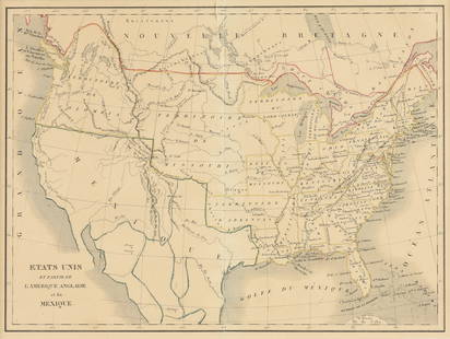
CART DU MEXIQUE ET DES ETATS UNIS D'AMERIQUE
Similar Sale History
View More Items in Maps & Atlases

![Carte des Antilles, du golfe du Mexique… Caribbean & West Indies. LAPIE 1829 map: CAPTION PRINTED BELOW PICTURE: Carte des Antilles, du golfe du Mexique et d'une partie des Etats voisins [The Antilles, the Gulf of Mexico and part of the neighbouring states] DATE PRINTED: The public](https://p1.liveauctioneers.com/5584/316569/169897396_1_x.jpg?height=310&quality=70&version=1706046386)


![Carte du Golfe du Mexique et des Isles de l'Amerique': TITLE/CONTENT OF MAP: 'Carte du Golfe du Mexique et des Isles de l'Amerique [Map of the Gulf of Mexico and the Caribbean islands]' DATE PRINTED: 1754 IMAGE SIZE: Approx 28.5 x 39.0cm, 11.25 x 15.5 inc](https://p1.liveauctioneers.com/5584/144578/73088245_1_x.jpg?height=310&quality=70&version=1561513819)


Related Maps & Atlases


![Carte de la Nouvelle Zéelande. New Zealand. Cook Strait. Thames. BONNE 1788 map: TITLE/CONTENT OF MAP: [Cook 3e Voyage] Carte de la Nouvelle Zéelande // Carte du Détroit de Cook // Baye des Isles // Baye de Tolaga // Rivière de la Tamise et de la Baye de Mercure [Co](https://p1.liveauctioneers.com/5584/332390/179262927_1_x.jpg?height=310&quality=70&version=1717528223)


More Items in Maps & Atlases
View More
![[Maps & Atlases] Oliva, Joan: Portolan Chart of the Mediterranean: [Maps & Atlases] Oliva, Joan: Portolan Chart of the Mediterranean Oliva, Joan Portolan Chart of the Mediterranean Marseille, 1615. Illuminated manuscript portolan chart on vellum, in red, blue, green,](https://p1.liveauctioneers.com/65/332523/179335172_1_x.jpg?height=310&quality=70&version=1717709445)


![Set of Twelve Satirical Anthropomorphic Maps of Europe: [SATIRICAL MAPS] A set of twelve satirical anthropomorphic maps of Europe. London: circa 1868. A set of 12 (believed complete) lithographed maps by Vincent Brooks, Day & Son, London, each offering](https://p1.liveauctioneers.com/292/330597/178279264_1_x.jpg?height=310&quality=70&version=1716409282)


Recommended Transportation & Travel Collectibles
View More


Item Details
Description
UPDATED VERSION OF DE L'ISLE'S MAP ENTITLED 'CARTE DU MEXIQUE ET DE LA FLORIDE DES TERRES ANGLOISES'. THE FIRST MAP ACCURATELY TO DEPICT THE COURSE OF THE MISSISSIPPI
Please note that this lot has a confidential reserve. When you leave a bid in advance of the auction, submit your maximum. The bidder who has submitted the highest bid wins the lot, provided the bid exceeds the reserve price.
Shipping:
Your purchase is protected:
Photos, descriptions, and estimates were prepared with the utmost care by a fully certified expert and appraiser. All items in this sale are guaranteed authentic.
In the rare event that the item did not conform to the lot description in the sale, Jasper52 specialists are here to help. Buyers may return the item for a full refund provided you notify Jasper52 within 5 days of receiving the item.
Condition
FINE. ONE TINY SPOT. ORIGINAL OUTLINE COLOUR
Buyer's Premium
- 15%
CART DU MEXIQUE ET DES ETATS UNIS D'AMERIQUE
Estimate $1,000 - $1,200
3 bidders are watching this item.
Shipping & Pickup Options
Item located in New York, NY, us$20 shipping in the US
Payment
Accepts seamless payments through LiveAuctioneers
See More Items From This Jasper52 Seller

Related Searches
TOP