


J.H. COLTON (1800-1893) A MAP, "New Map of the State of
Similar Sale History
View More Items in Maps & Atlases![[MAPS & ATLASES]. COLTON, J.H. (1800-1893). Colton's New Topographical Map of The States Of: [MAPS & ATLASES]. COLTON, J.H. (1800-1893). Colton's New Topographical Map of The States Of Virginia, Maryland and Delaware, Showing Also Eastern Tennessee & Parts Of Other Adjoining States. New York:](https://p1.liveauctioneers.com/197/265299/138516337_1_x.jpg?height=310&quality=70&version=1666051328)


![[WALL MAP]. Colton's map of the U.S.A . NY: 1853: J.H. COLTON (publisher) [WALL MAP]. Colton's map of the United States of America, the British provinces, Mexico and the West Indies. [WALL MAP]. Colton's map of the United States of America, the Briti](https://p1.liveauctioneers.com/7142/218924/116475153_1_x.jpg?height=310&quality=70&version=1636469267)


Related Maps & Atlases


![[PICTORIAL MAPS – TRAVEL]. Three Pictorial Maps. 1940s/50s....: [PICTORIAL MAPS – TRAVEL]. Three Pictorial Maps. 1940s/50s. Three brochure sized foldout maps designed for travel including: Highroads to Happiness. Mexico City: Pemex Travel Club, ca. 1940s. &#](https://p1.liveauctioneers.com/928/325952/175495561_1_x.jpg?height=310&quality=70&version=1712935174)


More Items in Maps & Atlases
View More


![[Maps] Gio. Ant. Magnini, Italia, 1620: [Maps] Gio. Ant. Magnini, Italia, 1620, Giovanni Antonio Magnini. Italia, data in luce da Fabio suo figliuolo al Serenissimo Ferdinado Gonzaga Duca di Matoua edi Monserrato etc. Bologna, for Sebastian](https://p1.liveauctioneers.com/188/326797/176317457_1_x.jpg?height=310&quality=70&version=1713847031)


Recommended Transportation & Travel Collectibles
View More


Item Details
Description
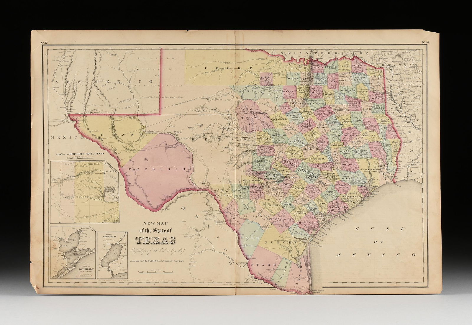
J.H. COLTON (1800-1893) A MAP, "New Map of the State of Texas," NEW YORK, CIRCA 1855, hand-colored lithograph on paper, "Compiled from J. de Cordova's large Map," and, "Published by J.H. Colton & Co., No 172 William St., New York.," plates no. 37 and no. 38 joined, the map with three inset views lower left, "Plan of the northern part of Texas," "Plan of Galveston Bay from the U.S. Coast Survey," and, "Plan of Sabine Lake," sheet: 17" x 26 1/2".
Condition
Some tears at ends, small surface stains, overall in good condition. Unframed. Simpson Galleries strongly encourages in-person inspection of items by the bidder. Statements by Simpson Galleries regarding the condition of objects are for guidance only and should not be relied upon as statements of fact and do not constitute a representation, warranty, or assumption of liability by Simpson Galleries. All lots offered are sold "AS IS."
Buyer's Premium
- 27%
J.H. COLTON (1800-1893) A MAP, "New Map of the State of
Estimate $300 - $500
19 bidders are watching this item.
Shipping & Pickup Options
Item located in Houston, TX, usSee Policy for Shipping
Local Pickup Available
Payment

TOP