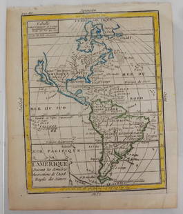
1685 Map of the Americas, w/California an Island
Similar Sale History
View More Items in Maps & AtlasesRelated Maps & Atlases
More Items in Maps & Atlases
View MoreRecommended Transportation & Travel Collectibles
View More


Item Details
Description
Historic Maps
Hand-Colored Map titled, "L'AMERIQUE SUIVANT LES DERNIERES OBSERVATIONS," of North and South America with California shown as a Separate Island
c. 1685, Copper Plate Engraved, Hand-Colored Map titled, "L'Amerique Suivant les dernieres observations de l'Acad. Royale des Sciences", showing North and South America with California shown as a Separate Island, by Denise Macquart, Choice Very Fine.
This Map has its full original margins, measuring about 6.5" x 8" including its margins. A pleasing Hand-colored Map showing North and South America with California as an island with an indented northern coastline. There are no place names on California: simply "Californie I." Published by Denise Macquart for Buffier ca. 1714, publication date 1714. This is the third state of the map, without engraver's name, and without Leon on western coast of Central America. Published in Paris. Hand-colored with outlines in yellow, green and blue.
Buyer's Premium
- 30%
1685 Map of the Americas, w/California an Island
Estimate $300 - $500
3 bidders are watching this item.
Shipping & Pickup Options
Item located in Rancho Santa Fe, CA, usOffers In-House Shipping
Payment

TOP


![Weigel map of Americas Calif. an island: Heading: (America) Author: Weigel, Christopher Title: Novi Orbis sive Totius Americae cum Adiacentibus Insulis Nova Exhibitio Place Published: Nuremberg Publisher: Date Published: [1725] <](https://p1.liveauctioneers.com/642/319971/171838511_1_x.jpg?height=310&quality=70&version=1708735483)


![[MAP]. ORTELIUS, Abraham. Africae Tabula Nova. 1592.: [MAP]. ORTELIUS, Abraham (1527-1598). Africae Tabula Nova. Antwerp, 1592. Engraved map with hand-coloring. Matted, framed, and double glazed, visible area 406 x 533 mm (unexamined out of frame). Strap](https://p1.liveauctioneers.com/197/329395/177650533_1_x.jpg?height=310&quality=70&version=1715364962)
![1894 Johnston Map of Oceania [verso] Island in the Indian Ocean and Near Africa -- Oceania [verso]: Title: 1894 Johnston Map of Oceania [verso] Island in the Indian Ocean and Near Africa -- Oceania [verso] Madagascar; Mauritius; Seychelles; Cape Town; St. Helena and Ascension Islands; Socotra; Aden](https://p1.liveauctioneers.com/5584/328338/176911535_1_x.jpg?height=310&quality=70&version=1715113718)


![Grecian Archipelago & Mediterranean Shores. Aegean islands. HUGHES 1859 map: CAPTION PRINTED BELOW PICTURE: The Grecian Archipelago. // the shores of the Mediterranean [The Adriatic, and the Black Sea] DATE PRINTED: 1859 IMAGE SIZE: Approx 37.0 x 54.0cm, 14.75 x 21.25 inches (](https://p1.liveauctioneers.com/5584/328641/177014339_1_x.jpg?height=310&quality=70&version=1715113718)

![Hyperboreorum/Septentrionalum regionum. Bertius/Langenes. Europe Arctic 1603 map: CAPTION PRINTED BELOW PICTURE: Descriptio Hyperboreorum / Septentrionalum regionu[m] descrip. [The northern latitudes] The map features the phantom island of Frisland off the coast of Greenland, south](https://p1.liveauctioneers.com/5584/328641/177014168_1_x.jpg?height=310&quality=70&version=1715113718)


![[Maps] Martin Zeiler, Itinerarium Italiae, 1640: [Maps] Martin Zeiler, Itinerarium Italiae, 1640, Martini Zeilleri. Itinerarium Italiae Nov-Antiquae: oder, Raiss-Beschreibung durch Italien, Matthaus Merian, Frankfurt, 40 plates, most double-page, in](https://p1.liveauctioneers.com/188/326797/176317459_1_x.jpg?height=310&quality=70&version=1713847031)
![[Maps] Gio. Ant. Magnini, Italia, 1620: [Maps] Gio. Ant. Magnini, Italia, 1620, Giovanni Antonio Magnini. Italia, data in luce da Fabio suo figliuolo al Serenissimo Ferdinado Gonzaga Duca di Matoua edi Monserrato etc. Bologna, for Sebastian](https://p1.liveauctioneers.com/188/326797/176317457_1_x.jpg?height=310&quality=70&version=1713847031)


