


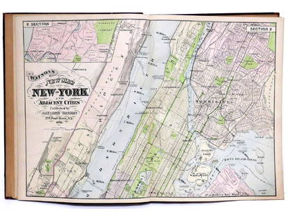
"Atlas Of The Hudson River Valley From New York City To Troy", by F.W. Beers, hand colored maps in
Similar Sale History
View More Items in Maps & Atlases


Related Maps & Atlases


![HAND COLORED MAP OF PERU & COUNTRY OF THE AMAZONS, 1747, BY EMANUEL BOWEN, FRAMED: A New And Accurate Map Of Peru And The Country Of The Amazones. Drawn From The Most Authentick French Maps &C. And Regulated By Astronomical Observations, London]: William Innys [et al.], 1747. A deta](https://p1.liveauctioneers.com/957/328836/177180798_1_x.jpg?height=310&quality=70&version=1715021458)


![1869 Mitchell Map of Much of Western Europe -- XXXII Prussia the German States Holland & Belgium: Title: 1869 Mitchell Map of Much of Western Europe -- XXXII Prussia the German States Holland & Belgium [verso] XXXIII France, Spain, Portugal and Belgium Cartographer: S Mithchell Year / Place: 1869,](https://p1.liveauctioneers.com/5584/328338/176911579_1_x.jpg?height=310&quality=70&version=1715113718)

More Items in Maps & Atlases
View More

![[Maps] Gio. Ant. Magnini, Italia, 1620: [Maps] Gio. Ant. Magnini, Italia, 1620, Giovanni Antonio Magnini. Italia, data in luce da Fabio suo figliuolo al Serenissimo Ferdinado Gonzaga Duca di Matoua edi Monserrato etc. Bologna, for Sebastian](https://p1.liveauctioneers.com/188/326797/176317457_1_x.jpg?height=310&quality=70&version=1713847031)
![[Maps] Martin Zeiler, Itinerarium Italiae, 1640: [Maps] Martin Zeiler, Itinerarium Italiae, 1640, Martini Zeilleri. Itinerarium Italiae Nov-Antiquae: oder, Raiss-Beschreibung durch Italien, Matthaus Merian, Frankfurt, 40 plates, most double-page, in](https://p1.liveauctioneers.com/188/326797/176317459_1_x.jpg?height=310&quality=70&version=1713847031)


Recommended Transportation & Travel Collectibles
View More


Item Details
Description
"Atlas Of The Hudson River Valley From New York City To Troy", by F.W. Beers, hand colored maps in large folio, published by Watson & Co. New York 1891. Each map page with canvas backing so most map pages are in very good condition; however, binding losses, loose covers, loose pages, some staining and losses on first few pages which are not canvas lined, and some of the canvas lined pages with slight edge wear. Total of 78 map pages in 34 sections. The book measures 17" x 21".
Buyer's Premium
- 25%
"Atlas Of The Hudson River Valley From New York City To Troy", by F.W. Beers, hand colored maps in
Estimate $300 - $500
16 bidders are watching this item.
Shipping & Pickup Options
Item located in Poughkeepsie, NY, usSee Policy for Shipping
Local Pickup Available
Payment
Accepts seamless payments through LiveAuctioneers
TOP