


 Weekly: JewelryBonhamsSponsored.Your ad here?
Weekly: Jewelry
Bonhams
Sponsored.Your ad here?


 DesignChristie'sSponsored.Your ad here?
Design
Christie's
Sponsored.Your ad here?


DesignChristie'sSponsored.Your ad here?
Design
Christie's
Sponsored.Your ad here?

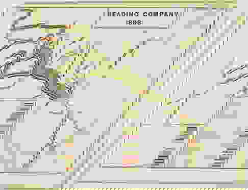
1898 READING RAILROAD MAP
Similar Sale History
View More Items in Maps & Atlases

![Railroad Map of the United States: [America, East Coast] Ensign, Bridgman and Fanning's Railroad Map of the United States showing the Depots & Stations. Engraved map with original hand color. Engraved by W. S. Barnard. New York, 1856.](https://p1.liveauctioneers.com/1968/203922/103366115_1_x.jpg?height=310&quality=70&version=1620913733)
![Railroad Map: Carson & Colorado Proposed 1889 Extension [170579]: Large 22"x 42" hand drawn original map on vellum map of the "Proposed Extension of the Carson & Colorado Railroad from Keeler to Mahave. The scale is four miles to the inch. The map was compiled by L.](https://p1.liveauctioneers.com/2699/299063/159201766_1_x.jpg?height=310&quality=70&version=1692045182)


Related Maps & Atlases


![Pittsburg [Sic] and Vicinity.: Publication Date: 1911 Title: Pittsburg [Sic] and Vicinity. Cartographer: RAND, MCNALLY & CO. Publisher: RAND, MCNALLY & CO. Height: 18.25 Width: 12.3 Map showing western Pennsylvania. Shows railroads](https://p1.liveauctioneers.com/5584/331064/178466317_1_x.jpg?height=310&quality=70&version=1716924723)


More Items in Maps & Atlases
View More![[MAPS]. HOMANN, Johann Baptist, HOMANN HEIRS, and Georg Matthäus SEUTTER. [Composite Atlas].: [MAPS]. HOMANN, Johann Baptist (1663-1724), HOMANN HEIRS, and Georg Matthäus SEUTTER (1678-1757). [Composite Atlas]. [Nuremberg, Augsburg, and others: Homann Heirs and others, maps dated between](https://p1.liveauctioneers.com/197/329395/177650530_1_x.jpg?height=310&quality=70&version=1715364962)
![[MAP]. TODESCHI, Pietro. [Nova et Acurata Totius Americae Tabula auct. G.I. Blaeu] America quarta: [MAP]. TODESCHI, Pietro. [Nova et Acurata Totius Americae Tabula auct. G.I. Blaeu] America quarta pars orbis quam plerunq, nuvum orbem appellitant primo detecta est anno 1492 a Christophoro Columbo...](https://p1.liveauctioneers.com/197/329395/177650542_1_x.jpg?height=310&quality=70&version=1715364962)

![[MAP]. ORTELIUS, Abraham. Americae Sive Novi Orbis, Nova Descriptio. 1573.: [MAP]. ORTELIUS, Abraham (1527-1598). Americae Sive Novi Orbis, Nova Descriptio. Antwerp, 1573. Engraved map with hand-coloring. Framed and double glazed, visible area 375 x 521 mm (unexamined out of](https://p1.liveauctioneers.com/197/329395/177650534_1_x.jpg?height=310&quality=70&version=1715364962)


![Set of Twelve Satirical Anthropomorphic Maps of Europe: [SATIRICAL MAPS] A set of twelve satirical anthropomorphic maps of Europe. London: circa 1868. A set of 12 (believed complete) lithographed maps by Vincent Brooks, Day & Son, London, each offering](https://p1.liveauctioneers.com/292/330597/178279264_1_x.jpg?height=310&quality=70&version=1716409282)


![[MAP]. ORTELIUS, Abraham. Turcici Imperii Descriptio.1592.: [MAP]. ORTELIUS, Abraham (1527-1598). Turcici Imperii Descriptio. Antwerp, 1592. Engraved map with hand-coloring. Matted, framed, and double glazed, sight 406 x 521 mm (unexamined out of frame). Decor](https://p1.liveauctioneers.com/197/329395/177650538_1_x.jpg?height=310&quality=70&version=1715364962)
![[MAP]. ORTELIUS, Abraham. Romani Imperii Imago. 1592.: [MAP]. ORTELIUS, Abraham (1527-1598). Romani Imperii Imago. Antwerp, 1592. Engraved map with hand-coloring. Matted, framed, and double glazed, visible area 381 x 521 mm (unexamined out of frame). 6 de](https://p1.liveauctioneers.com/197/329395/177650537_1_x.jpg?height=310&quality=70&version=1715364962)
![[MAP]. SPEED, John. A New Mappe of the Romane Empire. 1676.: [MAP]. SPEED, John (ca 1551-1629). A New Mappe of the Romane Empire. London: Basset & Chiswell, 1676. Engraved map with hand-coloring. Framed and double glazed, sight 419 x 559 mm. Decorative cartouch](https://p1.liveauctioneers.com/197/329395/177650541_1_x.jpg?height=310&quality=70&version=1715364962)
![[MAP]. ORTELIUS, Abraham. Aevi Veteris, Typus Geographicus. 1601.: [MAP]. ORTELIUS, Abraham (1527-1598). Aevi Veteris, Typus Geographicus. Antwerp, 1601. Engraved map with hand-coloring. Matted, framed, and double glazed, visible area 343 x 470 mm (unexamined out of](https://p1.liveauctioneers.com/197/329395/177650532_1_x.jpg?height=310&quality=70&version=1715364962)

Recommended Transportation & Travel Collectibles
View More


Item Details
Description
A hand-colored disbound railroad map originally from the 'White and Kemble's Atlas and Digest of Railroad Mortgages', 17.5 x 12.5 in., mounted to cardboard, 1898, depicting the railways of the 'Reading Company' spanning Philadelphia through most of Pennsylvania, north into New York, and east to the Jersey Shore. Attached to four additional sheets detailing the company's mortgage information. Moderate toning, stained and chipped, generally worn from age and use.
Buyer's Premium
- 30%
1898 READING RAILROAD MAP
Estimate $100 - $150
2 bidders are watching this item.
Shipping & Pickup Options
Item located in Chesapeake City, MD, usOffers In-House Shipping
Local Pickup Available
Payment

TOP