


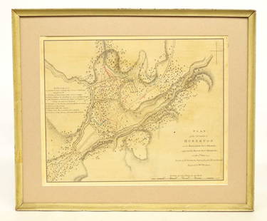
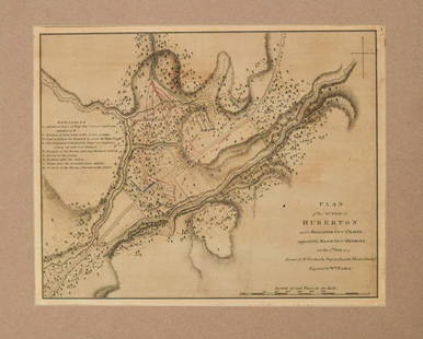
Map of The Battle of Minden - Plan of The Battle of Tonhausen - Germany - Europe
Similar Sale History
View More Items in Maps & Atlases


![1893 Civil War Map of the Battles of Bull Run and Manassas -- Plan of the Battle Field at Bull Run: Title: 1893 Civil War Map of the Battles of Bull Run and Manassas -- Plan of the Battle Field at Bull Run [with] Map of the Battle-Fields of Manassas… [Plate III] Cartographer: US War Department](https://p1.liveauctioneers.com/5584/307299/164242651_1_x.jpg?height=310&quality=70&version=1698786194)

Related Maps & Atlases
![1705 Map LE COMBAT DE STEENKERKE [Battle of Steenkerque] by Nicolas de Fer: 1705 Copperplate Engraved Military Plan / Map Entitled LE COMBAT DE STEENKERKE [Battle of Steenkerque] by Nicolas de Fer - 3 August 1692 (the text gives a date of 5 August 1692) | Approx. Size: 10.5"](https://p1.liveauctioneers.com/6084/330420/178181962_1_x.jpg?height=310&quality=70&version=1716391551)


![[MAP]. ORTELIUS, Abraham. Africae Tabula Nova. 1592.: [MAP]. ORTELIUS, Abraham (1527-1598). Africae Tabula Nova. Antwerp, 1592. Engraved map with hand-coloring. Matted, framed, and double glazed, visible area 406 x 533 mm (unexamined out of frame). Strap](https://p1.liveauctioneers.com/197/329395/177650533_1_x.jpg?height=310&quality=70&version=1715364962)


![1575 Braun and Hogenberg Views of Southern Spain's Vegel and Velis Malaga -- Vegel [on sheet with]: Title: 1575 Braun and Hogenberg Views of Southern Spain's Vegel and Velis Malaga -- Vegel [on sheet with] Velis Malaga Cartographer: Braun and Hogenberg Year / Place: 1575, Augsberg Map Dimension (in.](https://p1.liveauctioneers.com/5584/330117/177981860_1_x.jpg?height=310&quality=70&version=1716324705)

More Items in Maps & Atlases
View More

![[MAP]. TODESCHI, Pietro. [Nova et Acurata Totius Americae Tabula auct. G.I. Blaeu] America quarta: [MAP]. TODESCHI, Pietro. [Nova et Acurata Totius Americae Tabula auct. G.I. Blaeu] America quarta pars orbis quam plerunq, nuvum orbem appellitant primo detecta est anno 1492 a Christophoro Columbo...](https://p1.liveauctioneers.com/197/329395/177650542_1_x.jpg?height=310&quality=70&version=1715364962)


![[MAPS]. HOMANN, Johann Baptist, HOMANN HEIRS, and Georg Matthäus SEUTTER. [Composite Atlas].: [MAPS]. HOMANN, Johann Baptist (1663-1724), HOMANN HEIRS, and Georg Matthäus SEUTTER (1678-1757). [Composite Atlas]. [Nuremberg, Augsburg, and others: Homann Heirs and others, maps dated between](https://p1.liveauctioneers.com/197/329395/177650530_1_x.jpg?height=310&quality=70&version=1715364962)
![[MAP]. ORTELIUS, Abraham. Americae Sive Novi Orbis, Nova Descriptio. 1573.: [MAP]. ORTELIUS, Abraham (1527-1598). Americae Sive Novi Orbis, Nova Descriptio. Antwerp, 1573. Engraved map with hand-coloring. Framed and double glazed, visible area 375 x 521 mm (unexamined out of](https://p1.liveauctioneers.com/197/329395/177650534_1_x.jpg?height=310&quality=70&version=1715364962)


![[MAP]. ORTELIUS, Abraham. Turcici Imperii Descriptio.1592.: [MAP]. ORTELIUS, Abraham (1527-1598). Turcici Imperii Descriptio. Antwerp, 1592. Engraved map with hand-coloring. Matted, framed, and double glazed, sight 406 x 521 mm (unexamined out of frame). Decor](https://p1.liveauctioneers.com/197/329395/177650538_1_x.jpg?height=310&quality=70&version=1715364962)

![[MAP]. ORTELIUS, Abraham. Aevi Veteris, Typus Geographicus. 1601.: [MAP]. ORTELIUS, Abraham (1527-1598). Aevi Veteris, Typus Geographicus. Antwerp, 1601. Engraved map with hand-coloring. Matted, framed, and double glazed, visible area 343 x 470 mm (unexamined out of](https://p1.liveauctioneers.com/197/329395/177650532_1_x.jpg?height=310&quality=70&version=1715364962)

Recommended Transportation & Travel Collectibles
View More


![[FLAGS]. 31-star American parade flag. Ca 1850-1859.: [FLAGS]. 31-star American parade flag. Ca 1850-1859. 22 x 36 1/2 in. cotton flag with 31 printed stars, configured in a double medallion surrounding a much larger central star, that is haloed in both](https://p1.liveauctioneers.com/197/329785/177758218_1_x.jpg?height=310&quality=70&version=1715625218)


Item Details
Description
Plan of the battle of Tonhausen, ye 1st. of August 1759, between his Britannic Majesty's Army, commanded by Prince Ferdinand of Brunswick, and that of France by Marshal De Contades: With the different Motions of the two Armies from the 14th. of July to the 1st. of August 1759. A plan of the Battle of Tonhausen/Minden detailing, along with the explanatory legend on page 169, detailing movements and positions around the time of Britain's famous and incredible victory. As a battle plan, land cover is highly detailed while cities (including the fortified Minden) are quite generalized; relief, terrain, and waterways are all shown as they all had direct bearing on the battle and pertain directly to what the reader would wish to see of the engagement. An elaborate cartouche frames the work's title and includes cattails and bullrushes along the scroll motif.
Buyer's Premium
- 23%
Map of The Battle of Minden - Plan of The Battle of Tonhausen - Germany - Europe
Estimate €350 - €450
1 bidder is watching this item.
Get approved to bid.
Shipping & Pickup Options
Item located in Bromma, Stockholm County, seOffers In-House Shipping
Payment

TOP