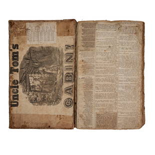
Circa 1815 Engraved Map A Plan of the Grand of the New Townships on the Grand or Ottawa River
Similar Sale History
View More Items in Books

Related Books
More Items in Books
View MoreRecommended Books, Magazines & Papers
View More


Item Details
Description
Circa 1815 A Plan of the Grand of the New Townships on the Grand or Ottawa River. London 1815. Engraved map by J. Walker. From Joseph Bouchette's book. "Joseph Bouchette's books played an important part in the geography and topography of Canada. Some of them were illustrated by himself and he was a noted cartographer" Spendlove p86. Rare find and nicely framed. Map measures 24"W x 8"H. Frame measures 32" x 16 1/2".
Buyer's Premium
- 25% up to $50,000.00
- 20% up to $100,000.00
- 15% above $100,000.00
Circa 1815 Engraved Map A Plan of the Grand of the New Townships on the Grand or Ottawa River
Estimate $400 - $500
7 bidders are watching this item.
Shipping & Pickup Options
Item located in Vancouver, BC, caSee Policy for Shipping
Local Pickup Available
Payment

Related Searches
TOP


![MITCHELL - New General Atlas [35 American maps] 1867: MITCHELL, S. Augustus, Jr.. Mitchell's New General Atlas, containing maps of various countries of the world, plans of cities, etc., ... together with valuable statistical tables. Philadelphia: S. Augu](https://p1.liveauctioneers.com/7533/208644/106251073_1_x.jpg?height=310&quality=70&version=1624641782)


![1715, King James Bible, Folio, Large Pulpit Size: 1715, FOLIO KING JAMES BIBLE VERSION WITH GENEVA NOTES 16" x 10". [28], 712, [2], 160, 248 pp. (text complete), + 2 (of 6) double-page maps/plans by Moxon Including plan of Jerusalem and map of Cana](https://p1.liveauctioneers.com/6752/145177/73447828_1_x.jpg?height=310&quality=70&version=1562055217)


![1744 ROMAN HISTORY ARMORIAL VELLUM BINDING antique w/ MAP by LUCIUS FLORUS: Lucius Annaeus Florus Epitome Rerum Romanarum Ed. C.A. Duker. Leyden, S. Luchtmans, 1744 2 parts in 1 vol. (58),858[= 874],(120),39[= 47],(1)p. Engraved frontispiece, folding map Original vellum, scho](https://p1.liveauctioneers.com/5584/292108/154819414_1_x.jpg?height=310&quality=70&version=1686690530)


![19 issues of rare Gay Magazine METRA 1985-1986: [Queer interest], Metra: Midwest America's Leading Free Gay Magazine, 19 issues, published 1986-1987, a few duplicates, softcover, staplebound wraps, illustrated throughout in black and white, publish](https://p1.liveauctioneers.com/184/328649/177016396_1_x.jpg?height=310&quality=70&version=1714770323)


