


Map Provinces of Canada 1862 Johnston
Similar Sale History
View More Items in Maps & Atlases![Keith Johnston Map [Map of Canada]: Keith Johnston (cartographer) map of Canada in two sheets, Western Sheet and Eastern Sheet. Title 'Province of Canada'. Circa 1862. Each sheet measures 19.375-in. x 24.5-in. sheet size. Gold-gilt edge](https://p1.liveauctioneers.com/5755/147592/74586284_1_x.jpg?height=310&quality=70&version=1565735214)


Related Maps & Atlases


![Cartagène, Ste. Marthe et Venezuela'. Colombia. Cartagena. BELLIN 1754 map: CAPTION PRINTED BELOW PICTURE: Carte des Provinces de Cartagène, Ste. Marthe et Venezuela [Map of Provinces of Cartagena, Santa Marta and Venezuela] DATE PRINTED: 1754 IMAGE SIZE: Approx 20.5 x 3](https://p1.liveauctioneers.com/5584/330116/177980520_1_x.jpg?height=310&quality=70&version=1716324705)

![d'Anville (Jean Baptiste Bourguignon) [Untitled Composite Atlas with 102 map sheets], [probably: d'Anville (Jean Baptiste Bourguignon) [Untitled Composite Atlas with 102 map sheets], comprising 20 double-page maps, 9 two-sheet double-page maps, 3 two-sheet maps on folding double-pages [Asia, Afri](https://p1.liveauctioneers.com/5458/329231/177514974_1_x.jpg?height=310&quality=70&version=1715269091)


More Items in Maps & Atlases
View More

![[MAP]. TODESCHI, Pietro. [Nova et Acurata Totius Americae Tabula auct. G.I. Blaeu] America quarta: [MAP]. TODESCHI, Pietro. [Nova et Acurata Totius Americae Tabula auct. G.I. Blaeu] America quarta pars orbis quam plerunq, nuvum orbem appellitant primo detecta est anno 1492 a Christophoro Columbo...](https://p1.liveauctioneers.com/197/329395/177650542_1_x.jpg?height=310&quality=70&version=1715364962)


![[MAPS]. HOMANN, Johann Baptist, HOMANN HEIRS, and Georg Matthäus SEUTTER. [Composite Atlas].: [MAPS]. HOMANN, Johann Baptist (1663-1724), HOMANN HEIRS, and Georg Matthäus SEUTTER (1678-1757). [Composite Atlas]. [Nuremberg, Augsburg, and others: Homann Heirs and others, maps dated between](https://p1.liveauctioneers.com/197/329395/177650530_1_x.jpg?height=310&quality=70&version=1715364962)


![[MAP]. ORTELIUS, Abraham. Turcici Imperii Descriptio.1592.: [MAP]. ORTELIUS, Abraham (1527-1598). Turcici Imperii Descriptio. Antwerp, 1592. Engraved map with hand-coloring. Matted, framed, and double glazed, sight 406 x 521 mm (unexamined out of frame). Decor](https://p1.liveauctioneers.com/197/329395/177650538_1_x.jpg?height=310&quality=70&version=1715364962)
![[MAP]. ORTELIUS, Abraham. Americae Sive Novi Orbis, Nova Descriptio. 1573.: [MAP]. ORTELIUS, Abraham (1527-1598). Americae Sive Novi Orbis, Nova Descriptio. Antwerp, 1573. Engraved map with hand-coloring. Framed and double glazed, visible area 375 x 521 mm (unexamined out of](https://p1.liveauctioneers.com/197/329395/177650534_1_x.jpg?height=310&quality=70&version=1715364962)

Recommended Transportation & Travel Collectibles
View More


Item Details
Description
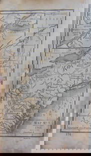
PROVINCE OF CANADA
Nice coloured map of Provinces of Canada (British colony Wellington, Lake Huron, Georgian Bay, Victoria of 1862 circa.
Author: W. & A. K. Johnston
Date: 1862 circa
Technique: Copper etching
Leaf Dimension: 49,5x62 cm (19.5x24.4 inches)
Engraving Dimension: 44x57,5 cm (17.3x22.6 inches)
Conditions: Good conditions. Little tears in the foot edge. Vertical folding of the page.
Economy shipping: USA Canada and the rest of the world $7.50 (10-15 working days), UE $9 (5-8 working days).
Buyer's Premium
- 0%
Map Provinces of Canada 1862 Johnston
Estimate $100 - $150
5 bidders are watching this item.
Shipping & Pickup Options
Item located in Foligno (PG), PG, itSee Policy for Shipping
Payment

Related Searches
TOP