


1752 Map of Indoustan India Bengal Kashmir
Similar Sale History
View More Items in Maps & Atlases


Related Maps & Atlases


![1898 Rand McNally Map of Texas [verso] Indian Territory and Oklahoma -- Texas [verso] Oklahoma and: Title: 1898 Rand McNally Map of Texas [verso] Indian Territory and Oklahoma -- Texas [verso] Oklahoma and Indian Territory Cartographer: Rand McNally Year / Place: 1898, Chicago Map Dimension (in.): 9](https://p1.liveauctioneers.com/5584/328338/176911581_1_x.jpg?height=310&quality=70&version=1715113718)
![1887 Cram Map of Texas [verso] Indian Territory [verso] Arkansas -- Texas [verso] Indian Ty. [verso]: Title: 1887 Cram Map of Texas [verso] Indian Territory [verso] Arkansas -- Texas [verso] Indian Ty. [verso] Arkansas Cartographer: G Cram Year / Place: 1887, Chicago Map Dimension (in.): 11.8 X 17 in.](https://p1.liveauctioneers.com/5584/328338/176911685_1_x.jpg?height=310&quality=70&version=1715113718)


![1894 Johnston Map of Oceania [verso] Island in the Indian Ocean and Near Africa -- Oceania [verso]: Title: 1894 Johnston Map of Oceania [verso] Island in the Indian Ocean and Near Africa -- Oceania [verso] Madagascar; Mauritius; Seychelles; Cape Town; St. Helena and Ascension Islands; Socotra; Aden](https://p1.liveauctioneers.com/5584/328338/176911535_1_x.jpg?height=310&quality=70&version=1715113718)


More Items in Maps & Atlases
View More

![[Maps] Gio. Ant. Magnini, Italia, 1620: [Maps] Gio. Ant. Magnini, Italia, 1620, Giovanni Antonio Magnini. Italia, data in luce da Fabio suo figliuolo al Serenissimo Ferdinado Gonzaga Duca di Matoua edi Monserrato etc. Bologna, for Sebastian](https://p1.liveauctioneers.com/188/326797/176317457_1_x.jpg?height=310&quality=70&version=1713847031)
![[Maps] Martin Zeiler, Itinerarium Italiae, 1640: [Maps] Martin Zeiler, Itinerarium Italiae, 1640, Martini Zeilleri. Itinerarium Italiae Nov-Antiquae: oder, Raiss-Beschreibung durch Italien, Matthaus Merian, Frankfurt, 40 plates, most double-page, in](https://p1.liveauctioneers.com/188/326797/176317459_1_x.jpg?height=310&quality=70&version=1713847031)


Recommended Transportation & Travel Collectibles
View More


Item Details
Description
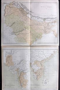
A map of Jacques Bellin showing a portion of India, "Carte de L'Indoustan", printed at Paris circa 1752, shows portion including Kashmir and Bengal. Fine folding, measures 15 x 10".
Reserve: $100.00
Shipping:Domestic: Flat-rate of $8.00 to anywhere within the contiguous U.S. International: Foreign shipping rates are determined by destination. Combined shipping: Please ask about combined shipping for multiple lots before bidding. Location: This item ships from Florida
Your purchase is protected:
Photos, descriptions, and estimates were prepared with the utmost care by a fully certified expert and appraiser. All items in this sale are guaranteed authentic.
In the rare event that the item did not conform to the lot description in the sale, Jasper52 specialists are here to help. Buyers may return the item for a full refund provided you notify Jasper52 within 5 days of receiving the item.
Reserve: $100.00
Shipping:
Your purchase is protected:
Photos, descriptions, and estimates were prepared with the utmost care by a fully certified expert and appraiser. All items in this sale are guaranteed authentic.
In the rare event that the item did not conform to the lot description in the sale, Jasper52 specialists are here to help. Buyers may return the item for a full refund provided you notify Jasper52 within 5 days of receiving the item.
Condition
Fine
Buyer's Premium
- 15%
1752 Map of Indoustan India Bengal Kashmir
Estimate $120 - $150
2 bidders are watching this item.
Shipping & Pickup Options
Item located in Florida, US$8 shipping in the US
Payment
See More Items From This Jasper52 Seller

Related Searches
TOP