Sold2023Antique Framed Wayfarer's Map of New York 1939Antique Framed Wayfarer's Map of New York 1939. Framed. Signed by Charles D. Graves, possibly the map maker. Copyrighted 1939, Herbert C. Wyman, Pleasantville, NY. Wayfarer's Maps.See Sold Price
Sold2021Antique Framed Map of Columbia County, NY 1829Antique Framed Map of Columbia County, NY, dated 1829. Engraved by Rawdon Clark & Co, Albany, NY. Also marked Rawdon Wright, New York. Map includes locations of mills, churches and stage roads. NicelySee Sold Price
Sold2022Antique NEW YORK CITY MAP - FramedAntique New York City Map. 28” x 16” New York City map, circa 1860, hand-colored, double matted and framed to 38 ½” x 26”.See Sold Price
Sold2023Framed Antique Agricultural Map Of NY State, 1843Marked on lower left corner reads Agricultural map of the state of New York. Lith of G & W endicott New York, Map is colored in correspondence with the color of agriculture throughout the state. FrameSee Sold Price
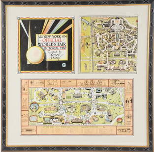
Sold2022Framed Tony Sarg 1939 World's Fair Pictorial MapTony Sarg (American, 1880-1942), "The New York 1939 Official World's Fair Pictorial Map Created by Tony Sarg 25¢" cover and Transportation Zone maps, three pieces matted and under glass in paintedSee Sold Price
Sold20241866 FRAMED MAP OF PRUSSIA GERMANYJOHNSON'S NEW YORK, HAND COLORED MAP, DATED 1866. LOOSE IN FRAME. 26" X 32" IN FRAMESee Sold Price
Sold2018Mitchell: Antique Map of New York State w/ city insetsCounty Map of the State of New York The beautifully detailed and colored county map of New York State from the 1870 edition of Mitchell's popular New General Atlas of the world. Framed by the vine motSee Sold Price
Sold2021Four Antique Hand Colored MapsA grouping of four small framed hand-colored engraved maps to include New England and New York by John Seller, A Mapp of the World by John Seller, Terra Firma, and Moscovia (Moscow) of Russia. All inSee Sold Price
Sold2023A Decorative Pictorial Map of The New York Worlds Fair by William L. Longyear (American, 1899-1980)A Decorative Pictorial Map of The New York Worlds Fair by William L. Longyear (American, 1899-1980). Framed. Designed and copyrighted by William Longyear. Lithographed in U.S.A by Polygraphic CompanySee Sold Price
Sold2023New York World's Fair 1939 Poster by John Atherton (American, 1900-1952)New York World's Fair 1939 Poster by John Atherton (American, 1900-1952). Framed. Marked Atherton under the '1' of 1939. Photomechanical lithograph.See Sold Price
Sold2023New York World's Fair 1939 Poster by Albert Staehle (German ,1899-1974)New York World's Fair 1939 Poster by Albert Staehle (German ,1899-1974). Framed. Printed by Grinnell, New York. Offset lithograph.See Sold Price
Sold2024Antique 1883 Eldridge's Chart Long Island SoundAntique 1883 Eldridge's Chart Long Island Sound From Newport to New York by Geo. Eldridge, Hydrographer and Published by S. Thaxter & Son. The map is framed in a metal map frame with no glass. The mapSee Sold Price
Sold20234 Alphonse Mucha Book Plate Lithographs Clio Anatole FranceAlphonse Maria Mucha (New York, France, Czech Republic1860 - 1939) Book Plate Prints from the Clio Illustrations. Lot consists of three plates and the Clio cover. All are framed in simple gold framingSee Sold Price
Sold2018LARGE ANTIQUE HAND COLORED MAP JEFFERSON COUNTY NYLarge antique hand colored map of Jefferson County, New York. Circa 1855. Framed in large wooden frame and laid down to canvas backing. Condition: mounted/laid on canvas for preservation, some areas rSee Sold Price
Sold20231732 H. Moll New England New York, NJ. & PA Map1732 H. Moll New England New York, New Jersey, and Pennsylvania with hand coloring. Framed, 8 by 11 1/2 in acid free matt. Beautiful Map.See Sold Price
Sold202118TH C. (1755) MAP OF N.Y. , PENSYLVANIA & NEW ENGLANDFRAMED 18TH C. (DATED 1755) 2 PART MAP "A MAP OF THE PROVINCE OF NEW YORK, WITH PART OF PENSILVANIA AND NEW ENGLAND / FROM AN ACTUAL SURVEY BY CAPTAIN MONTRESOR, ENGINEER 1755" - FRAME 59 1/4" X 39",See Sold Price
Sold2024ANTIQUE ENGLSIH OIL PAINTING RICHARD SAMUEL SIDAYRichard Samuel Siday, English, British, American, 1854 to 1939, an antique oil painting on canvas, New York Harbor in Moonlight, 1885. Signed and dated, lower left. Framed. Richard Samuel Siday was aSee Sold Price
Sold20231778 J. Lodge Exact Map of the Five Great Lakes1778 Lodge Exact Map of the Five Great Lakes with Part of Pensilvania New York, Canada and Hudson's Bay Territories from the best Surveys. Hand colored, fine framed acid free mount example. 8 1/2 by 1See Sold Price
Sold2022Antique French Map of AfricaAntique French Map of Africa. "Carte de L'Afrique..."by J. Andriveau-Goujon, Paris, dated 1841. Framed. Ex. Collection William and Diane Bousquette, Purchase, New York. Size: 15'' x 19.5'', 38 x 50 cmSee Sold Price
Sold2016(2) ANTIQUE IRELAND MAPSCarte D' Irlande map published in 1867 by Alvin J. Johnson New York. Measures 10 3/4" x 15 3/4" (Framed 19 1/2" x 23 1/2") and a Jacques Nicolas Bellin A Chart of Ireland 1803 hand colored map. MeasurSee Sold Price
Sold2022[ANTIQUE MAPS] OGILBY--YORK TO WHITBY, SCARBORO 1675[ANTIQUE MAPS] OGILBY, John "YORK TO WHITBY, SCARBORO" London, UK 1675. 50X36cm. Scrolled road map. Framed. Hand-coloured. The complete route, with a spur from New Malton to Scarborough. Frame not incSee Sold Price
Sold2017Antique Map: New York & Area - EngravingPensylvania Nova Jersey et Nova York cum Regionibus Ad Fluvium Delaware In America Sitis, Nova Delinatione ob oculos posita...Tobias Conrad Lotter (1717 - 1777). Engraved map with hand-color in part.See Sold Price
Sold2016Antique Map : New York, New Jersey - 1870Antique Map : New York, New Jersey, Pennsylvania, Ohio, Delaware, Maryland , Virginia & West Virginia - 1870 Size : 15.5" x 18.5"See Sold Price
Sold2021Lot Antique Maps New York New JerseyLot of Antique Maps Of New York, New Jersey & Massachusetts. Includes 11 maps from 19th century. Largest map measures 20 inches in height by 23 inches in width. This sale is online only - no public prSee Sold Price
5 days LeftEldred'sCOLOR LITHOGRAPH "COFFEE MAP OF THE REPUBLIC OF COLOMBIA" New York, 1939 32" x 27". Framed.$50
7 days LeftKotler Galleries & Auctioneers3 WILLIAM GROPPER LITHOGRAPHS; ATTORNEY, SUMMATION, LAWYER, LEGAL Litho 3 William Gropper$1,000
Jun 23Curated Gallery AuctionsVintage American Modernist Abstract Pop Art Signed Still Life Framed New York School Oil Painting$10
Jun 23Curated Gallery AuctionsVintage Pop Art Charles Fazzino 3-d Signed Original Limited Edition Framed New York Print$10
Featured2024Jasper52NEW YORK CITY antique town city map plan. Manhattan Brooklyn Jersey. SDUK 1844See Sold Price
5 days LeftEldred'sFREDERICK TORDOFF (New Jersey/New York, 1939-), "Naval Engagement"., Oil on panel, 12" x 17". Framed$100
2024Jasper52A Topographical Map of the northn. part of New York Island… FADEN/STEDMAN 1794See Sold Price
2024Jasper52An accurate Map of New York, in North America… Universal Magazine 1780 oldSee Sold Price
Featured2024Jasper52A plan of the operations of the King's army… in New York… FADEN/STEDMAN 1794 mapSee Sold Price
Jun 23Curated Gallery AuctionsBeatrice Lewis Signed Vintage Pink Glowing Sunset New York Cityscape Framed Oil Painting$30(3 bids)
Jul 11Eldred'sCOULTON WAUGH (New York, 1896-1973), "The Map of Old Cape Cod"., 19.5" x 27.5" sight. Framed 21" x$125


![[ANTIQUE MAPS] OGILBY--YORK TO WHITBY, SCARBORO 1675: [ANTIQUE MAPS] OGILBY, John "YORK TO WHITBY, SCARBORO" London, UK 1675. 50X36cm. Scrolled road map. Framed. Hand-coloured. The complete route, with a spur from New Malton to Scarborough. Frame not inc](https://p1.liveauctioneers.com/8321/253807/131946541_1_x.jpg?height=310&quality=70&version=1657215628)


