Sold20241696 Jaillot Mapping The Ottoman Empire at the End of the 17th Centuryoverview of the Turkish Empire at the close of the 17th century. The map is centered on Asia Minor, but extends west to Spain and the Kingdom of Algiers and east to the Caspian Sea and the Arabian PenSee Sold Price
Sold201717th C. Indian Mughal Painting - Shah Jahan and MumtazCentral Asia, India, Mughal Empire, ca. 17th to 18th century CE. A gorgeous, bright painting depicting the Mughal emperor Shah Jahan and his beloved wife Mumtaz Mahal, whose death inspired her husbandSee Sold Price
Sold201719th C. Mughal Painting of Princess, ex-ButterfieldsSouth Asia, India, Mughal Empire, ca. 19th Century CE. A finely painted depiction of an attractive Mughal princess against a sky blue background. The artist presents the fair lady in a diaphanous silkSee Sold Price
Sold2024Indian Mughal Sandstone Relief Panel, Foliate MotifSouth Asia, India, Mughal Empire, ca. 17th to 19th century CE. A beautiful sandstone relief panel, hand-carved with abstract scrolling, foliate motifs surrounded by a latticework border. Half of a lotSee Sold Price
Sold202319th C. Mughal Reverse Glass Painting - Seated Prince**Originally Listed At $1350** South Asia, India, Mughal Empire , ca. 19th Century CE. A large reverse glass painting of a Mughal prince sitting in an elegant chair while contemplating the beauty of aSee Sold Price
2017Mughal 18K Gold Pendant w/ Ruby, Diamond & EmeraldCentral Asia, India, Mughal Empire, ca. 17th to 18th century CE. A gorgeous 18 karat gold pendant studded with diamonds (six), rubies (seventeen), and an emerald (one). It is in two parts, joined by aSee Sold Price
Sold2021Beautiful 19th C. Mughal Floral Brooch w/ White TopazCentral Asia, India, Mughal Empire, ca. early to mid-19th century CE. An enticing brooch of an elegant floral form that is shaped from brass with 67 petite bezels, each holding a faceted white topaz sSee Sold Price
Sold2021Elegant 19th C. Mughal Floral Brooch w/ White TopazCentral Asia, India, Mughal Empire, ca. early to mid-19th century CE. A gorgeous and dignified brooch of a tall, tapered form with an intricate body made from 5 brass components attached to a centralSee Sold Price
Sold202119th C. Mughal Gold Pendant- White Topaz, Glass, RubiesSouth Asia, Northwestern India, Mughal Empire, ca. 19th century CE. This is a stunning Mughal pendant made of high-quality gold inlaid with green glass and Kundan stones of white topaz and rubies! TheSee Sold Price
Sold202219th C. Indian Mughal Gold Pendant - Topaz, RubiesSouth Asia, Northwestern India, Mughal Empire, ca. 19th century CE. This is a stunning Mughal pendant made of high-quality gold inlaid with green glass and Kundan stones of white topaz and rubies! TheSee Sold Price
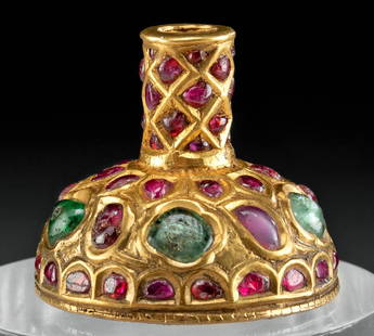
Sold2023Indian Mughal Gold Hair Ornament w/ Rubies, EmeraldsSouth Asia, Northwestern India, Mughal Empire, ca. 19th century CE. A stunning bell-shaped hair ornament made of high-quality gold that is filled with lac resin and inlaid with polki cut green emeraldSee Sold Price
Sold202319th C. Indian Mughal Gold & Diamond Armband Pendant**First Time At Auction** South Asia, Northwestern India, Mughal Empire, ca. 19th century CE. This is a stunning gold and polki diamond Mughal bazuband pendant, worn around the outside of the upper arSee Sold Price
Sold20201734 ATLAS Vaugondy MAPS Geography Asia Africa Europe1734 ATLAS Vaugondy MAPS Geography Asia Africa Europe USA France Germany Collectors, of both maps and atlases, agree that Vaugondy maps are among the best and most accurate maps! The collection of 18tSee Sold Price
Sold2024Indian Mughal Jade Holdali Pendant w/ Diamonds, GemsSouth Asia, Northern India, Rajasthan, Mughal Empire ca. 19th century CE. A spectacular jade Holdali pendant, the frontal face is inlaid with precious gemstones within high quality gold embellishmentsSee Sold Price
Sold2022MITCHELL, SAMUEL AUGUSTUS. A New Universal Atlas Containing Maps of the Various Empires, Kingdoms,MITCHELL, SAMUEL AUGUSTUS. A New Universal Atlas Containing Maps of the Various Empires, Kingdoms, States and Republics of the World; With a Special Map of Each of the United States, Plans of Cities,See Sold Price
Sold2017Mitchell's 1849 New Universal AtlasHeading: Author: Mitchell, S. Augustus Title: New Universal Atlas Containing Maps of the various Empires, Kingdoms, States and Republics of the World. With a special map of each of the United States,See Sold Price
Sold2016Mitchell's New Universal Atlas 1847Heading: Author: Mitchell, S. Augustus Title: A New Universal Atlas Containing Maps of the Various Empires, Kingdoms, States and Republics of the World with a Special Map of each of the United StatesSee Sold Price
Sold2018MITCHELL, Samuel Augustus (1790-1868).* MITCHELL, Samuel Augustus (1790-1868). A New Universal Atlas Containing Maps of the Various Empires, Kingdoms, States, and Republics of the World, with a Special Map of Each of the United States, PlSee Sold Price
Sold2022MITCHELL'S UNIVERSAL ATLASNew Universal Atlas Containing Maps of the various Empires, Kingdoms, States, and Republics of the World, S. Augustus Mitchell, Philadelphia, 1847; Condition: boards detached; 17 1/4 x 14 inchesSee Sold Price
Sold20241784 Herman Moll "Bowles's Geographica Classica or the Geography of the Ancients"as contained in the greek and latin classics, exhibited in 32 maps showing the several empires, kingdoms, and provinces, the chief cities, towns, rivers and mountains mentioned in Homer, Herodotus, JuSee Sold Price
Sold20181780 VOYAGES 17 ATLAS Maps Geography Asia Africa Europe1780 VOYAGES 17 ATLAS Maps Geography Asia Africa Europe USA Vaugondy Collectors, of both maps and atlases, agree that Vaugondy maps are among the very best and most accurate maps! This collection of 1See Sold Price
Sold2022SMITH, CHARLES Smith's New General Atlas Containing District Maps of All the Principal Empires,SMITH, CHARLES Smith's New General Atlas Containing District Maps of All the Principal Empires, Kingdoms & States throughout the World. London: C. Smith, 1809. Old calf-backed boards. 15 3/4 x 12 5/8See Sold Price
Sold20231781 ATLAS Vaugondy 17 MAPS FAMOUS Voyages Geography Asia Africa Europe French1781 ATLAS Vaugondy 17 MAPS FAMOUS Voyages Geography Asia Africa Europe French Collectors, of both maps and atlases, agree that Vaugondy maps are among the best and most accurate maps! This collectionSee Sold Price
Sold2021Asia According to the Sieur DPublication Date: 1772 Title: Asia According to the Sieur D'anville, Cartographer: ANVILLE, J.B.B. D' Publisher: SAYER, ROBERT Height: 20.3 Width: 47 "Divided into Empires, Kingdoms, and States, showiSee Sold Price
5 days LeftJasper521796 VOYAGES of CAPTAIN COOK 3 vols 1st US EDITION ILLUSTRATED antique ENGLISH$1,000
5 days LeftJasper521869 Mitchell Map of South-Central Europe [verso] Asia -- XXXIV Austria, Switzerland, Italy, Turkey$30
5 days LeftJasper521896 STANFORD'S COMPEDIUM of GEOGRAPHY & TRAVEL ASIA 2 VOLS. antique ILLUSTRATED$220
5 days LeftJasper521906 HISTORY of JAPAN & KINGDOM of SIAM Thailand 3 VOLUMES antique ILLUSTRATED$200
774 Lots AwayKey Date Coins336-323 BC Ancient Greek Coin Macedonia Alexander The Great AE 17mm Grades vf$50
918 Lots AwayKey Date Coins330 - 323 BC Ancient Greece Alexandder the Great Amphipolis Mint Ancient Grades f$130
635 Lots AwayKey Date Coins336-323 BC Ancient Greek Coin Macedonia Alexander The Great AE 18mm 4.6g Sear 6739v Grades vf$50
782 Lots AwayRapid Estate Liquidators and Auction GalleryCrown Prince of Prussia Friedrich Wilhelm Autographed Card$350


![1869 Mitchell Map of South-Central Europe [verso] Asia -- XXXIV Austria, Switzerland, Italy, Turkey (1 of 2)](https://p1.liveauctioneers.com/5584/328338/176911683_1_x.jpg?height=282&quality=70&version=1715113718)


