Sold2020Large Pacific Islands Tapa Cloth, ca. 1970**First Time At Auction** Pacific Islands, Fiji, Samoa, Hawaii, Tonga, the Cook Islands, or Papua New Guinea, ca. 1970 CE. A stunning tapa cloth presenting multiple bands of stylized geometric motifsSee Sold Price
Sold2021[Pacific Islands] Oceanic Steamship Co. Playing Cards.[Pacific Islands] Oceanic Steamship Co. Playing Cards. San Francisco, ca. 1920. 52 + J + EC + OB. Joker advertises the ocean liner’s service to Hawaii, Samoa, Tahiti, New Zealand, Australia, andSee Sold Price
Sold2020PACIFIC ISLANDS Polynesia Tahiti Hawaii Samoa FijiTITLE/CONTENT OF MAP: 'POLYNESIA, OR ISLANDS IN THE PACIFIC.Mariana or Ladrones, Pelew Islands. or Palaos, Gilbert Islands. or Scarborough Range, Marshall Islands, Otdia or Romanzoff Group, GalapagosSee Sold Price
Sold2020Bartholomew, John 1922 Pair Maps. New Zealand & Pacific"New Zealand" and "Islands of Oceania" The latter showing Hawaii and other Pacific Islands. Large Lithograph Maps Published 1922 by The Times, London for "The Times Survey Atlas of the World" Maps bySee Sold Price
Sold2024James Cook - Map of Tahiti, the Society Islands, and the VicinityEngraved nautical map from the 1774 first French edition of the first map of New Zealand, illustrating Lieutenant James Cook's 1769 exploration of the passage between New Zealand's North and South islSee Sold Price
Sold2024James Cook - Map / Chart Of The Island TahitiEngraved nautical map from the 1774 first French edition of the first map of New Zealand, illustrating Lieutenant James Cook's 1769 exploration of the passage between New Zealand's North and South islSee Sold Price
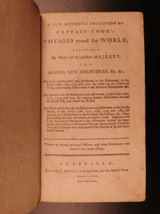
Sold20191786 VERY RARE Voyages of Captain James Cook Hawaii1786 VERY RARE Voyages of Captain James Cook Hawaii Pacific Australia New Zealand “Remember, the greater the opportunity, the fewer are those who see it.” – James Cook James Cook was an 18th-cenSee Sold Price
Sold2020Arts and Crafts of the Cook IslandsArts and Crafts of the Cook Islands Te Rangi Hiroa (Buck, Peter H. ) Honolulu, Hawaii: Bernice P. Bishop Museum (1944). English Text/Edition 550 pages 291 illustrations Softcover 25,8 x 17,5 x 4,2 cm.See Sold Price
Sold2016Town of Southampton Map (North Haven & Art Village),Original engraving of Southhampton town, including Peconic Bay, Hobson Island and many landmarks & family names. Published by E. Belcher Hyde from "Atlas of Suffolk County, Long Island, New York," 190See Sold Price
Sold2022MACLEOD, Alexander Samuel (1888-1956). A Map of Honolulu an...MACLEOD, Alexander Samuel (1888-1956). A Map of Honolulu and the Sandwich Islands which we now call the Hawaiian Islands. 1927. New York: Henry M. Snyder. Scarce and detailed map of Honolulu, with anSee Sold Price
Sold2022Jacob Monk Wall Map of North America 1860Monk's Standard American Map exhibiting the larger portion of North America Embracing The United States and Territories, Mexico, Central America, including the West India Islands, Canada, New BrunswicSee Sold Price
Sold2020Late 19th C. Hawaiian Milo Wood Bowl**First Time At Auction** New World, Hawaiian Islands, ca. 1880s. A beautiful bowl skillfully carved from milo wood, a species native to Hawaii, with its exterior and interior polished to a high sheenSee Sold Price
Sold2020New and Complete Map of Scotland, And Islands TheretoTitle/Content of Map: New and Complete Map of Scotland, And Islands Thereto Belonging; Cartographer: Date: 1779 Publisher: ROBT. SAYER Size: 46.7Height - 39.7Width "from actual surveys, the Shires proSee Sold Price
Sold2021[HAWAII] Dole Pictorial Map of the Hawaiian Islands.[HAWAII] Dole Pictorial Map of the Hawaiian Islands. 1937. Offset lithograph. Scarce pre-war pictorial map of the islands, filled with vignettes of the natural and man-made landmarks, modes of transpoSee Sold Price
Sold2022Evans, Lewis A General Map of the Middle British Colonies in AmericaEvans, Lewis A General Map of the Middle British Colonies in America viz. Virginia, Maryland, Delaware, Pensilvania, New-Jersey, New York, Connecticut and Rhode Island: of Aquanishuonigy the Country oSee Sold Price
Sold202334 Civil War Related Papers and PhotosA fine collection of Civil War documents from 1861 - 1922. Highlighting the collection is a manuscript map in a contemporary hand showing a "Map of the route marched by 5th Regt P.R.v.C.(?) Starts inSee Sold Price
Sold20211721 Map of America With California as an IslandHistoric Maps 1721 Hand-Colored "A New Map of America from the Latest Observations" with "California" Shown as an Island 1721 Hand-Colored Engraved Western Hemisphere Map titled, "A New Map of AmericaSee Sold Price
Sold2022Christo and Jeanne-Claude SURROUNDED ISLANDS PROJECT FOR BISCAYNE BAY, GREATER MIAMI, FLORIDA MixedChristo and Jeanne-Claude (1935-2020 and 1935-2009) SURROUNDED ISLANDS PROJECT FOR BISCAYNE BAY, GREATER MIAMI, FLORIDA (SCHELLMANN 132) Color screenprint, photograph, collotype and collage of map, maSee Sold Price
Sold2022JEFFERYS, THOMAS The Coast of West Florida and Louisiana/ The Peninsula and Gulf of Florida orJEFFERYS, THOMAS The Coast of West Florida and Louisiana/ The Peninsula and Gulf of Florida or Channel of Bahama with the Bahama Islands. London: Robert Sayer, 20 February 1775. Engraved map on joinedSee Sold Price
Sold2024Pownall Map of North America with the West India IslandsPOWNALL, Thomas (1720-1805). A New Map of North America with the West India Islands, divided according to the Preliminary Articles of Peace, Signed at Versailles, 20, jan 1783, wherein are particularlSee Sold Price
Sold2022Munson's A New Map of the Western Rivers, 1846MUNSON, Sam[ue]l B[ishop] (1806-1880). A New Map of the Western Rivers. Or Travellers Guide Exhibiting the Mississippi, Missouri, Ohio, and Illinois Rivers, with all the Principal Towns, Islands & DisSee Sold Price
Sold20151867 Map of California and NevadaLeander Ransom & Amos Doolittle: A New Map of the States of California and Nevada, Exhibiting the Rivers, Lakes, Bays and Islands, with the principal Towns, Roads, Railroads and Transit Routes to theSee Sold Price
Sold2024POWNALL, Thomas (1777-1805). A New and Correct Map of North America, with the West India Islands,POWNALL, Thomas (1777-1805). A New and Correct Map of North America, with the West India Islands, Divided according to the last Treaty of Peace, Concluded at Paris, 10th Feby. 1763, wherein are particSee Sold Price
Sold2023Rare 1721 John Senex "A New Map Of The World"DESCRIPTION: Rare antique engraved map by John Senex entitled "A New Map of the World" depicting California as an island and with parts of the world still unmapped. Further featuring hand coloring, foSee Sold Price
Jun 23Schilb Antiquarian Rare Books1786 Voyages James Cook New Zealand Tahiti Palestine Palmyra Temple SYRIA 4v$2(2 bids)
Jun 02Schilb Antiquarian Rare Books1880 Captain James Cook Voyages Hawaii Pacific Australia Kippis South Sea Navy$50(3 bids)
Jun 06Freeman's | HindmanSTEVENSON, Robert Louis (1850-1894). Treasure Island. London, Paris & New York: Cassell & Company,$1,500
Jun 06Freeman's | HindmanWELLS, H.G. (1866-1946). A group of 9 FIRST EDITIONS, comprising:$225(2 bids)
Featured2 days LeftJasper521867 Beers Map of New York City Area -- Map of New York and Vicinity Accompanying "Atlas of New York$200
1 day LeftDonny Malone AuctionsRobert Angeloch 1922-2011, Large Size Oil on Board Painting Botanical Flowers in Landscape, Signed$15(2 bids)


![[Pacific Islands] Oceanic Steamship Co. Playing Cards.: [Pacific Islands] Oceanic Steamship Co. Playing Cards. San Francisco, ca. 1920. 52 + J + EC + OB. Joker advertises the ocean liner’s service to Hawaii, Samoa, Tahiti, New Zealand, Australia, and](https://p1.liveauctioneers.com/928/188932/95239653_1_x.jpg?height=310&quality=70&version=1609352044)


![[HAWAII] Dole Pictorial Map of the Hawaiian Islands.: [HAWAII] Dole Pictorial Map of the Hawaiian Islands. 1937. Offset lithograph. Scarce pre-war pictorial map of the islands, filled with vignettes of the natural and man-made landmarks, modes of transpo](https://p1.liveauctioneers.com/928/200564/101543113_1_x.jpg?height=310&quality=70&version=1618323144)


![Munson's A New Map of the Western Rivers, 1846: MUNSON, Sam[ue]l B[ishop] (1806-1880). A New Map of the Western Rivers. Or Travellers Guide Exhibiting the Mississippi, Missouri, Ohio, and Illinois Rivers, with all the Principal Towns, Islands & Dis](https://p1.liveauctioneers.com/1968/250616/130196575_1_x.jpg?height=310&quality=70&version=1654190895)


![[BOOKS] AMERICAN SOUTH. LOT OF 5 VOLUMES (1 of 3)](https://p1.liveauctioneers.com/8124/329803/177770645_1_x.jpg?height=282&quality=70&version=1715634941)


