


Hand-colored maps of Canada
Similar Sale History
View More Items in Maps & Atlases


![Travels In N. America In1827-28, hand colored map, 1830: Title: Travels In North America, In The Years 1827 And 1828 Provenance: IN THREE VOLUMES, 1830, with large hand colored folding map of United States and Canada showing Capt. Hall's route. [HOWES H 47]](https://p1.liveauctioneers.com/5584/144949/73283335_1_x.jpg?height=310&quality=70&version=1561753751)


Related Maps & Atlases


![SELLER, JOHN. Two miniature hand-colored engraved maps: New England and New York [and] A New Mapp of: SELLER, JOHN. Two miniature hand-colored engraved maps: New England and New York [and] A New Mapp of the World. 5¾x6 and 5¾x6¾ inches each sheet size; double-page, blank versos; minor s](https://p1.liveauctioneers.com/199/332329/179231700_1_x.jpg?height=310&quality=70&version=1717450360)


![Terrae Novae / Terra Nova by Bertius / Langenes. Newfoundland, Canada 1603 map: CAPTION PRINTED BELOW PICTURE: Descriptio Terrae Novae / Terra Nova [Newfoundland, Eastern Canada] DATE PRINTED: 1603 IMAGE SIZE: Approx 10.5 x 17.0cm, 4.25 x 6.5 inches (Small) TYPE: Antique copperpl](https://p1.liveauctioneers.com/5584/332390/179263171_1_x.jpg?height=310&quality=70&version=1717528223)


More Items in Maps & Atlases
View More

![[Maps & Atlases] Oliva, Joan: Portolan Chart of the Mediterranean: [Maps & Atlases] Oliva, Joan: Portolan Chart of the Mediterranean Oliva, Joan Portolan Chart of the Mediterranean Marseille, 1615. Illuminated manuscript portolan chart on vellum, in red, blue, green,](https://p1.liveauctioneers.com/65/332523/179335172_1_x.jpg?height=310&quality=70&version=1717709445)


![Set of Twelve Satirical Anthropomorphic Maps of Europe: [SATIRICAL MAPS] A set of twelve satirical anthropomorphic maps of Europe. London: circa 1868. A set of 12 (believed complete) lithographed maps by Vincent Brooks, Day & Son, London, each offering](https://p1.liveauctioneers.com/292/330597/178279264_1_x.jpg?height=310&quality=70&version=1716409282)


Recommended Transportation & Travel Collectibles
View More


Item Details
Description
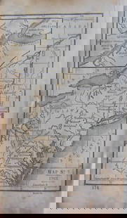
Heading: (Canada)
Author:
Title: Atlas of the Maritime Provinces of the Dominion of Canada, with historical and geological descriptions...
Place Published: St. John, N.B.
Publisher:Roe Brothers
Date Published: 1880
Description:
Author:
Title: Atlas of the Maritime Provinces of the Dominion of Canada, with historical and geological descriptions...
Place Published: St. John, N.B.
Publisher:Roe Brothers
Date Published: 1880
Description:
102 pp. Hand-colored maps; tables. (Folio) 40.5x32.5 cm (16x12¾"), publishers boards, rebacked.
Atlas with prefatory material regarding the geography and hydrography of Canadian lands.
Condition
Wear to boards, spine and corners professionally restored; pages with professional restoration; very good.
Buyer's Premium
- 30%
Hand-colored maps of Canada
Estimate $300 - $500
3 bidders are watching this item.
Shipping & Pickup Options
Item located in Berkeley, CA, usOffers In-House Shipping
Local Pickup Available
Payment

Related Searches
TOP