


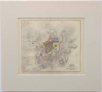
Map of Jerusalem. Braun & Hongenberg. Koln, 1572.
Similar Sale History


![[MAPS]. BRAUN, Georg (1541-1622) and HOGENBERG, Frans (1535...: [MAPS]. BRAUN, Georg (1541-1622) and HOGENBERG, Frans (1535-1590). Lugdunum. [Cologne, ca. 1572]. Hand-colored overhead view of Lyon engraved by Joris Hoefnagle (1542-1601). Text within decorative bor](https://p1.liveauctioneers.com/928/312808/167423213_1_x.jpg?height=310&quality=70&version=1702503866)


Recommended Items


![1575 Braun and Hogenberg Views of Southern Spain's Vegel and Velis Malaga -- Vegel [on sheet with]: Title: 1575 Braun and Hogenberg Views of Southern Spain's Vegel and Velis Malaga -- Vegel [on sheet with] Velis Malaga Cartographer: Braun and Hogenberg Year / Place: 1575, Augsberg Map Dimension (in.](https://p1.liveauctioneers.com/5584/330117/177981860_1_x.jpg?height=310&quality=70&version=1716324705)


Item Details
Description
Hierosolyma, Clarissima totius orientis Civitas Iudaee Metropolis. Two eras of Jerusalem in one map. On the left is Biblical Jerusalem in the first century of the counting, and on the right is modern Jerusalem of the 16th century. Separate legend for each era. By George Braun & Franz Hogenberg. From: Civitates Orbis Terrarum. Koln, 1572. Volume 1, p. 53. Page spread. First Latin edition. Colored, copperplate. Following Laicstain-De Jode. On the verso, p. 52, Latin text.
Latin. 34x48 cm. (leaf measures 41x53.5 cm.). Quality, thin, brown paper. Minimal aging stains. 2 small holes. Tears without loss. A few, clean worming marks where the pages are connected, on the back, not affecting text. Complete. Moderate condition.
Laor, 1039.
Latin. 34x48 cm. (leaf measures 41x53.5 cm.). Quality, thin, brown paper. Minimal aging stains. 2 small holes. Tears without loss. A few, clean worming marks where the pages are connected, on the back, not affecting text. Complete. Moderate condition.
Laor, 1039.
Buyer's Premium
- 25%
Map of Jerusalem. Braun & Hongenberg. Koln, 1572.
Estimate $800 - $1,200
Shipping & Pickup Options
Item located in Jerusalem, ilSee Policy for Shipping
Payment

Related Searches
TOP