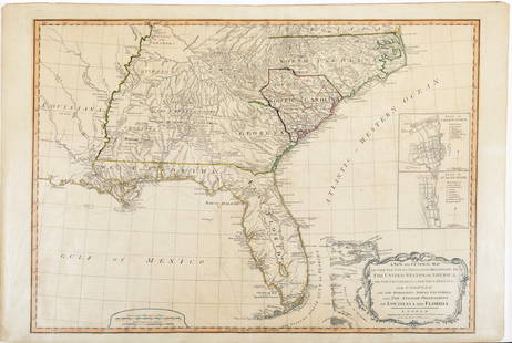
Homann: Map of British Colonies in North America 1740
Similar Sale History
View More Items in Maps & AtlasesRelated Maps & Atlases
More Items in Maps & Atlases
View MoreRecommended Transportation & Travel Collectibles
View More


Item Details
Description
The map shows British Possessions in North America in four panels. Top left: The gulf of St Lawrence with Newfoundland, New Brunswick and Nova Scotia. Top right: New England from Delaware Bay north to Nova Scotia, including the present day states of New York, New Jersey, Connecticut, Massachusetts, New Hampshire, Maine & Vermont. Many towns are marked including New York (on Long Island), Philadelphia, Boston, Plymouth. Bottom right: "Carolina". The Atlantic states from Chesapeake Bay to Northern Florida, including the present-day states of Virginia, North Carolina, South Carolina and Georgia. A number of towns are indicated, including "Charles Town"/Charleston, Port Royal and St Augustine. Bottom left: "Virginia and Maryland"; Chesapeake Bay, including the present-day state of Maryland. "Baltimore Town" is marked.
DATE PRINTED: c1740
IMAGE SIZE: Approx 53.5 x 59.5cm, 21 x 23.25 inches (Large); Please note that this is a folding map.
TYPE: Large antique 18th century atlas map, printed on thick, good quality paper with original outline hand colour/color divided into four panels showing (clockwise from top left) the maritime provinces of Canada, New England, the Carolinas with Georgia, and Chesapeake Bay, Virginia, maryland and Delaware
CONDITION: Very Good; suitable for framing.
VERSO: There is nothing printed on the reverse side, which is plain
FOLDING: This is a folding map.
ARTIST/CARTOGRAPHER/ENGRAVER: Johann Christoph Homann / Homann Heirs
PROVENANCE: The map was extracted from a composite atlas of early 18th century maps, the latest of which was dated c1754
Please note that this lot has a confidential reserve. When you leave a bid in advance of the auction, submit your maximum. The bidder who has submitted the highest bid wins the lot, provided the bid exceeds the reserve price.
Shipping:Domestic: Flat-rate of $24.00 to anywhere within the contiguous U.S. International: Foreign shipping rates are determined by destination. Location: This item ships from the United Kingdom
Your purchase is protected:
Photos, descriptions, and estimates were prepared with the utmost care by a fully certified expert and appraiser. All items in this sale are guaranteed authentic.
In the rare event that the item did not conform to the lot description in the sale, Jasper52 specialists are here to help. Buyers may return the item for a full refund provided you notify Jasper52 within 5 days of receiving the item.
DATE PRINTED: c1740
IMAGE SIZE: Approx 53.5 x 59.5cm, 21 x 23.25 inches (Large); Please note that this is a folding map.
TYPE: Large antique 18th century atlas map, printed on thick, good quality paper with original outline hand colour/color divided into four panels showing (clockwise from top left) the maritime provinces of Canada, New England, the Carolinas with Georgia, and Chesapeake Bay, Virginia, maryland and Delaware
CONDITION: Very Good; suitable for framing.
VERSO: There is nothing printed on the reverse side, which is plain
FOLDING: This is a folding map.
ARTIST/CARTOGRAPHER/ENGRAVER: Johann Christoph Homann / Homann Heirs
PROVENANCE: The map was extracted from a composite atlas of early 18th century maps, the latest of which was dated c1754
Please note that this lot has a confidential reserve. When you leave a bid in advance of the auction, submit your maximum. The bidder who has submitted the highest bid wins the lot, provided the bid exceeds the reserve price.
Shipping:
Your purchase is protected:
Photos, descriptions, and estimates were prepared with the utmost care by a fully certified expert and appraiser. All items in this sale are guaranteed authentic.
In the rare event that the item did not conform to the lot description in the sale, Jasper52 specialists are here to help. Buyers may return the item for a full refund provided you notify Jasper52 within 5 days of receiving the item.
Buyer's Premium
- 15%
Homann: Map of British Colonies in North America 1740
Estimate $900 - $1,000
2 bidders are watching this item.
Get approved to bid.
Shipping & Pickup Options
Item located in United Kingdom$24 shipping in the US
Payment
See More Items From This Jasper52 Seller

Auction Curated By

Maps Expert
TOP


![Mitchell Map of the British and French Dominions of North America, 1755 - VERY RARE FIRST EDITION,: MITCHELL, John (1711-1768). A Map of the British and French Dominions of North America. Engraved map in 8 sheets. Published [London:] Publish'd by the Author Feb.ry 13th. 1755, and Sold by And: Miller](https://p1.liveauctioneers.com/1968/282833/149849101_1_x.jpg?height=310&quality=70&version=1680275215)


![Map of Virginia, Carolinas and Georgia from Marshall's Life of Washington: [Marshall's Life of Washington]. Map of part of Virginia North Carolina South Carolina & Georgia which were the scenes of the most important Operations of the Southern Armies. Engraved map, by J. Yeag](https://p1.liveauctioneers.com/1968/322135/173185711_1_x.jpg?height=310&quality=70&version=1709997984)

![Map of New York from Marshall's Life of Washington: [Marshall's Life of Washington]. Plan of New York Island and part of Long Island Shewing the Position of the American & British Armies before, at, and after the Engagement on the Heights August 27th 1](https://p1.liveauctioneers.com/1968/322135/173185714_1_x.jpg?height=310&quality=70&version=1711031437)
![Map of New York Marshall's Life of Washington: [Marshall's Life of Washington]. Plan of the Country from Frogs Point to Croton River Shewing the Positions of the American & British Armies from the 12th of Oct. 1776 until the Engagement of the Whit](https://p1.liveauctioneers.com/1968/322135/173185715_1_x.jpg?height=310&quality=70&version=1709997984)


![Bernard / Miller Manuscript Map of the Great Eastern: [Map - Colonial New England] [BERNARD, Sir Francis, Governor of Colonial Massachusetts (1712-1779) & Francis MILLER, Surveyor (1733-1800). Untitled Manuscript Road Map of "The Great Eastern Road." [Ro](https://p1.liveauctioneers.com/1968/225974/116712071_1_x.jpg?height=310&quality=70&version=1636655147)


![[Maps] Gio. Ant. Magnini, Italia, 1620: [Maps] Gio. Ant. Magnini, Italia, 1620, Giovanni Antonio Magnini. Italia, data in luce da Fabio suo figliuolo al Serenissimo Ferdinado Gonzaga Duca di Matoua edi Monserrato etc. Bologna, for Sebastian](https://p1.liveauctioneers.com/188/326797/176317457_1_x.jpg?height=310&quality=70&version=1713847031)
![[Maps] Martin Zeiler, Itinerarium Italiae, 1640: [Maps] Martin Zeiler, Itinerarium Italiae, 1640, Martini Zeilleri. Itinerarium Italiae Nov-Antiquae: oder, Raiss-Beschreibung durch Italien, Matthaus Merian, Frankfurt, 40 plates, most double-page, in](https://p1.liveauctioneers.com/188/326797/176317459_1_x.jpg?height=310&quality=70&version=1713847031)


