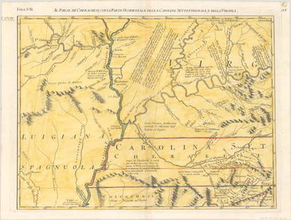
ANTONIO ZATTA (ITALIAN, 18TH CENTURY) MAP OF VIRGINIA
Similar Sale History
View More Items in Maps & AtlasesRelated Maps & Atlases
More Items in Maps & Atlases
View MoreRecommended Transportation & Travel Collectibles
View More


Item Details
Description
ANTONIO ZATTA (ITALIAN, 18TH CENTURY) MAP OF VIRGINIA AND MARYLAND, hand-colored, on laid paper, title and plate number to top margin "FOGL. VIII. IL MARYLAND, IL JERSEY MERIDIONALE, LA DELAWARE, E LA PARTE ORIENTALE DELLA VIRGINIA, E CAROLINA SETTENTRIONALE", from "Le Colonie Unite dell' America Settentr'le", published 1778. Unframed. Circa 1778. 12 3/8" x 16 5/8" to neat lines, 15" x 20" OA.
Excellent condition overall, expected fold-line with some discoloration, expected minor toning.
Literature: Parallels William C. Woolridge - Mapping Virginia: From the Age of Exploration to the Civil War, p. 134, pl. 124.
Provenance: Property Deaccessioned by the Colonial Williamsburg Foundation, Williamsburg, Virginia. All proceeds to benefit the Collections Acquisitions Fund.
Condition
Excellent condition overall, expected fold-line with some discoloration, expected minor toning.
Buyer's Premium
- 24.5%
ANTONIO ZATTA (ITALIAN, 18TH CENTURY) MAP OF VIRGINIA
Estimate $100 - $150
3 bidders are watching this item.
Shipping & Pickup Options
Item located in Mt. Crawford, VA, usSee Policy for Shipping
Payment

Related Searches
TOP


![[MAP]. ORTELIUS, Abraham. Peregrinationis Divi Pauli Typus Corographicus. 1592.: [MAP]. ORTELIUS, Abraham (1527-1598). Peregrinationis Divi Pauli Typus Corographicus. Antwerp, 1592. Engraved map with hand-coloring. Matted, framed, and double glazed, visible area 381 x 533 mm (unex](https://p1.liveauctioneers.com/197/329395/177650535_1_x.jpg?height=310&quality=70&version=1715364962)


![[MAP]. TODESCHI, Pietro. [Nova et Acurata Totius Americae Tabula auct. G.I. Blaeu] America quarta: [MAP]. TODESCHI, Pietro. [Nova et Acurata Totius Americae Tabula auct. G.I. Blaeu] America quarta pars orbis quam plerunq, nuvum orbem appellitant primo detecta est anno 1492 a Christophoro Columbo...](https://p1.liveauctioneers.com/197/329395/177650542_1_x.jpg?height=310&quality=70&version=1715364962)


![[MAPS]. HOMANN, Johann Baptist, HOMANN HEIRS, and Georg Matthäus SEUTTER. [Composite Atlas].: [MAPS]. HOMANN, Johann Baptist (1663-1724), HOMANN HEIRS, and Georg Matthäus SEUTTER (1678-1757). [Composite Atlas]. [Nuremberg, Augsburg, and others: Homann Heirs and others, maps dated between](https://p1.liveauctioneers.com/197/329395/177650530_1_x.jpg?height=310&quality=70&version=1715364962)


![[MAP]. ORTELIUS, Abraham. Turcici Imperii Descriptio.1592.: [MAP]. ORTELIUS, Abraham (1527-1598). Turcici Imperii Descriptio. Antwerp, 1592. Engraved map with hand-coloring. Matted, framed, and double glazed, sight 406 x 521 mm (unexamined out of frame). Decor](https://p1.liveauctioneers.com/197/329395/177650538_1_x.jpg?height=310&quality=70&version=1715364962)
![[MAP]. ORTELIUS, Abraham. Americae Sive Novi Orbis, Nova Descriptio. 1573.: [MAP]. ORTELIUS, Abraham (1527-1598). Americae Sive Novi Orbis, Nova Descriptio. Antwerp, 1573. Engraved map with hand-coloring. Framed and double glazed, visible area 375 x 521 mm (unexamined out of](https://p1.liveauctioneers.com/197/329395/177650534_1_x.jpg?height=310&quality=70&version=1715364962)

![[MAP]. ORTELIUS, Abraham. Aevi Veteris, Typus Geographicus. 1601.: [MAP]. ORTELIUS, Abraham (1527-1598). Aevi Veteris, Typus Geographicus. Antwerp, 1601. Engraved map with hand-coloring. Matted, framed, and double glazed, visible area 343 x 470 mm (unexamined out of](https://p1.liveauctioneers.com/197/329395/177650532_1_x.jpg?height=310&quality=70&version=1715364962)


![[FLAGS]. 31-star American parade flag. Ca 1850-1859.: [FLAGS]. 31-star American parade flag. Ca 1850-1859. 22 x 36 1/2 in. cotton flag with 31 printed stars, configured in a double medallion surrounding a much larger central star, that is haloed in both](https://p1.liveauctioneers.com/197/329785/177758218_1_x.jpg?height=310&quality=70&version=1715625218)


