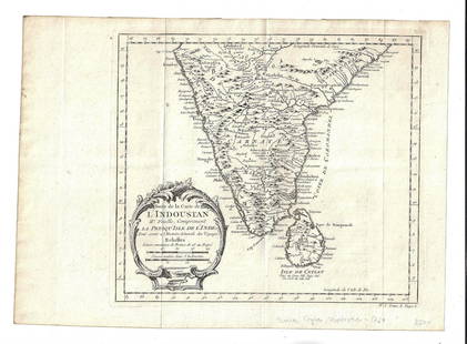
India & Ceylon 1750's Map by Bolton, Bowen & d'Anville
Similar Sale History
Recommended Items


Item Details
Description
"Asia, plate 4" Showing India & Ceylon by Solomon Bolton, after d'Anville's earlier map. One sheet only (of 4) Engraved by E. Bowen. Published 1751-57, London for "The Universal Dictionary of Trade and Commerce" by Malachy Postlethwayt. Paper Size: 18.5 x 16 inch (47 x 40cm) Faults present. Several background holes and wrinkles. A few margin tears, one extending near to image.
Buyer's Premium
- 22%
India & Ceylon 1750's Map by Bolton, Bowen & d'Anville
Estimate $20 - $25
1 bidder is watching this item.
Get approved to bid.
Shipping & Pickup Options
Item located in Chesterfield, ukSee Policy for Shipping
Payment

TOP


![[MAP] TACHARD, G. CARTE MARINE [INDIA, ETC.] 1701: Tachard Guy. CARTE MARINE Depius Suratte jusqu'au Detroit de Malaca Dressee par le R.P. Tachard de la Compangnie de Jesus... Paris: I.B. Nolin [Jean-Baptiste Nolin], 1701. Map showing India, Ceylon (S](https://p1.liveauctioneers.com/8124/310027/165853627_1_x.jpg?height=310&quality=70&version=1700184289)


![1750 Bowen Map of Bermuda and St. Kitts -- A New & Accurate Map of Bermudas or Sommer's Islands...: Title: 1750 Bowen Map of Bermuda and St. Kitts -- A New & Accurate Map of Bermudas or Sommer's Islands... [on sheet with] An Accurate Map of the Island of St. Christopher… Cartographer: E Bowen](https://p1.liveauctioneers.com/5584/330117/177981806_1_x.jpg?height=310&quality=70&version=1716324705)


