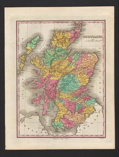
2 MAPS FRAMED, SCOTLAND OF OLD, IRELAND, BULLOCK MAPS
Similar Sale History
View More Items in Maps & AtlasesRelated Maps & Atlases
More Items in Maps & Atlases
View MoreRecommended Transportation & Travel Collectibles
View More


Item Details
Description
Two framed maps, Scotland of Old and Ireland. Windowbox style frames. 1969 Bullock Pictorial Historical Map of Ireland - This is a delightful 1969 L.G. Bullock pictorial historical map of Ireland. Bullock's map shows the entire Emerald Isle as well as a small amount of the sea. The map is very elaborate and includes several intriguing aspects. At first glance, the small sketches of Irish dancers, country folk, and the Viking invasion pop out at the viewer. Quotations from famous Irish people are sprinkled throughout the map, as well as folk sayings and inscriptions. Historic cathedrals and abbeys are marked with yellow crosses, castles are marked by small brown castles, and other historic sites are shown as well. Important battles and sieges from Irish history are strewn across the map, some of which happened in the same place hundreds of years apart. The names of ancient clans and families in included on the map as well, allowing people to trace their lineage back to a certain area of Ireland. The map is framed by the crests of Irish cities and towns, including Belfast, Dublin, and Cork, as well as the crests of the National University of Ireland and Queen's University-Belfast.SOCTLAND OF OLD - This map was created by L.G. Bullock and printed and published in Great Britain by John Bartholomew and Sons Ltd. of Edinburgh. The Collins Scotland of Old Clans Map is a unique pictorial map showing the ancient territories of the principal Scottish clans in the 17th century, and features Don Pottinger's (Islay Herald of Arms) distinctive and original artwork of Scottish arms and crest badges. The map includes: * Over 170 arms, the official insignia of clan chiefs, and crest badges. * Territories map of principal clans at the beginning of the 17th century. * Arms of the ancient Scottish principalities. * Locations of the ancient territories held by the clans around the time of King James VI. The map is ideal for those those with an interest in Scottish heraldry, clans and family history. Did you know that Scotland is one of the few countries in the world where a court of heraldry and genealogy operates on a daily basis? The map is based on the map originally conceived and illustrated by the late Sir Iain Moncreiffe of that Ilk, Bart., C.V.O., Q.C., Ph.D., Albany Herald of Arms, and the late Don Pottinger, C.V.O., M.A., D.A., Islay Herald of Arms. Discover the other titles in the series, including Collins Tartans Map of Scotland, Castles Map of Scotland and Whisky Map of Scotland. (info from their website)
Buyer's Premium
- 19%
2 MAPS FRAMED, SCOTLAND OF OLD, IRELAND, BULLOCK MAPS
Estimate $100 - $200
1 bidder is watching this item.
Shipping & Pickup Options
Item located in Englewood, FL, usSee Policy for Shipping
Payment

Related Searches
TOP


![1876 Mitchell Map of France, Spain, Portugal, Switzerland [verso] Ireland and Scotland -- Map of: Title: 1876 Mitchell Map of France, Spain, Portugal, Switzerland [verso] Ireland and Scotland -- Map of France, Spain and Portugal [verso] Ireland in Provinces and Counties [and] County Map of Scotlan](https://p1.liveauctioneers.com/5584/283091/149355449_1_x.jpg?height=310&quality=70&version=1680038985)


![Isles Britanniques Angleterre, Ecosse & Irlande.: TITLE/CONTENT OF MAP: 'Isles Britanniques, contenant les Royaumes d'Angleterre, d'Ecosse et d'Irlande [The British Isles, containing the Kingdoms of England, Scotland and Ireland]' This map is folding](https://p1.liveauctioneers.com/5584/138985/70466087_1_x.jpg?height=310&quality=70&version=1554250661)

![A block puzzle with maps of Europe, England, Ireland, Scotland, America and the World: [BLOCK PUZZLE] Boxed set of 20 cubical blocks, each face with a portion of one of six hand-colored lithographed maps. Probably Irish: mid-nineteenth century. Blocks overall 7 5/8 x 6 1/4 inches (19.5](https://p1.liveauctioneers.com/292/330597/178279620_1_x.jpg?height=310&quality=70&version=1716409282)


![Americae Australis / Peruana by Bertius / Langenes. South America 1603 old map: CAPTION PRINTED BELOW PICTURE: Descriptio Americae Australis / Peruana [South America & Terra Australis] The map shows part of Terra Australia incognita in the southern Atlantic Ocean DATE PRINTED: 16](https://p1.liveauctioneers.com/5584/330116/177980378_1_x.jpg?height=310&quality=70&version=1716324705)


![[MAP]. TODESCHI, Pietro. [Nova et Acurata Totius Americae Tabula auct. G.I. Blaeu] America quarta: [MAP]. TODESCHI, Pietro. [Nova et Acurata Totius Americae Tabula auct. G.I. Blaeu] America quarta pars orbis quam plerunq, nuvum orbem appellitant primo detecta est anno 1492 a Christophoro Columbo...](https://p1.liveauctioneers.com/197/329395/177650542_1_x.jpg?height=310&quality=70&version=1715364962)


![[MAPS]. HOMANN, Johann Baptist, HOMANN HEIRS, and Georg Matthäus SEUTTER. [Composite Atlas].: [MAPS]. HOMANN, Johann Baptist (1663-1724), HOMANN HEIRS, and Georg Matthäus SEUTTER (1678-1757). [Composite Atlas]. [Nuremberg, Augsburg, and others: Homann Heirs and others, maps dated between](https://p1.liveauctioneers.com/197/329395/177650530_1_x.jpg?height=310&quality=70&version=1715364962)


![[MAP]. ORTELIUS, Abraham. Turcici Imperii Descriptio.1592.: [MAP]. ORTELIUS, Abraham (1527-1598). Turcici Imperii Descriptio. Antwerp, 1592. Engraved map with hand-coloring. Matted, framed, and double glazed, sight 406 x 521 mm (unexamined out of frame). Decor](https://p1.liveauctioneers.com/197/329395/177650538_1_x.jpg?height=310&quality=70&version=1715364962)
![[MAP]. ORTELIUS, Abraham. Americae Sive Novi Orbis, Nova Descriptio. 1573.: [MAP]. ORTELIUS, Abraham (1527-1598). Americae Sive Novi Orbis, Nova Descriptio. Antwerp, 1573. Engraved map with hand-coloring. Framed and double glazed, visible area 375 x 521 mm (unexamined out of](https://p1.liveauctioneers.com/197/329395/177650534_1_x.jpg?height=310&quality=70&version=1715364962)

![[MAP]. ORTELIUS, Abraham. Aevi Veteris, Typus Geographicus. 1601.: [MAP]. ORTELIUS, Abraham (1527-1598). Aevi Veteris, Typus Geographicus. Antwerp, 1601. Engraved map with hand-coloring. Matted, framed, and double glazed, visible area 343 x 470 mm (unexamined out of](https://p1.liveauctioneers.com/197/329395/177650532_1_x.jpg?height=310&quality=70&version=1715364962)


![[FLAGS]. 31-star American parade flag. Ca 1850-1859.: [FLAGS]. 31-star American parade flag. Ca 1850-1859. 22 x 36 1/2 in. cotton flag with 31 printed stars, configured in a double medallion surrounding a much larger central star, that is haloed in both](https://p1.liveauctioneers.com/197/329785/177758218_1_x.jpg?height=310&quality=70&version=1715625218)


