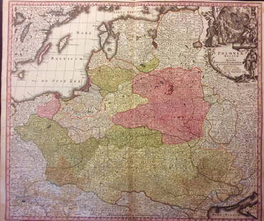
A 17th Century Map of Poland, lithuania, Ukraine,
Similar Sale History
View More Items in Maps & AtlasesRelated Maps & Atlases
More Items in Maps & Atlases
View MoreRecommended Transportation & Travel Collectibles
View More


Item Details
Description
Johannes de Ram, c.1690, titled 'Regni Poloniae et Ducatus Lithuaniae Volhyniae, Podoliae, Ucraniae, Livoniae et Curlandiae, Descriptio, Ementata de Johannes de Ram', Copperplate engraving original uncoloured, cartouche in bottom left corner showing traders with a camel and a monkey, cartouche to right showing key to symbols, dimensions 58cm x 50cm.
Note: we have been unable to find this map in this form with these 3 cartouche designs
Note: we have been unable to find this map in this form with these 3 cartouche designs
Buyer's Premium
- 20%
A 17th Century Map of Poland, lithuania, Ukraine,
Estimate £80 - £120
14 bidders are watching this item.
Shipping & Pickup Options
Item located in Reading, ukSee Policy for Shipping
Payment

TOP


![An antique map of Poland by Izaak Tirion, circa 1740: An antique map of Poland by Izaak Tirion, circa 1740 Title: [Old Antique map of Poland / Lithuania] Nieuwe Kaart van het Koninkryk Poolen. Author: Tirion, Izaak , Amsterdam, c. 1740. Descri](https://p1.liveauctioneers.com/6018/113868/58519818_1_x.jpg?height=310&quality=70&version=1513369839)


![Il Regno d'Ungaria, Transilvania… Bosnia, Croatia… DE ROSSI / SANSON 1683 map: TITLE/CONTENT OF MAP: Il Regno d'Ungaria, Transilvania, Schiavonia, Bosnia, Croatia, Dalmatia [The Kingdoms of Hungary, Transylvania, Slavonia, Bosnia, Croatia, Dalmatia] Part of central and south-eas](https://p1.liveauctioneers.com/5584/328641/177014161_1_x.jpg?height=310&quality=70&version=1715113718)


![[Maps] Gio. Ant. Magnini, Italia, 1620: [Maps] Gio. Ant. Magnini, Italia, 1620, Giovanni Antonio Magnini. Italia, data in luce da Fabio suo figliuolo al Serenissimo Ferdinado Gonzaga Duca di Matoua edi Monserrato etc. Bologna, for Sebastian](https://p1.liveauctioneers.com/188/326797/176317457_1_x.jpg?height=310&quality=70&version=1713847031)
![[Maps] Martin Zeiler, Itinerarium Italiae, 1640: [Maps] Martin Zeiler, Itinerarium Italiae, 1640, Martini Zeilleri. Itinerarium Italiae Nov-Antiquae: oder, Raiss-Beschreibung durch Italien, Matthaus Merian, Frankfurt, 40 plates, most double-page, in](https://p1.liveauctioneers.com/188/326797/176317459_1_x.jpg?height=310&quality=70&version=1713847031)


