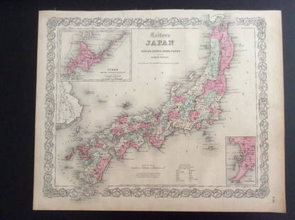
Japan Map by NAGAKUBO SEKISUI, 1811
Similar Sale History
View More Items in Maps & AtlasesRelated Maps & Atlases
More Items in Maps & Atlases
View MoreRecommended Transportation & Travel Collectibles
View More


Item Details
Description
*** START PRICE IS THE RESERVE ***
[Asia] NAGAKUBO SEKISUI.
[A Revised Route Map of Japan showing the fiefs and distances]
Multi-sheet woodcut map
c. 1811.
130 x 84 cm.
A multi-sheet woodcut map, showing Japan orientated north west to south east, compass roses, with various text blocks giving information on roads, crops of each Daimyo, their crests, Eki (an old system where a horse and labourer were available for travel), inns, famous places, historic spots, shrines & temples.
An important 19th century administrative map of Japan, Nagakubo's route map of Japan redevised the traditional Ryusen form the map of Japan introducing for the first time graticule lines of latitudes and meridians, allowing more accurate readings of position. This new form first appeared in 1779, the map being republished and revised in 1791, 1811, 1833, 1840 after his death. It became the standard form for the map of Japan for over a century.
Buyer's Premium
- 20%
Japan Map by NAGAKUBO SEKISUI, 1811
Estimate $12,000 - $18,000
Get approved to bid.
Shipping & Pickup Options
Item located in New York, New York, usOffers In-House Shipping
Local Pickup Available
Payment

TOP


![Ortelius: First Map of Japan in European Atlas, 1595: Title: Iaponiae Insulae Descriptio. Ludoico Teisera Auctore. [first map of Japan published in European atlas] Map maker: Abraham Ortelius, Theatrum Orbis Terrarum Place and Year: Antwerp, 1595 Dimensi](https://p1.liveauctioneers.com/5584/108292/55552479_1_x.jpg?height=310&quality=70&version=1503667951)


![[MAP]. TODESCHI, Pietro. [Nova et Acurata Totius Americae Tabula auct. G.I. Blaeu] America quarta: [MAP]. TODESCHI, Pietro. [Nova et Acurata Totius Americae Tabula auct. G.I. Blaeu] America quarta pars orbis quam plerunq, nuvum orbem appellitant primo detecta est anno 1492 a Christophoro Columbo...](https://p1.liveauctioneers.com/197/329395/177650542_1_x.jpg?height=310&quality=70&version=1715364962)


![[MAP]. ORTELIUS, Abraham. Americae Sive Novi Orbis, Nova Descriptio. 1573.: [MAP]. ORTELIUS, Abraham (1527-1598). Americae Sive Novi Orbis, Nova Descriptio. Antwerp, 1573. Engraved map with hand-coloring. Framed and double glazed, visible area 375 x 521 mm (unexamined out of](https://p1.liveauctioneers.com/197/329395/177650534_1_x.jpg?height=310&quality=70&version=1715364962)
![[MAPS]. HOMANN, Johann Baptist, HOMANN HEIRS, and Georg Matthäus SEUTTER. [Composite Atlas].: [MAPS]. HOMANN, Johann Baptist (1663-1724), HOMANN HEIRS, and Georg Matthäus SEUTTER (1678-1757). [Composite Atlas]. [Nuremberg, Augsburg, and others: Homann Heirs and others, maps dated between](https://p1.liveauctioneers.com/197/329395/177650530_1_x.jpg?height=310&quality=70&version=1715364962)


![[MAP]. ORTELIUS, Abraham. Turcici Imperii Descriptio.1592.: [MAP]. ORTELIUS, Abraham (1527-1598). Turcici Imperii Descriptio. Antwerp, 1592. Engraved map with hand-coloring. Matted, framed, and double glazed, sight 406 x 521 mm (unexamined out of frame). Decor](https://p1.liveauctioneers.com/197/329395/177650538_1_x.jpg?height=310&quality=70&version=1715364962)

![[MAP]. ORTELIUS, Abraham. Aevi Veteris, Typus Geographicus. 1601.: [MAP]. ORTELIUS, Abraham (1527-1598). Aevi Veteris, Typus Geographicus. Antwerp, 1601. Engraved map with hand-coloring. Matted, framed, and double glazed, visible area 343 x 470 mm (unexamined out of](https://p1.liveauctioneers.com/197/329395/177650532_1_x.jpg?height=310&quality=70&version=1715364962)


![[FLAGS]. 31-star American parade flag. Ca 1850-1859.: [FLAGS]. 31-star American parade flag. Ca 1850-1859. 22 x 36 1/2 in. cotton flag with 31 printed stars, configured in a double medallion surrounding a much larger central star, that is haloed in both](https://p1.liveauctioneers.com/197/329785/177758218_1_x.jpg?height=310&quality=70&version=1715625218)


