Sold2024Duval - Pair: Map of India & Map of MaldivesThis fascinating map is from Pierre Duval. It was part of a composite or collector's atlas of his maps. It was done in Paris circa 1670s. The composite atlas originally included maps from the followinSee Sold Price
Sold20181713 Voyages of Tavernier Persia Iran India MAP1713 Voyages of Tavernier Persia Iran India MAP Illustrated Maldives Jean-Baptiste Tavernier was an important 17th-century voyager known for his six voyages to Persia and India in which he bought, solSee Sold Price
Sold2023Duval - Map of IndiaThis fascinating map is from Pierre Duval. It was part of a composite or collector's atlas of his maps. It was done in Paris circa 1670s. The composite atlas originally included maps from the followinSee Sold Price
Sold2024Barclay, James 1808 Antique Map. India, Ceylon & Maldives"Hindoostan with the Islands of Ceylon, Maldivas &c &c." Copper Engraved Map Published 1806, London for "Barclay's Complete and Universal English Dictionary" by the Rev. James Barclay. Paper Size: 10See Sold Price
Sold2021Nolan, Edward C1880 Pair of Maps of India"India. The Bombay Presidency/India. The Madras Presidency" and "India The Bengal Presidency" Steel Engraved Map Published C1880, London for "The Illustrated History of the British Empire in India andSee Sold Price
Sold2021Gleig, G. R. 1858 Pair of Maps of India. WellingtonSteel Engraved Map Published 1858, London for "History of the Life of Arthur Duke of Wellington" by the Rev. G. R. Gleig. Folds as issued. Paper Size: Up to 11.5 x 9 inch (29 x 23cm)Minor offsetting oSee Sold Price
Sold2019Blackie & Weller 1882 Pair of Maps of IndiaIndia and India South Part. Lithograph Maps Published 1882 by Blackie & Son, London for "The Comprehensive Atlas & Geography of the World" by W. G. Blackie. Maps by Edward Weller. Centre fold as issueSee Sold Price
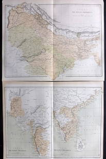
Sold2022Reclus, Elisee C1880 Pair of Maps of IndiaLithograph Maps Published 1876-94, London for "The Universal Geography" by Elisee Reclus. Edited by A. H. Keane. Folds as issued. Paper Size: 14 x 10.5 inch (36 x 27cm) Approx. Good ConditionSee Sold Price
Sold2017Maldives, Male, Atolls, Sri Lanka Map, Mallet, 1683TITLE OF THE MAP: 'Isles des Maldives' The map includes Southern India & Ceylon (Sri Lanka) as well as the Maldive Islands. The cartouche is particulary attractive. DATE PRINTED: 1683 IMAGE SIZE: ApprSee Sold Price
Sold2019Barclay, James 1809 Antique Map. India & Ceylon"Hindoostan with the Island of Ceylon, Maldives &c &c" Outline Hand Coloured Copper Engraved Map Published 1809, Leeds for "Barclay's Complete and Universal Dictionary of the English Language..." by tSee Sold Price
Sold2018India 1882 Pair of Maps by BlackieLithograph Maps Published 1882 by Blackie & Son, London for "The Comprehensive Atlas & Geography of the World" by W. G. Blackie. Paper Size: 22 x 15 inch (56 x 38cm) Small margin tear to one. Good conSee Sold Price
Sold2017Bonne: Map of South India Ceylon Maldives, 1780Title/Content of Map: 'Carte de la Partie Inferieure de l' Inde en deça du Gange' The map covers south India including the Malabar and Coromandel coasts, Sri Lanka/Ceylon, The Laccadives, the MaldiveSee Sold Price
Sold2017Bonne: Antique Map of Southern India, 1780Title/Content of Map: 'Carte de la Partie Inferieure De L'Inde En Deca Du Gange' A map of Southern India, the Maldives, Sri Lanka, and the Andaman & Nicobar Islands Date Printed: 1780 Image Size: ApprSee Sold Price
Sold2020Grp: 7 Maps of IndiaGroup of seven maps of India. Includes two hand colored maps by Pierre Duval (1618-1683), "Presquisle de L'Inde de ca le Gange" and "Empire Du Mogol"; three maps by Girolamo Ruscelli (1500-1566), "TabSee Sold Price
Sold2017Tardieu: Antique Map of Southern India & Ceylon, 1795Title/Content of Map: 'Inde Partie Meridionale de la Presqu'isle en deca du Gange' A map of Southern India and Ceylon (Sri Lanka), including the Laccadives and northern Maldives. Mentelle/Chanlaire. ISee Sold Price
Sold2020Bartholomew, John 1922 Pair of Maps. East Indies"Farther India" and "Malay Archipelago" Large Lithograph Maps Published 1922 by The Times, London for "The Times Survey Atlas of the World" Maps by John George Bartholomew of the Edinburgh GeographicaSee Sold Price
Sold2019Bartholomew, John 1922 Pair Large Maps of East Indies"Farther India" showing Siam, Indonesia, Singapore, Malaysia. Together with "Malay Archipelago" Large Lithograph Map Published 1922 by The Times, London for "The Times Survey Atlas of the World" MapsSee Sold Price
Sold2019Japan C1880 Pair of Maps by Nolan & Blackie"The Islands of Japan with Corea..." Steel Engraved Map Published C1880, London for "The Illustrated History of the British Empire in India and the East" by Edward H. Nolan. Centre fold as published.See Sold Price
Sold20231752 Northern India. Map by BellinTitle: 1752 Northern India. Map by Bellin Date/Period: 1752 Materials: Copperplate engraved Size: 15 1/4” x 10” This 1752 antique map by Jacques Nicolas Bellin depicts all of northern IndiSee Sold Price
Sold2017Rand McNally Map India, Burma, Nepal and Ceylon, 1898Map: 1898 Rand McNally India, Burma, Nepal and Ceylon -- India Cartographer: Rand McNally Year / Place: 1898, Chicago Map Dimension: 26.2 X 19.2 in. A very nice map of South East Asia. Highly detailedSee Sold Price
Sold2024Vintage Sterling India Map Compact MirrorMeasures 3 inches across and features 5 small ruby gemstones. Sterling silver with gold map inlay. Very unique! DWT 58See Sold Price
Sold2017Colton: Hindostan (British India) MapHindostan (or British India), 14 x 17 in, 1857, J. H. Colton Please note that this lot has a confidential reserve. When you leave a bid in advance of the auction, submit your maximum. Jasper52 will biSee Sold Price
Sold2016Antique Map : India - 1802Antique Map : India - 1802 from Walker's Geography & Gazette. Size : 10.25" x 8"See Sold Price
Sold20211895 India MapAuthor: Cram Title: 1895 India Map Medium: Ink on Paper Dimenions: 15"X22" Description: Map of India dated 1895. Printed by George Cram for Walker's International Atlas. Published in Chicago and New YSee Sold Price
Jun 12Dan Morphy AuctionsPLATE CXIII. MAP OF INDIAN TERRITORY SHOWING DISTRIBUTION OF WOODLAND” FROM THE TWENTY-FIRST$100
Jun 07Freeman's | HindmanBELLIN, Jacques-Nicolas. Carte Reduite de L'Ocean Oriental ou Mer Des Indies. Paris, 1757. Second$150
Featured4 days LeftJasper52c1720 World showing Dutch East India Co possessions. CA as a island. By J.Malherbe$600