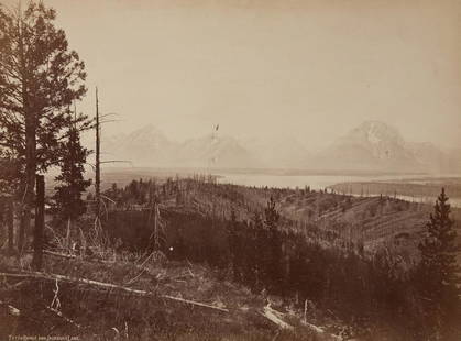
Sold2020W H JACKSON famous view of TETONS 1972WILLIAM HENRY JACKSON Teton Range And Jackson Lake, 1872 Albumen Print 9.6x12.6" ASG# WHJ/3511 on larger mount Famous early photographs of the Grand Tetons, Wyoming during the Hayden Survey. William HSee Sold Price
Sold2021EARLY MARYLAND REAL ESTATE DOCUMENTS - ANNE ARUNDEL CO.Includes: (1) Attorney letter, re: Benjamin Nicholson vs. Lewis Weston concerning parcel of lands "Flushing" and "Deep Creek" Anne Arundel Co., to re-survey land patented to Thomas Turner in 1649; attSee Sold Price
Sold2023George Washington Signed Written Land Survey 1776Exceptional George Washington Signed Handwritten Land Survey Dated 1776. We are honored to present an extraordinary piece of American history: an authentic and rare land survey handwritten and signedSee Sold Price
Sold2023Shanghai District Land Survey map, 1937Title/Content of Map: Shanghai District Land Survey map, 1937 Date Printed: 1937 Cartographer: Land Survey Department Material/Medium: paper Size: 108cm x 78cm Provenance: Bought from long time AsianSee Sold Price
Sold20171815 South Carolina Land Survey & 1829 DeedPen & ink, hand drawn survey map with coloring, dated July 28, 1815 describing 211 acres on Tiger River in Union District belonging to William Linam, William Lucas and heirs of Jeremiah Hamilton, Esq.See Sold Price
Sold2023A Large Group of Cincinnati Land Survey MapsCourthouse survey maps of downtown Cincinnati Ohio and its wards, lot includes Cincinnati embracing its wards Part X, V, III, VI, IV, I and II; largest 42 x 22 inches. Overall good condition.See Sold Price
Sold20161831 South Carolina Hand-Drawn Land Surveydated and completed at the request of Mr. Jackson Evans, the plat records a 50 acre track in the Newberry district of South Carolina along the banks of the Tiger River and the Cain Creek. The old 96 rSee Sold Price
Sold2021LAND SURVEY DOCUMENTS ANNE ARUNDEL CO, 1814-1886Includes: (1) Courses of "Howard's Pasture Resurveyed" for Charles Waters 8/19/1805, mentions "Stevensons Addition" and "Gambrills Purchase", laid out 237 acres; G; (1) Platt and Courses for "PopularSee Sold Price
Sold2022Early Georgia Manuscript Land SurveySurveyor General's Office, Milledgeville, Georgia, July 22, 1858. Folio sheet. A partially printed document completed in manuscript, being a true copy of a late 18th century land survey in Wilkes CounSee Sold Price
Sold20231897 Cincinnati Price Hill Land Surveys and DocumentsAmerica, 19th century. A lot of spectacular early planning maps of Cincinnati's West Side area, including Price Hill. Details subdivisions charted by Peter Neff and J.W. Burnet. Platted by EarnshaSee Sold Price
Sold2017SCIENTOLOGIST / REINCARNATION FIRST-EDITION VOLUMESCIENTOLOGIST / REINCARNATION FIRST-EDITION VOLUME, "Have You Lived Before This Life? A Scientific Survey," by L. Ron Hubbard, London: The Hubbard Association of Scientologists International Limited,See Sold Price
2023George Washington Signed Partial DocumentExquisite George Washington Signed Partial Document from a Land Survey, Elegantly Framed. We are thrilled to present an extraordinary item of considerable historical importance -a partial document sigSee Sold Price
Sold202417th C. Land Documents17th C. Land Documents, includes: 1682 Survey of land at Chesapeake Bay for Samuel Jackson; Charles II 1684 land grant to Charles Hopkins (on parchment) Somerset County Maryland; and a 1734 IndentureSee Sold Price
Sold20211794 Georgia Land Grant Survey & Wax Seal Framed18th century. Hand drawn Georgia land survey with original wax seal. Very nice framed for display. Framed: H32" W12 1/2" Sold from the collection of a Greenville gentleman collector.See Sold Price
Sold20211794 Georgia Land Grant Survey & Wax Seal Framed18th century. Hand drawn Georgia land survey with original wax seal. Very nice framed for display. Framed: H32" W12 1/2" Sold from the collection of a Greenville gentleman collector.Montgomery Co Ga aSee Sold Price
Sold2017PAINTING OF SOLDIERS ON GREEN MOUNTAINPainting Of Soldiers On Green Mountain: Soldiers walk along a mountain path holding red flags. They look toward the waterfall and survey the land. Calligraphy and artist seal on left.See Sold Price
Sold20241736 LARGE MAP OF SILESIA POLAND KARNOVIENSIS antique 25 x 4 3/4" Duchy of KrnovPrincipatus Silesiae KARNOVIENSIS by HOMANN HEIRS Nuremberg, 1736 The land survey was done by J. W. Wieland, and corrected by M. v. Schubarth. With a large very attractive cartouche in the upper leftSee Sold Price
Sold2017Two New York MapsOne a map of The Highland and the Highlands of Hudson County, from actual survey's by James P Kirby PC. The second a property map. Together with a land survey of lands owned by The Deer Hill Company LSee Sold Price
Sold20212 Wisconsin Documents incl 1864 OfficersAlso includes 1848 Wisconsin Territory public land survey. From the Estate Collection of Stephen R. Reed.See Sold Price
Sold2017New Castle County Delaware Surveyor's MapNew Castle County Delaware Surveyor's Map, from Original Surveys, Sam L.M. Rea & Jacob Price. Published by Smith & Wistar, No. 13, Minor St. Philadelphia 1849. Map was purchased in 1986 at Hard CastleSee Sold Price
Sold2020(NEW YORK – DUTCHESS COUNTY.) Large group of(NEW YORK – DUTCHESS COUNTY.) Large group of manuscript maps and surveys of properties in and around Fishkill and Wappingers Falls. Approximately 40 mostly manuscript land surveys on various wovSee Sold Price
Sold2016(3) 19th c. hand colored maps of ConnecticutGrouping of three circa 1867 hand colored maps and one black and white advertisement from the "Atlas of New York and Vicinity" by Beers, Ellis & Soule, the drawings based on land surveys performed undSee Sold Price
Sold2021(CIVIL WAR.) U.S. Coast Survey; Nicholson, Walter L.(CIVIL WAR.) U.S. Coast Survey; Nicholson, Walter L. (compiler.) Map of Eastern Virginia. Chromolithographed map of Virginia from the Chesapeake Bay to Lexington. 26x21 inches sheet size, wide marginsSee Sold Price
Sold2023The Pennsylvania Fluted Point Survey by Gery L. Fogelman and Dr. Stanley W. LantzThe Pennsylvania Fluted Point Survey by Gery L. Fogelman and Dr. Stanley W. LantzSee Sold Price
5 days LeftFreeman's | Hindman[NATIVE AMERICANS]. [GARDNER, Alexander (1821-1882), photographer]. Ma-za-o-ua-ti, or Iron Nation,$250
Jun 12Dan Morphy AuctionsPLATE CXIII. MAP OF INDIAN TERRITORY SHOWING DISTRIBUTION OF WOODLAND” FROM THE TWENTY-FIRST$100
2 days LeftJasper521736 LARGE MAP OF SILESIA POLAND SAGANENSIS antique 25 x 4 3/4" Duchy of Krnov$260
Jun 08Early American History Auctions1720 Colonial Northumberland County Virginia Manuscript Deed and Map Plot$400
4 days LeftThe Bidder AuctionsThe map of the railways in the Land of Israel - published by the Surveying Department of the British$30
6 days LeftRichard L. Edwards Auctioneering1909-13 M101-2 Sporting News Supplement Ty Cobb & Honus Wagner PSA 1.5 (Presents Higher) Scarce$525(9 bids)
Jun 13Bertolami Fine Art s.r.l.PABLO PICASSO (after) (Málaga 1881-Mougins 1973) Lampe femme€800(1 bid)
Jun 05Richard L. Edwards AuctioneeringWest Corp. Cello Fun Pack Repack Complete 1963 Topps Baseball 20 Pack Box W/ Mickey Mantle On Back$200(4 bids)
Jun 13Bertolami Fine Art s.r.l.PIERLUIGI BOSSI SIBÒ (Milano 1907-2000) Spirali tricolori sul medioevo€5,000
2 days LeftBertolami Fine Art s.r.l.Mussolini, Benito (Dovia di Predappio, 29 luglio 1883 – Giulino, 28 aprile 1945)€300


![[NATIVE AMERICANS]. [GARDNER, Alexander (1821-1882), photographer]. Ma-za-o-ua-ti, or Iron Nation, (1 of 2)](https://p1.liveauctioneers.com/197/329785/177758578_1_x.jpg?height=282&quality=70&version=1715625218)


