Sold2023Ogilby / Montanus Map of the AmericasOGILBY, John (1600-1676) / MONTANUS, Arnoldus (c. 1625–1683). Insulae Americanae in Oceano Septentrionali cum Terris adiacentibus. Engraved map. London, 1671 (Second state). 16" x 20 1/2" sheet, 33"See Sold Price
Sold20201671 Montanus/Ogilby Map of Chile -- ChiliTitle/Content of Map: 1671 Montanus/Ogilby Map of Chile -- Chili Cartographer: Montanus/Ogilby Year/Place: 1671, London Size: 11.2 X 14.2 in. This is a very attractive map covering the coastal regionSee Sold Price
Sold2017Montanus / Ogilby: Antique Map of Central America, 1671Map: Yucatan . . . et Guatimala Cartographer: Montanus / Ogilby Place & Date: Amsterdam / 1671 Size: 14 1/4" x 11 1/4" Condition: b&w; overall age toning and some spotting The detailed map of southeasSee Sold Price
Sold2019Montanus / Ogilby: Antique Map of Central America, 1671The detailed map of southeastern Mexico and Central America from Ogilby's English edition of Montanus' influential history of America. The map encompasses the Mexican heartland, the Yucatan peninsula,See Sold Price
Sold2023An important historical map by Montanus and Ogilby depicting New York, New England, and Virginia,An important historical map by Montanus and Ogilby depicting New York, New England, and Virginia, published in 1671. This map from a Jansson-Visscher map of the Northeast, extending from the St. LaureSee Sold Price
Sold2022Nova Hispania Nova Galicia Guatimala. 1671.[Map/South America] Ogilby, John; Montanus Arnoldus. Nova Hispania Nova Galicia Guatimala. 1671. Hand colored copperplate engraved map. Framed: This map, based on the cartography of Hessel Gerritsz, iSee Sold Price
Sold2018Montanus / Ogilby Novi BelgiMontanus, Petrus (1595-1638) & Ogilby, John (1600-1676). Nova Belgii Quod Nunc Novi Jork Vocatur... Engraved map with original color. J. Ogilby, 1671. 11 ½" x 14 ½" sheet. Centering on Long IslaSee Sold Price
Sold2019MAP - Guyana, Suriname, French Guiana. MontanusGuyana, Suriname, French Guiana. Montanus/Ogilby, Guiana sive Amazonum Regio, 1671 (circa). Hand Color. This decorative map covers the region from the Isla Margarita in the northwest to the coast of nSee Sold Price
Sold2023MAP, Mexico, MontanusAcapulco, Mexico. Montanus/Ogilby, Portus Acapulco, from America, 1671 (circa). Black & White. This attractive copper engraved view of Acapulco and its bay is a nice rendering of the town, with fortifSee Sold Price
Sold2017Nova Mexico folding map from American 1671 by OgilbyOgilby, John, 1600-1676, Montanus, Arnoldus, 1625?-1683, Nova Mexico from Novissima et Accuratissima Totius Americae Descriptio.11 x 21.25 inches, America: Being The Latest, And Most accurate DescriptSee Sold Price
Sold2018Montanus/Ogilby: Portrait of Amerigo VespucciThe dramatic portrait of Amerigo Vespucci, America's namesake, with nautical instruments and "framed" by sea creatures, from Ogilby's English edition of Montanus' influential Dutch history of the AmerSee Sold Price
Sold20201671 Montanus Map of Very Early Virginia -- NovaTitle/Content of Map: 1671 Montanus Map of Very Early Virginia -- Nova Virginiae Tabula Cartographer: A. Montanus / J. Ogilby Year/Place: 1671 c Size: 14.1 x 11.5 in. This is an outstanding decorativeSee Sold Price
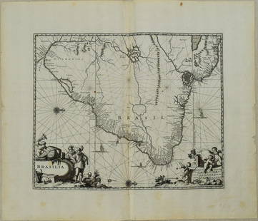
Sold20231671 Ogilby Map of Brazil -- BrasiliaTitle: 1671 Ogilby Map of Brazil -- Brasilia Cartographer: J Ogilby Year / Place: 1671, London Map Dimension (in.): 11.3 X 13.8 in. This is an excellent map of the eastern part of Brazil. There is anSee Sold Price
Sold20231671 Ogilby Map of Panama and Northern South America -- Terra Firma et Novum Regnum Granatense etDescriptionTitle: 1671 Ogilby Map of Panama and Northern South America -- Terra Firma et Novum Regnum Granatense et PopayanCartographer: J OgilbyYear / Place: 1671, LondonMap Dimension (in.): 11.3 X 1See Sold Price
Sold2024Antique Maps - Americas - Emanuel Bowen - North America - South AmericaMap "A new general map of America. Drawn from several accurate particular maps and charts, and regulated by astronomical observations. By Eman. Bowen". An impressive publication by Emanuel Bowen, "A NSee Sold Price
Sold2022Nat. Encyclo. C1875 Lot of 5 Maps - AmericasIncl East and West USA, North America, South America and Canada. Lithograph Map Published C1868-81 by William Mackenzie, London for "The National Encyclopedia: A dictionary of Universal Knowledge"CentSee Sold Price
Sold2023Gross, Alexander 1920 Lot of 11 Large Maps. AmericasIncl Maritime Provinces and Quebec, United States and Mexico, Mexico, USA - South West, USA - South-Central, South America - South East, USA - Climate, South America - North East, South America NorthSee Sold Price
Sold2022Blaeu's carte-à-figures map of AmericasHeading: (Maps) Author: Blaeu, Willem Title: Americæ nova Tabula Place Published: Amsterdam Publisher: Date Published: 1617-[1635] Description: Copper-engraved map, hand-coloredSee Sold Price
Sold2024Map of Americas circa 1588Rare map of the Americas from the atelier of Sebastian Munster, wood block print modeled after a similar map by Ortelius. Basel, Switzerland, ca. 1588. Purchased through Sothebys, London, 2000.OverallSee Sold Price
Sold2016Ortelius' landmark map of AmericasHeading: Author: Ortelius, Abraham Title: Americae Sive Novi Orbis Nova Descriptio Place Published: Publisher:Antwerp Date Published: 1579 Description: Copper-engraved mapSee Sold Price
Sold2020Mercator's map of Americas in 1595Heading: Author: Mercator, Michael Title: America siue India Nova ad Magnæ Gerardi Mercatoris aui Universalis imitationem in compendi um redacta. Per Michaelem Mercatorem Duysburgensem Place PublishSee Sold Price
Sold2018Scarce Large 1634 Map of Americas by M. MerianRare Large Copperplate Engraved Map of the Americas Entitled "America Nouiter Delineata" by Matthäeus Merian (1593-1650) | | Title: America nouiter delineata Title (alt.): America noviter delineata |See Sold Price
Sold2017Sanson: Antique Map of Americas with Atlantis, 1699Map: 1699 Sanson Map of Americas with Mythical Atlantis and California as Island -- Atlantis Insula, a Nicolao Sanson Antiquitati Restituta; nunc demum Majori Forma Delineata, et in Decem Regna, iuxtaSee Sold Price
Sold2020French Cartographic Cabinet Plate Map of AmericasA rare cartographic french porcelain plate depicting a map of the Americas. Surrounded by neo classical desings. The porcelain possibly paris porcelain or Sevres blank with incised letters and numbersSee Sold Price
4 days LeftJasper521671 Ogilby Map of Venezuela -- Venezuela, cum Parte Australi Novae Andalusiae$160
Jun 08Early American History Auctionsc 1730 Hand-Colored Colonial Era Map of the Americas, California shown as an Island, Matted + Framed$500(1 bid)
18 hrs LeftTrillium Antique Prints & Rare BooksPrevost - Chart of the Gulf of Mexico (with Florida & Lousiana)$50(1 bid)
18 hrs LeftTrillium Antique Prints & Rare BooksAudubon - Severn River and Rocky Mountain Flying Squirrel. 143$25


![Nova Hispania Nova Galicia Guatimala. 1671.: [Map/South America] Ogilby, John; Montanus Arnoldus. Nova Hispania Nova Galicia Guatimala. 1671. Hand colored copperplate engraved map. Framed: This map, based on the cartography of Hessel Gerritsz, i](https://p1.liveauctioneers.com/179/268856/140616119_1_x.jpg?height=310&quality=70&version=1668545725)


![Blaeu's carte-à-figures map of Americas: Heading: (Maps) Author: Blaeu, Willem Title: Americæ nova Tabula Place Published: Amsterdam Publisher: Date Published: 1617-[1635] Description: Copper-engraved map, hand-colored](https://p1.liveauctioneers.com/642/234645/121524371_1_x.jpg?height=310&quality=70&version=1643052520)


![[MAP]. ORTELIUS, Abraham. Africae Tabula Nova. 1592. (1 of 2)](https://p1.liveauctioneers.com/197/329395/177650533_1_x.jpg?height=282&quality=70&version=1715364962)


