Sold2020RAND, MCNALLY & CO.'s INDEXED ATLAS of the WORLDPublication Date: 1884 Title: RAND, MCNALLY & CO.'s INDEXED ATLAS of the WORLD Primary Authors: RAND, MCNALLY & CO Publisher: RAND, MCNALLY & CO containing large scale maps of every country and civilSee Sold Price
Sold20231888-9 RAND McNALLY & CO. INDEXED ATLAS OF THE WORLD maps ANTIQUE FOLIORand, McNally & Co.’s new indexed ATLAS OF THE WORLD Chicago; 1888-89 Massive folio. Size 11 by 14.5" Binding is worn with some damages, covers are detached, spine destroyed. Good interior, someSee Sold Price
Sold2023Rand McNally & Co. Indexed Atlas of the WorldIllinois,1881 "Rand, McNally & Co.'s Indexed Atlas of the World Historical and Descriptive" by Rand, McNally & Co. in 1881. Print on paper,15 1/2" x 12". From the collection of a Seekonk, MassachusettSee Sold Price
Sold2018Rand, McNally & Co.'s Indexed Atlas of the World Map ofTitle/Content of Map: Rand, McNally & Co.'s Indexed Atlas of the World Map of New York City Date: 1892 Cartographer: RAND, MCNALLY & CO. Size: 26X19 Pages 62-63 in Rand, McNally & Co.'s Indexed atlasSee Sold Price
Sold2019Rand, McNally & Co.'S Indexed Atlas of the World.Reserve Reduced! Title: Rand, McNally & Co.'S Indexed Atlas of the World. Washington Publication Date: 1888 Cartographer: RAND, MCNALLY & CO. Publisher: RAND, MCNALLY & CO. Size (inches): H19 - W26 MaSee Sold Price
Sold2019Rand, McNally & Co.'S Indexed Atlas of the World.Reserve Reduced! Title: Rand, McNally & Co.'S Indexed Atlas of the World. Oregon Publication Date: 1888 Cartographer: RAND, MCNALLY & CO. Publisher: RAND, MCNALLY & CO. Size (inches): H19 - W26 Map shSee Sold Price
Sold2018Rand, McNally & Co.'S Indexed Atlas of the World Map ofReserve Reduced! Title/Content of Map: Rand, McNally & Co.'S Indexed Atlas of the World Map of Japan.Date: 1892 Cartographer: RAND, MCNALLY & CO. Material/Medium: RAND, MCNALLY & CO. Size: 19 x 25.8 iSee Sold Price
Sold2018Rand, McNally & Co.'S Indexed Atlas of the World Map ofTitle/Content of Map: Rand, McNally & Co.'S Indexed Atlas of the World Map of Philadelphia. Date: 1892 Cartographer: RAND, MCNALLY & CO. Size: 19X25.75 Pages 62-63 in Rand, McNally & Co.'s Indexed atlSee Sold Price
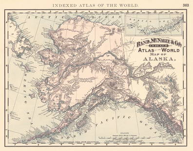
Sold2024Rand, McNally & Co.'S Indexed Atlas of the World Map of AlaskaTitle:Rand, McNally & Co.'S Indexed Atlas of the World Map of Alaska Publication Date: 1892 Cartographer:RAND, MCNALLY & CO. Publisher: RAND, MCNALLY & CO. Height: 9.3 Width: 11.8 Map showing AK withSee Sold Price
Sold2021Rand, McNally & Co.'S New Business Atlas Map ofPublication Date: c1892 Title: Rand, McNally & Co.'S New Business Atlas Map of Chicago. Rand. Mcnally & Co.'S Indexed Atlas of the World Railway Terminal Map Of Chicago. Cartographer: RAND, MCNALLY &See Sold Price
Sold2017Rand McNally: Antique Atlas Map of Asia, 1892Map: Rand, McNally & Co.'S Indexed Atlas of the World Map of Asia Publication Date: 1892 Authors: RAND, MCNALLY & CO., RAND, MCNALLY & CO. Publisher: RAND, MCNALLY & CO. Size: Folio – 19.00 H x 25.8See Sold Price
Sold2017Rand McNally: Indexed Atlas of the World Map of EuropeMap: Rand, McNally & Co.'S Indexed Atlas of the World Map of Europe. Publication Date: 1892 Authors: RAND, MCNALLY & CO., RAND, MCNALLY & CO. Publisher: RAND, MCNALLY & CO. Size: Folio – 19.00 H x 2See Sold Price
Sold2018Rand McNally: Antique Map of Europe, 1898Title/Content of Map: Europe Rand, McNally & Co.'S Indexed Atlas of the World Map of Europe. Date Printed: 1898 ca. Cartographer: RAND, MCNALLY & CO. Publisher: RAND, MCNALLY & COMPANY 1898 ca. CHICAGSee Sold Price
Sold2022Wyoming Rand, McNally & Co.'S New Indexed Atlas of the World. [Wyoming]Publication Date: 1888 Title: Wyoming Rand, McNally & Co.'S New Indexed Atlas of the World. [Wyoming] Cartographer: RAND, MCNALLY & CO. Publisher: RAND, MCNALLY & CO. | THE CONTINENTAL PUBLISHING CO.See Sold Price
Sold2016Map of California, 1899By Rand, McNally & Co., from Indexed Atlas Of The World. Chicago: 1899. Map features vignettes of Los Angeles, San Bernadino, Orange & San Diego Counties and seperate vignette of San Francisco area. DSee Sold Price
Sold2019West Indies Rand, McNally & Co.'S Indexed Atlas Map ofTitle/Content of Map: West Indies Rand, McNally & Co.'S Indexed Atlas Map of the World Map of the West Indies. Date: 1898 Cartographer: RAND, MCNALLY & CO. Publisher: RAND, MCNALLY & CO. Size: 12.3HeiSee Sold Price
Sold2016Rand, McNally & Co. Indexed State and Railroad Map ofRand, McNally & Co. Indexed State and Railroad Map of Mexico. Chicago - New York, 1892. Folded map. Atlas of the World Map of MexicoSee Sold Price
Sold2020Indexed Atlas of the World OregonTitle: Indexed Atlas of the World Oregon Publication Date: 1898 Cartographer: RAND, MCNALLY & CO. Publisher: RAND, MCNALLY & CO. Brief Descriptions: Map detailed with counties separately colored, townSee Sold Price
Sold2020Rand McNally Index Atlas of the World Vol 1 1902Rand McNally Indexed Atlas of the World Historical - Descriptive - Statistical Volume I - United States, Rand McNally & Co, Chicago, 1902. Color engraved atlas of the United States.See Sold Price
Sold20231894 Rand McNally & Co Atlas of the WorldUnited States,1894 "Rand, McNally & Co.'s Atlas of the World" published by Rand, McNally & Company in 1894. Print on paper,22 1/4" x 15 1/2". From the collection of a Seekonk, Massachusetts estate.See Sold Price
Sold2021Rand McNally Indexed Atlas of the WorldIncludes 'Foreign Countries' and 'United States', New York and Chicago, 1897, in original green cloth with gilt lettering, together with Rand McNally's Census Atlas of the World, 1912 Foreign CountrieSee Sold Price
Sold2018Antique Rand-McNally Indexed Atlas of the WorldAntique Rand-McNally Indexed Atlas of the World, ca.1898, pages 5-223 present with color maps, binding is broken and front cover is detached and reinforced with brown tape, some pages are torn, 22" xSee Sold Price
Sold2019Large Colored Map of Louisiana, 1907, from the RandLarge Colored Map of Louisiana, 1907, from the Rand McNally Indexed Atlas of the World, double folio, showing railroads, presented in a mahogany frame with a gilt liner, H.- 19 1/4 in., W.- 25 3/4 in.See Sold Price
Sold2023Scarce early McNally map of Georgia - 1881Early and scarce 1881 Rand McNally Indexed Atlas of the World map of Georgia. Highly detailed, showing counties, towns, rivers, mountains, lakes, roads, railroads, stations, swamps, topography, etc. PSee Sold Price
BonhamsBRADFORD (THOMAS G.) A Comprehensive Atlas, Geographical, Historical & Commercial, 1835; and atl...£500
1 day LeftCrescent City Auction GalleryRand McNally Indexed Terrestrial Globe, 20th c., H.- 40 in., Dia. of Globe- 16 in., Dia. of Base- 17$325
1 day LeftCrescent City Auction GalleryAfter Marie Adrien Persac (French/Louisiana, 1823-1873), "Plantations on the Mississippi River from$325
Jul 06Case Antiques, Inc. Auctions & AppraisalsColton's Atlas of the World, 1856, in Two Volumes; plus Africa / Mahdist War Map$500
BonhamsMITCHELL (SAMUEL AUGUSTUS) A New Universal Atlas Containing Maps of the Various Empires, Kingdom...£1,300


![Wyoming Rand, McNally & Co.'S New Indexed Atlas of the World. [Wyoming]: Publication Date: 1888 Title: Wyoming Rand, McNally & Co.'S New Indexed Atlas of the World. [Wyoming] Cartographer: RAND, MCNALLY & CO. Publisher: RAND, MCNALLY & CO. | THE CONTINENTAL PUBLISHING CO.](https://p1.liveauctioneers.com/5584/256448/133385077_1_x.jpg?height=310&quality=70&version=1659478647)


![[JAPAN ILLUSTRATED] LOT OF 3 VOLUMES SOLD TOGETHER (1 of 7)](https://p1.liveauctioneers.com/8124/333020/179782429_1_x.jpg?height=282&quality=70&version=1718115761)


